Showing posts with label geology. Show all posts

Monday, August 3, 2020

Great trails explore White Sands’ geology

White Sands is the world's largest gypsum sand dune.
Photo courtesy White Sands NPS.
The world’s largest gypsum dunefield sits in southcentral New Mexico. At 275 square miles, about 4.5 billion short tons of white gypsum crystal make up the entire dunefield. White Sands National Park protects the southern half of the field. The dunes rise an average of 30 feet above the surface at White Sands, with the tallest dune about six-and-a-half stories high.

The sand dunes owe their creation to events from 251 million to 299 million years ago during the Permian. At the time, shallows seas covered this part of the world. When they receded, a seabed rich in gypsum was left behind. As the San Andres and Sacramento mountains rose, the gypsum was lifted to higher elevations. Rain dissolved the water-soluble gypsum, with rivers carrying the mineral down the mountains and depositing it in the basin below.

Fast-forward to the end of the last ice age, about 10,000 BC. Large lakes, streams and grasslands filled the Tularosa Basin between the two mountain ranges. As the ice sheets retreated, weather patterns shifted, causing the basin to warm and dry out. One waterbody, Lake Otero, evaporated and became the alkali flat while the grassland turned to desert.

Exposed selenite crystals on the flat eroded into gypsum grains between 8000 and 5000 BC. Prevailing winds then blew the grains eastward, forming dunes, which stabilized about 2000 BC.

Three great trails to explore White Sands’ geology are:
Alkali Flat Trail
Interdune Boardwalk
Playa Trail


Monday, February 26, 2018

Day trails explore Saguaro NP's geology

Javelina Rocks
Saguaro National Park sits in the Sonoran Desert, which stretches 100,000 square miles across northern Mexico and the southwestern United States. It is centered on the Gulf of California, ensuring the desert enjoys subtropical warmth in winter. Rainfall is rare, with an average of 3.5 inches falling annually.

Most of the national park consists of basins and ranges. In the park’s western district, most of the terrain is flat dessert except for the southcentral area where the Tucson Mountains rise. In contrast, the Rincon Mountains cover most of the park’s eastern section with only the western and southwestern edges flat desert.

For most of Earth’s history, the area now making up Saguaro National Park was underwater, a great contrast to its aridity today. Around 1.7 billion years ago, it likely was near the boundary of two tectonic plates, where rocks heated into magma then cooled and solidified into Pinal Schist. The park’s oldest rocks, which can be seen off of Cactus Forest Loop Drive in the park’s eastern Rincon Mountain District, is this schist. Nearby on the Tanque Verde Ridge are 1.4-billion-year-old altered granites. The ridge can be hiked on the aptly named Tanque Verde Ridge Trail

Around 600 million years ago, shallow seas covered the area. As rivers carried sediment into the sea and ancient shelled sea life died and floated to the sea floor, sandstone, limestone, and shale formed.

About 80 million to 30 million years ago, western North America underwent an era of mountain building. Volcanoes formed the Tucson Mountains about 70 million years ago, during the Age of Dinosaurs. When one volcano collapsed, it formed a caldera 12 miles wide; debris and lava since has filled it. Granite from the magma chamber that fed these volcanoes can be seen today at the Sus Picnic Area.

For the past 30 million years, the mountains and basin that Tucson sits in have been undergoing great change. The Earth’s crust from northern Mexico to Oregon is thin and so pulling apart along fault lines. As the crust stretches, the areas along fault lines drop in elevation, pushing up the harder, erosion-resistant rock next to it. The Tucson and Rincon Mountain in the park, we well as the Santa Catalina Mountains north of Tucson, all rose to their current height in this way.

This also has exposed the crystallized granite, known as Santa Catalina gneiss, in the Rincon Mountain district, most notably at Javelina Rocks. The same type of rock sits below the Tucson Mountain but has yet to reach the surface.

Other great geology-oriented trails to hike at Saguaro include:
Ernie's Falls Trail (waterfall)
King Canyon Trail (heads to Wasson Peak's summit) 
Turkey Creek Trail (heads to Mica Mountain's summit)

Sunday, September 17, 2017

Trail crosses ancient great lake beach ridge

Autumn colors line the forest at Woodland Dunes Nature Center and Preserve.
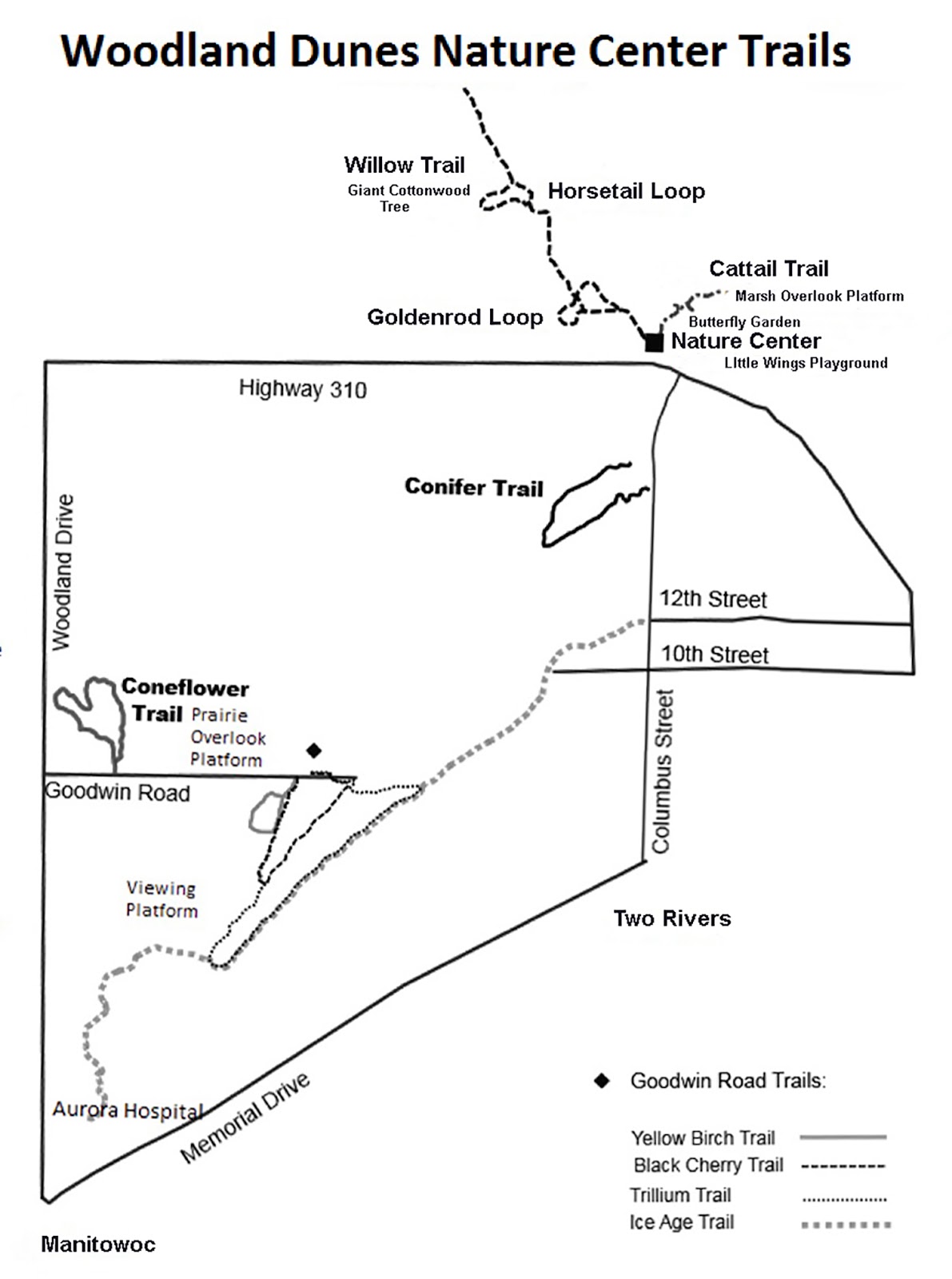
Conifer Trail map. Click for larger version.
Hikers can walk upon what 5000 years ago was a Lake Michigan beach ridge in Wisconsin.

The 0.5-mile Conifer Trail at Woodland Dunes Nature Center and Preserve located near the great lake between Manitowoc and Two Rivers. Entirely wooded now, it makes for a great autumn hike.

To reach the trailhead, from Manitowoc take Wis. Hwy. 42 north toward Two Rivers. Turn left/north onto Columbus Street and left/west onto Wis. Hwy. 310. If in Two Rivers, take Hwy. 310 west toward Interstate 43. Immediately after Columbus Street, turn right/north into the preserve’s nature center and park there. To reach the trailhead, head south alongside Columbus Street; a sign identifies the trailhead, about two blocks from the nature center, on the road’s west side.

The looping trail follows two ancient beach ridges – elevated areas of sand and sediment swept there by waves. It crosses a swale – a low-lying area – between the ridges.

But how can there be beach ridges when Lake Michigan is more than a half-mile away?

These are ancient beach ridges and swales, remnants from a time with Lake Michigan was larger. In fact, it wasn’t exactly Lake Michigan then but Lake Nipissing.

As the heavy glaciers retreated some 10,000 years ago, the depressed crust of North America rebounded. The result was higher levels in Lake Nipissing, which is basically today’s Lake Michigan, except 30 feet higher. This inundated low-laying land to the lake’s east and south. Breaking waves bulldozed the lake’s sandy bottom, creating a series of parallel underwater ridges and troughs.

Gradually water drained from Lake Nipissing, and the shoreline retreated. As it did, those underwater ridges and troughs became above water sand dunes and swales. Plants common to beach dunes kept these ridges and depressions in place. Over the centuries, shrub carr replaced the dune plants, paving the way for forests to take root and grow.

Today, a mixed hardwood-conifer forest covers the Conifer Trail’s beach ridges and swale. Signs along the trail point out the different types of trees, with the hardwoods consistently mainly of beech, sugar maple, basswood, red and white oak.

That makes for a splendid autumn display – the bronze of American beech, the yellows, oranges and reds of sugar maple, the brown of red oak and the scarlet of white oak, all mixed with the olive leaves of basswood and evergreen needles of the conifers.

The beech trees are particularly interesting as they primarily grow in hardwood forests along Lake Michigan and are absent in most of the rest of Wisconsin. The American beech grows up to 60-75 feet high and boasts a broad, oval canopy. They prefer organically rich, acidic, loamy soils, common along Lake Michigan.

After completing the loop, walk left/north along Columbia Street and return to the nature center.


Monday, January 23, 2017

5 Day Hikes Past Amazing Rock Formations

Badlands National Park
Badlands National Park trails
Among the iconic sites of South Dakota’s Black Hills region is the Badlands, a bizarre menagerie of spires and domes encased by striped, twisting canyon walls. The Badlands also is a treasure trove of fossils – reptile sea monsters, rhinoceroses, camels, three-toed horses, clams, ammonites and more.

Balanced Rock Trail
Arches National Park
Day hikers can take a short walk to an astounding 55-foot tall block on the Balanced Rock Trail at Arches National Park in eastern Utah. The trail leads to a dinosaur-era rock that looks like a ball atop a pedestal. The sandstone spire technically is known as a hoodoo.

Queens Garden
Bryce Canyon National Park
Fairyland really does exist – it’s smack dab in southcentral in Utah, where a maze of totem pole-like rock formations called hoodoos grace Bryce Canyon National Park. Hoodoos are unusual landforms in which a hard caprock slows the erosion of the softer mineral beneath it. The result is a variety of fantastical shapes. Children will delight in the chimerical scenery encircling Bryce Canyon’s Queens Garden.

Devils Postpile Trail
Devils Postpile National Monument
A massive collection of nearly perfect hexagonal columns of rock await day hikers on the Devils Postpile Trail in California. The trail is an easy 0.9-mile round trip hike in Devils Postpile National Monument southeast of Yosemite National Park. The national monument protects the Devils Postpile formation – which this trails heads to the top of – and the 101-foot Rainbow Falls.

Learn more about national park day hiking trails in my Best Sights to See at America’s National Parks series.


Thursday, December 22, 2016

Trails head over half-billion-year-old rocks

The largest outcropping at Javelina Rocks.
Day hikers can scramble over boulders more than a half-billion years old at Javelina Rocks in Arizona’s Saguaro National Park.

There’s no official trail
at the rock formation,
but several narrow paths circle and head into the five rock outcroppings. You easily can put on a half-mile of walking at
the sight in the park’s eastern Rincon Mountain District.

To reach the trailhead, from Interstate 10 in Tucson exit onto East Speedway Boulevard and head east. Turn right/south onto Freeman Road then left/south onto Old Spanish Road. Next, enter the park by turning left/east onto Cactus Forest Drive. The park’s eight-mile road eventually becomes a one-way. A parking pullout for Javelina Rocks is between the six and seven mile markers. Expect the lot to be full on spring weekends.

The trail heads northwest from the parking lot toward the largest of the five outcroppings. Saguaros, cholla cacti, and desert wildflowers surround the rocks.

The outcroppings are Santa Catalina gneiss, formed some 541 million years ago when a tectonic plate begin to split apart. As it did, land heading in one direction slipped downward at an angle against the land moving in the other direction, This friction resulted in high temperatures and pressures that created the gneiss.

Five minerals – quartz, feldspar, mica, magnetite, and garnet – make up the gneiss. They are quite resistant to erosion, which has exposed the outcroppings by blowing and washing away the weaker soil surrounding them.

The three smaller outcroppings are perfect for kids to scramble upon and make a great spot to watch sunsets. The larger two outcroppings offer a great challenge to those who wish to test their scrambling skills, and because of that you’ll also enjoy more solitude there.

The trails between them offer great views of the Catalina Mountains to the north. During winter, they’re typically snow-capped.

If lucky, you may spot the rock’s namesake, the javelina. The pig-like creatures like to congregate at the rocks, which provide shade and shelter.

Other small animals can be found at the rocks as well. There will be plenty of small, harmless lizards, and sometimes a curve-billed thrasher can be spotted perched on the ocotillo.

Be sure to bring some lunch or a snack with you. After clambering around the rocks, drive to the nearby Javelina Picnic Area, where the outcroppings make a great backdrop to a meal.

AERIAL MAP OF SITE
Click for larger version.


Friday, December 2, 2016

Trails explore Voyageur NP’s geology

Ancient rocks and Lake Kabetogama behind the Ash River Visitor Center
at Voyageurs National Park.
Eons ago, the area that now makes up Voyageurs National Park sat near the southern edge of Canadian Shield – a gigantic dome of volcanic bedrock that birthed North America. In fact, the park is one of the few places where you can see and touch rocks older than 2.8 billion years, more than half of the planet’s age.

This early rock appears in multiple places. The bedrock on the shore of Sand Point Lake’s Brown Bay is about 2.7 billion years old. Other outcroppings of the ancient stone can be seen elsewhere throughout the park, including the Echo Bay Trail.

During the Archean, mountains were building in what is now the park as another tectonic plate slid under the Canadian Shield. It was similar to the Pacific plate sliding against the North American plate in modern day California, leading to the rising of the Coast Ranges there. The result at Voyageurs was the creation of the bedrock that makes up the current state south to the Minnesota River Valley.

This same process caused volcanic islands to form offshore. The lava basins along the ancient fault lines eventually became greenstone belts that held a variety of metals and minerals, such as gold, silver and copper. An attempt was made to mine gold from this belt during the 1890s; the abandoned mine can be hiked on the Little American Island Trail.

Eventually, erosion wore down the volcanic mountain ranges. What happened afterward until about 190,000 years ago is a mystery, though.

That’s because repeated periods of glaciation during the intervening years scraped off the topsoil and rock layers, exposing the Canadian Shield and ancient mountain building that left behind granite, biotite, schist, migmatite and greenstone. The last ice age about 11,000 years ago also finished gouging out several depressions; as retreating glaciers melted, the water settled in those massive troughs, creating the park's major lakes. Park visitors can walk across some of this rock next to those ice age lakes behind the Ash River Visitor Center.

Learn more about the park's day hiking trails in my Best Sights to See at Voyageurs National Park guidebook.


Monday, November 28, 2016

5 Hikes Past Fascinating Rock Formations

Door Trail in Badlands National Park.
Trail of the Gargoyles
Stanislaus National Forest
An otherworldly array of rock formations await day hikers on the Trail of the Gargoyles in California’s Stanislaus National Forest. The national forest consists of more than 900,000 acres bordering Yosemite National Park’s north side. With 480 miles of marked hiking trails, the national forest makes a great alternative for those wishing to avoid Yosemite’s crowds.

Ledges Trail
Cuyahoga Valley National Park
Families can traipse across 320 million-year-old formation, created when great coal swamps covered the earth, via the Ledges Trail at Cuyahoga Valley National Park. The Ledges Trail plus the stem to it runs 2.8-miles.

Door Trail
Badlands National Park
Hiking the Door Trail in Badlands National Park is like a two-for-one deal. The trail begins amid the prairie’s level and open grasslands. It ends in a bizarre menagerie of spires and domes encased by striped, twisting canyon walls. 

Watchman Trail
Zion National Park
Hikers can see several of Zion National Park’s exotic geological formations on the short Watchman Trail. The trail runs 2.8-miles round trip through Zion Canyon in the Utah park. Among the sights are The Watchman, the Towers of the Virgin, the Altar of Sacrifice, and the West Temple.

Skull Rock Trail
Joshua Tree National Park
Families can day hike with their children to Skull Rock – not the one in Neverland of “Peter Pan” fame but one bearing an uncanny resemblance – in the Mojave Desert. The Skull Rock Trail runs 1.75-miles round trip in Joshua Tree National Park. For those staying at the nearby Jumbo Rocks Campground, it’s a must-see. 

Learn more about national park day hiking trails in my Best Sights to See at America’s National Parks series.


Thursday, June 16, 2016

Day trails offer look into RMNP’s geology

Longs Peak at Rocky Mountain National Park. Courtesy of Wikipedia.
Day hikers can explore the complex geology of Rocky Mountain National Park via several excellent trails.

The park’s geology began about a billion years ago when molten lava formed large amounts of granite in what is now Colorado. About 500 million years ago, the land begin to sink and fill with sediment, forming several rock strata.

Then, some 300 million years ago, the land rebounded. A range known as the Ancestral Rocky Mountains formed. It eroded over a period of 150 million years, covering its stubs in its own sediment. A series of erosion and sandstone/shale formations occurred over the next 220 million years.

The Front Range of the park formed between 80 million and 40 million years ago during the Laramide Orogeny. (An "orogeny" is a mountain-building event). At that time, two tectonic plates – the Kula and the Farallon – collided with North America’s western coast. As those plates slid under North America, rock set down over the previous billion years bunched up and wrinkled; those “wrinkles” are the mountains we now see.

Immediately after being thrust upward, the park and the rest of the Rockies looked much different than today, as it was a plateau more than 19,000 feet high. Then about 60 million years ago, this plateau began to erode, forming valleys and summits. The peaks today mostly top out in the 14,000-feet range, about a mile lower than the plateau. Hikers can see one of the Front Range’s most prominent 14ers, Longs Peak, via the Bluebird Lake Trail.

Periods of glaciation that started about 1.8 million years ago deeply shaped the park and Rockies into the landscape we know today. U-shaped valleys as well as cirques (concave-shaped valleys) are signs of past glaciers in the area. The last ice age ended around 11,000 years ago, though remnants of some glaciers still remain. One easy and scenic route to see how glaciers shaped the park is the Alberta Falls Trail, where a waterfalls tumbles over a creek that runs from a gorge created by a glacier. You actually can enter that gorge via the Mills Lake Trail.

Learn more about the park's day hiking trails in my Best Sights to See at Rocky Mountain National Park.


Sunday, June 12, 2016

Yosemite trails offer look at park’s geology

Glaciers carved the valleys and fascinating granite shapes at Yosemite.
Today’s fascinating geography of Yosemite National Park arose from a complex number of geological events that date to well over 540 million years ago. Prior to that time, the area where the park sits marked the edge of the North American continent. Rivers carried sediment from inland into a shallow sea; over hundreds of millions of years, this sediment hardened into rock, ultimately claiming the sea for the continent.

As the North American tectonic plate collided with another plate, those rocks – metamorphosized into marble, quartzite and slate – rose above the seabed. Chains of island volcanoes formed in the ocean off the continent and gradually was rode its plate into and combined with ancient North America. These rocks can be seen in isolated sections of Yosemite’s central and northern section as well as the neighboring Emigrant Wilderness of the neighboring Stanislaus National Forest.

Much of the granite exposed today at the national park formed deep underground during these plate collisions about 210 million to 80 million years ago. As plates continued to strike one another, the heavier ocean floor drove beneath the lighter continental land mass, beginning lifting up the Sierra Nevada mountains about 10 million years ago. Over time, softer rock eroded away, exposing much of the granite now seen at the park.

A series of ice ages beginning about 3 million years ago covered Yosemite in glaciers. As these hefty masses of ice pushed through the mountains, melting and advancing again and again, they carved out the deep valleys and shaped the granite. In some cases, the glaciers sheared massive chunks of the exposed granite domes and left creeks and rivers dropping hundreds and sometimes thousands of feet down newly created cliffs. The glaciers’ action can most dramatically be seen in Yosemite Valley, especially the Cook’s Meadow Loop and Lower Yosemite Fall Trail. You can hike up through some of the rock currently being cut away by the Merced River on the Mist Trail.

Learn more about national park day hiking trails in my Best Sights to See at America’s National Parks guidebook.


Monday, May 9, 2016

Trails explore St. Croix County WI geology

Rocks forming the cliffs that Willow River cuts through were formed about
half-a-billion years ago.
Hikers can explore the geology of Wisconsin’s St. Croix County via a number of great day trails. Located just east of Minneapolis-St. Paul, the county is easy to reach via Interstate 94.

Underlying the entire county is 1.1 billion year old bedrock, formed when the North American continent began to split in two. From this rift flowed thousands of feet of lava. In the county, these flaws included the area northwest of where the Willow River runs today while the rest of the county mainly contains clastic rock, which is weathered rock that rivers dumped into the rift’s depression.

Fast forward a half-billion years. At that time – the Cambrian and Ordovician periods – the county sat in a sea off the edge of North America. Northern Wisconsin was a high coastal area. As rivers carried sediment off these eroding mountains, the sand and silt settled in the sea for more than 100 million years. As sea life grew more complex near the end of that period, their falling shells settled in the sediment, creating the marine limestone underlying much of the county’s topsoil. Cliffsides of this rock can be seen today at Willow Falls where the Willow River has cut through it; it can be reached via the Willow Falls Hill (Gray) Trail at Willow River State Park.

Two ancient faults during that time offset the rocks layers by as much as 400 feet in the county. One fault runs north of Hudson. The other one, known as the Hudson Fault, sits in the state park on the eastern side of Little Falls Lake. You can walk over the latter fault on the Willow Falls (Blue) Trail at Willow River State Park.

Fast forward nearly another half-billion years. About 2.5 million years ago, the Earth entered a series of ice ages. Much of the landscape seen today in St. Croix County exists as it does because of those glaciers. During one of those glacial periods more than 100,000 years ago, an ice sheet engulfed the entire county.

In the last ice age, which began about 100,000 years ago and ended a mere 8000 years ago, the leading edge of the Superior Lobe of the Laurentide Ice Sheet covered the county’s northwestern corner. It formed moraines – ridges of rock and sediment carried by glaciers – and kettle lakes, where melting ice broken from retreating glacier formed a depression, with the trapped meltwater forming a waterbody. Moraines are visible on the Mound (White) Trail at Willow River State Park and a kettle lake on the Siem Trail, located in the Homestead Parklands on Perch Lake.

Most noticeably, the St. Croix River served as a major drainage for meltwater from retreating glaciers with flashfloods scouring out the St. Croix River Valley. The Hudson Pier, at Lakefront Park in downtown Hudson, runs to the center of the river valley. During the height of the glacial drainage, the pier would have been a few hundred feet under the river.

Learn more about nearby day hiking trails in my Day Hiking Trails of St. Croix County series.


Sunday, March 20, 2016

Explore Great Smoky Mountains’ geology

The highest points of the Great Smoky Mountains consist of
erosion-resistant metasandstone.
One billion years ago, the area that now is the Great Smoky Mountains sat in an ocean at the edge of the North American continent. As clay, mud, sand and silt eroded off a nearby highlands, they filled the water, forming a layer nine-miles thick.

Much of the rock currently at the national park’s surface are sedimentary layers that piled atop that layer over a span of 95 million years beginning about 545 million years ago. Fossils of sea creatures – burrows of worms and shells of crustaceans – can be found in these sedimentary layers at the park, most notably Cades Cove.

About 310 million years ago, the North American and African tectonic plates crashed into one another. For the next 65 million years, this grinding of plates pushed up land all along the North American coastline, creating the Appalachian Mountains, which stretched from Newfoundland to Alabama. At one time, the Appalachians stood as high as the Rocky Mountains do today.

As the two tectonic plates separated and moved to their current positions, erosion began to tear down the Appalachians. Rivers and streams moved the sand and silt to the Atlantic Ocean and Gulf of Mexico; in fact, some of today’s Gulf of Mexico beaches are made of eroded rock from what is now the Great Smoky Mountains.

The most resistant of those rocks – metasandstone – remain the park’s highest peaks. The majority of waterfalls occur at metasandstone ledges.

In the millennia ahead, the Great Smoky Mountains eventually will erode away. Geologists estimate the park is losing about an inch of elevation every 500 years.

Some great spots to explore the park’s geology include:
Chimney Tops Trail
Clingmans Dome Trail
Rainbow Falls Trail

Learn about other great trails at this national park in Best Sights to See at Great Smoky Mountains National Park.


Saturday, September 13, 2014

Trails explore Washburn County geology

The Namekagon River cuts through sediment laid down by glaciers.
Two lengthy geological events shaped the terrain of Wisconsin’s Washburn County: the erosion of a vast mountain range and the ice ages of the past million years. Several trails allow modern hikers to explore that geology.

About 600-700 million years ago, the northern third of the county was part of a great Alps-like mountain range stretched. Most of what is now central and southern Wisconsin lay under an ocean.

Over the eons, streams and rivers carried sediment out of these mountains, filling the shallow sea inch by inch. The sandstone found in road cuts and on river banks across the southern part of the county and Wisconsin as a whole are those piles of sediment.

Erosion has worn those mountains down into a relatively flat area, with occasional hills, called a peneplain. While evidence of these mountains doesn't rise above the surface in the county, you can walk through the area where they once rose on the Totagatic Ski Trail.

Then, glaciers during the last ice age (which ended about 10,000 years ago) brought sediment – mainly sand, gravel and boulder clay – that was left across the base of those ancient mountains and the filled-in sea. Because of this, the northern part of the county generally is better for forests than farming, which in our century shapes up to great hiking trails. The Namekagon River cuts through a deep portion of this sediment, visible on the Trego Nature Trail.

The southern two-thirds of the county is largely shaped by ice as well. As the glaciers melted and retreated at the end of the last ice age, they left long narrow mounds of sediment called hummocks. Ice-walled lakes also formed, leaving whole swaths of land fairly flat. You can day hike through such terrain on the Ice Age National Scenic Trail.

The county’s central hilly area – known as the Spooner Hills – were created by till piling up during several glacial advances. The spacing between the hills likely developed when melting ice at the glacier’s bottom formed tunnels so that the water flowed outward into the open plain to the south.

Learn about nearby trails in Day Hiking Trails of Washburn County.