Showing posts with label Willow River State Park. Show all posts

Monday, May 9, 2016

Trails explore St. Croix County WI geology

Rocks forming the cliffs that Willow River cuts through were formed about
half-a-billion years ago.
Hikers can explore the geology of Wisconsin’s St. Croix County via a number of great day trails. Located just east of Minneapolis-St. Paul, the county is easy to reach via Interstate 94.

Underlying the entire county is 1.1 billion year old bedrock, formed when the North American continent began to split in two. From this rift flowed thousands of feet of lava. In the county, these flaws included the area northwest of where the Willow River runs today while the rest of the county mainly contains clastic rock, which is weathered rock that rivers dumped into the rift’s depression.

Fast forward a half-billion years. At that time – the Cambrian and Ordovician periods – the county sat in a sea off the edge of North America. Northern Wisconsin was a high coastal area. As rivers carried sediment off these eroding mountains, the sand and silt settled in the sea for more than 100 million years. As sea life grew more complex near the end of that period, their falling shells settled in the sediment, creating the marine limestone underlying much of the county’s topsoil. Cliffsides of this rock can be seen today at Willow Falls where the Willow River has cut through it; it can be reached via the Willow Falls Hill (Gray) Trail at Willow River State Park.

Two ancient faults during that time offset the rocks layers by as much as 400 feet in the county. One fault runs north of Hudson. The other one, known as the Hudson Fault, sits in the state park on the eastern side of Little Falls Lake. You can walk over the latter fault on the Willow Falls (Blue) Trail at Willow River State Park.

Fast forward nearly another half-billion years. About 2.5 million years ago, the Earth entered a series of ice ages. Much of the landscape seen today in St. Croix County exists as it does because of those glaciers. During one of those glacial periods more than 100,000 years ago, an ice sheet engulfed the entire county.

In the last ice age, which began about 100,000 years ago and ended a mere 8000 years ago, the leading edge of the Superior Lobe of the Laurentide Ice Sheet covered the county’s northwestern corner. It formed moraines – ridges of rock and sediment carried by glaciers – and kettle lakes, where melting ice broken from retreating glacier formed a depression, with the trapped meltwater forming a waterbody. Moraines are visible on the Mound (White) Trail at Willow River State Park and a kettle lake on the Siem Trail, located in the Homestead Parklands on Perch Lake.

Most noticeably, the St. Croix River served as a major drainage for meltwater from retreating glaciers with flashfloods scouring out the St. Croix River Valley. The Hudson Pier, at Lakefront Park in downtown Hudson, runs to the center of the river valley. During the height of the glacial drainage, the pier would have been a few hundred feet under the river.

Learn more about nearby day hiking trails in my Day Hiking Trails of St. Croix County series.


Friday, July 10, 2015

Video of White Tail (Red) Trails at WI park

Day hikers can enjoy a pleasant walk amid a meadow and oak woods on the White Tail (Red) Trails at Wisconsin’s Willow River State Park. The combination of 2.66-miles of trails offers an opportunity to spot white-tailed deer and listen to songbirds.

To reach the park, from Interstate 94 east of the Minneapolis-St. Paul metro area, take Exit 4 and head north on U.S. Hwy. 12 for about 1.6 miles. When Hwy. 12 turns east, continue straight on County Road U for about 0.3 miles to County Road A, where you’ll continue for another 1.5 miles. The park’s entrance is on the road’s left/west side. The park’s entrance is on the road’s left/west side. Park in the lot for the Group Campground on the entry road’s south side.

Here’s a video of a cluster of oak trees with songbirds taken during spring along the White Tail (Red) Trails:


Here's an article more fully describing the trail.

Learn more about nearby day hiking trails in my Day Hiking Trails of St. Croix County guidebook.


Thursday, July 2, 2015

Hike along famous Wisconsin trout stream

Willow River alongside the Trout Brook (Purple) Trail.
Trout Brook (Purple) Trail

Stem, three loops
offer variety of
interesting routes


Day hikers can amble alongside a popular trout stream on the Trout Brook (Purple) Trail at Wisconsin’s Willow River State Park.

A stem and three stacked loops, the trail offers a several hiking options to meet a variety of fitness levels. The majority of the trail is flat and well-maintained.

To reach Willow River State Park, from Interstate 94 take Exit 4 and head north on U.S. Hwy. 12 for about 1.6 miles. When Hwy. 12 turns east, continue straight on County Road U for about 0.3 miles to County Road A, where you’ll drive for another 1.5 miles. Turn left/west into Willow River’s main entrance and follow the park road to a set of three parking lots at its terminus.

The trail can be accessed from the west side of the southern and middle parking lots. Look for the purple trail blaze – the trail starts at the western terminus of the Little Falls (Green) Trail – and cross the entry road. The wide trail enters a woods of mixed northern hardwoods and roughly parallels the Willow River.

In 0.08 miles, the path junctions with the Oak Ridge (Brown) Trail. Continue straight, passing a small wetlands on its south side.

Once you hear the rush of the river over rapids, the path is coming upon a footbridge that marks the southern end of the Nelson Farm (Silver) Trail, which heads north. The footbridge is at 0.62 miles from the trailhead. Additional rapids are west of the bridge.

The Trout Brook (Purple) Trail marks an excellent route for watching birds of all varieties. More than 90 unique species ranging from songbirds to water fowl and even a few raptors have been spotted on the trail.

Don’t be surprised if you also see white-trailed deer along the way. They like the cover and feeding grounds offered by the oak forest to the trail’s south and east.

At 0.72 miles from the trailhead, you’ll reach the middle of three stacked loops. They are named here the Western, Middle and Eastern loops based on their compass direction.

Western Loop
From the stem trail, go right/west to the part of the path that accesses both the Western and the Middle loops. In 0.08 miles, the trail junctions with the Western Loop, which heads back to a section of the Willow River known as The Race. At one time, this section of the Willow was a premier trout fishing stream.

Today, brown trout, smallmouth bass and bluegill dominate the Willow. Though long past its peak trout days like so many other rivers, you still can spy a fly fisher out on the banks.

The “three sides” of the western loop run 0.47 miles. They junction on the western side of the middle loop; take the middle loop left/north for 0.17 miles to reach the stem trail and return to the lot.

Middle Loop
To do the Middle Loop, from the stem trail simply avoid turning on any of the junctions and stay on the middle walking path. This route runs 0.84 miles through woodlands before returning to the stem trail.

Eastern Loop
Going left/east from the stem trail onto the Middle Loop provides access to the Eastern Loop.

In 0.1 miles from the stem trail, the path reaches the junction with the Eastern Loop; head left/east onto it. The amoeba-shaped loops runs 0.75 miles and briefly touches the western side of the aforementioned wetlands.

When the trail junctions again with the Middle Loop, go right/north onto it. In 0.27 miles, you’ll reach the stem trail.

Of course, depending on your energy levels, the loops can be combined in a variety of ways to lengthen the walk. Or the loops can be skipped altogether; arguably, the prettiest part of the walk is the stem trail, which if done on its own runs 1.44-miles round trip.

Learn more about nearby day hiking trails in my Day Hiking Trails of St. Croix County.


Wednesday, June 24, 2015

Photos of Willow River’s White Tail Trails

Photo album of Willow River State Park’s White Tail (Red) Trails The scenic White Tail (Red) Trails run for a combined 2.66 miles in Wisconsin’s Willow River State Park near the Minnesota border.

To reach the park, from Interstate 94 take Exit 4 and head north on U.S. Hwy. 12 for about 1.6 miles. When Hwy. 12 turns east, continue straight on County Road U for about 0.3 miles to County Road A, where you’ll continue for another 1.5 miles. The park’s entrance is on the road’s left/west side. Park in the lot for the Group Campground on the entry road’s south side.

From the lot, walk east, looking for the orange blaze of the Knapweed Trail. That route heads up a knoll through a small woods that opens up to a grassy area (below). Turn right/west and follow the red blazes for the White Tail Trails.


White-tailed deer like to graze in the meadows along the trail (below), hence the trail’s name.


Songbirds are plentiful on the trail thanks to the oak woods and birdhouses in the meadow (below).


The woodline consists mainly of oaks with a few other trees mixed in (below).


Here's a full description of the trail.

Learn more about nearby day hiking trails in my Day Hiking Trails of St. Croix County guidebook.


Monday, June 8, 2015

Spot white-tailed deer on stacked loops

The White Tail (Red) Trails skirts an open meadow and oak woods popular
with white-tailed deer.

Routes cross meadow near Willow River


A pleasant walk through a meadow awaits hikers of the White Tail Trails at Wisconsin’s Willow River State Park.

The trail consists of a stem leading to two stacked loops, allowing for circuit hikes of between 1.6 to 2.2 miles. Most of the trails’ surface is mowed grass, making this a great spring trail when other paths are still muddy from melting snow and rainfall.

To reach the park, from Interstate 94 take Exit 4 and head north on U.S. Hwy. 12 for about 1.6 miles. When Hwy. 12 turns east, continue straight on County Road U for about 0.3 miles to County Road A, where you’ll drive for another 1.5 miles. The park’s entrance is on the road’s left/west side. Park in the lot for the Group Campground on the entry road’s south side.

From the lot, walk east, looking for the orange blaze of the Knapweed Trail. That route heads up a knoll through a small woods that opens up to a grassy area. At the trail intersection upon reaching the prairie, go left/west along the tree line. This is the stem trail for the White Tail (Red) Trails.

State wildlife animal
The woodline consists mainly of oaks with a few other trees mixed in. On the opposite side of the woods to the north is the aptly named Oak Ridge (Brown) Trail.

To the south and west, however, is a restored meadow. White tail deer tend to graze here, hence the trail’s name.

While white-tailed deer can be found throughout North America, they’re ubiquitous in Wisconsin. About 1.2 million white-tailed deer roam the state, nearly one for every three residents. The state’s official “wildlife animal,” many hunters here await the annual November gun season with the same excitement as kids at Christmas.

White-tailed bucks usually top a hundred pounds with mature ones sporting large sets of antlers. Despite their skinny legs, they can run up to 40 miles an hour and jump nine feet.

Even if you don’t see a deer while hiking this trail, you’re certain to notice signs of their presence. Watch for deer tracks on the trail’s few sandy or muddy portions. Where the route skirts the forest, look for trees with bark chewed off the trunks.

Long vs. short trail
In addition to white-tailed deer, two badgers were spotted along the trail in 2010. Songbirds also are plentiful.

About 1.6 miles from the Knapweed Trail intersection, the stem comes to the two stacked loops that make up the White Tail Trails.

For the northern loop, go right/northwest. In 0.14 miles, the trail intersects the Oak Ridge Trail then in 0.51 miles reaches the second loop. To complete the northern loop, take the middle trail east through the meadow for 0.51 miles back to where the stem trail met the loops. This hike, including the stem trail, runs 1.6-miles round trip.

For the longer southern loop, go left/south. After 1.3 miles, the route junctions with the northern loop. Turn right/east onto the middle trail, and in 0.51 miles, you’ll reach the stem trail. This hike, with the stem trail, clocks in at 2.2-miles round trip.

Learn more about nearby day hiking trails in my Day Hiking Trails of St. Croix County guidebook.


Sunday, May 31, 2015

Video of Willow River SP's Knapweed Trail

Day hikers can walk the edge of prairie that botanists are restoring on the Knapweed (Orange) Trail at Wisconsin’s Willow River State Park. The 0.9-mile one-way trail also offers a short walk through a piney woods.

To reach the park, from Interstate 94 take Exit 4 and head north on U.S. Hwy. 12 for about 1.6 miles. When Hwy. 12 turns east, continue straight on County Road U for about 0.3 miles to County Road A, where you’ll continue for another 1.5 miles. The park’s entrance is on the road’s left/west side. Park in the lot for the Group Campground on the entry road’s south side.

Here’s a video of a portion of the prairie along the Knapweed Trail, taken in early May:


Here's an article more fully describing the trail.

Learn more about nearby day hiking trails in my Day Hiking Trails of St. Croix County guidebook.


Saturday, May 23, 2015

Photo album of Knapweed (Orange) Trail

The scenic Knapweed (Orange) Trail rambles about 0.9 miles one-way through a prairie that’s being restored in Wisconsin’s Willow River State Park.

To reach the park, from Interstate 94 near the Minnesota border, take Exit 4 and head north on U.S. Hwy. 12 for about 1.6 miles. When Hwy. 12 turns east, continue straight on County Road U for about 0.3 miles to County Road A, where you’ll continue for another 1.5 miles. The park’s entrance is on the road’s left/west side. Park in the lot for the Group Campground on the entry road’s south side.

The trailhead (below) is southeast of the parking lot. Watch for the orange trail blaze.
After cresting a knoll, the trail reaches a grassy area that is the prairie under restoration (below). At the trail intersection, go left/east.


The trail is named for an invasive species (below, photo courtesy of Wisconsin DNR) that for better or for worse dominates the route.


The last section of the trail heads through a wooded area (below) near the park office. It then crosses the park entry road and ends at a junction with the Pioneer (Yellow) Trail.


Here's a full description of the trail.

Learn more about nearby day hiking trails in my Day Hiking Trails of St. Croix County guidebook.


Monday, May 11, 2015

Video of Willow River SP's Little Falls Lake

Among western Wisconsin’s prettiest waterbodies near an urban area is Little Falls Lake.

Located in Willow River State Park at the edge of the Minneapolis-St. Paul metro area, the lake covers 170 acres and discounting an island on the eastern side, offers 4.12 miles of shoreline in the park. Home to panfish, largemouth bass, smallmouth bass, and northern pike, the lake reaches a depth of 18 feet.

A beach stretches for 400 feet along a section of the shoreline. Amenities include picnic tables, beach house, playground, and restrooms.

Here’s a brief video of buffleheads swimming on Little Falls Lake:


A great trail to enjoy the lake from is the Little Falls (Green) Trail. The paved route skirts the lake’s southeastern shore for 0.6 miles one-way (1.2-miles round trip).

Learn more about nearby day hiking trails in my Day Hiking Trails of St. Croix County guidebook.


Thursday, May 7, 2015

Video of Wisconsin’s Willow Falls

Among Wisconsin’s most impressive waterfalls is Willow Falls.

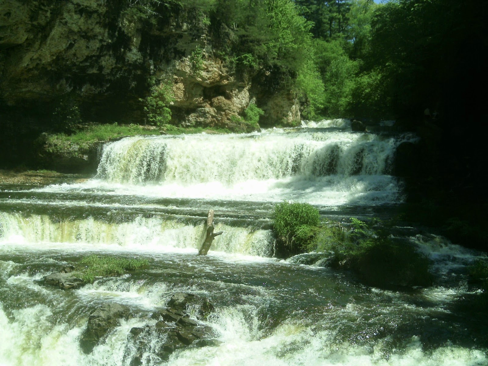
Located in Willow River State Park near the Minnesota border, the Willow River descends 45 feet over the falls. The main drop is about 15 feet high but more than a hundred feet wide.

A sandstone gorge nestles the falls beneath 200-foot high walls. Geologists estimate the rock at the bottom of the gorge is about 600 million years old and have found trilobite fossils in it.

Here’s a brief video showing Willow Falls:


A great trail to see the terraces from is the Willow Falls Hill (Gray) Trail. It runs 0.85-miles round trip on Willow Falls State Park’s eastern side.

Learn more about nearby day hiking trails in my Day Hiking Trails of St. Croix County guidebook.


Tuesday, January 27, 2015

Short trail heads past lake and its beach in Willow River State Park

Little Falls Trail
links old dam,
campgrounds


A pleasant walk alongside a clear blue lake awaits day hikers on the Little Falls Trail in Wisconsin’s Willow River State Park.

The paved trail skirts the southeastern shore of Little Falls Lake for 0.6 miles one-way (1.2-miles round trip). It’s also referred to as the Green Trail because of its color on park maps and signage.

To reach Willow River State Park, take Exit 4 from Interstate 94, heading north on U.S. Hwy. 12 for about 1.6 miles. Then follow County Road U for about 0.3 miles to County Road A. Turn left/west into Willow River’s main entrance and drive the park road to its end, where the last or northernmost parking lot can be found. The trail can be accessed from the lot’s right/east side.

Beach and fishing
Once on the trail, head northwest to Little Falls Dam. The concrete barrier backs up the Willow River, which flows from its headwaters in the Cylon Marsh about 40 miles before meeting the St. Croix River. The river effectively bisects the state park.

After taking in the dam, retrace your steps between the parking lot and lake. Continue past your lot as the trail heads south.

Little Falls Lake covers 170 acres and discounting an island on the eastern side, offers 4.12 miles of shoreline in the park. Home to panfish, largemouth bass, smallmouth bass, and northern pike, the lake reaches a depth of 18 feet.

A beach stretches for 400 feet along this section of the shoreline. Amenities include picnic tables, beach house, playground, and restrooms, all located between the trail and the sand.

Woods and boat launch
At the first trail intersection, go left/east. The trail soon leaves the beach area for a mixed hardwood forest.

The next site along the trail is the boat launch. Non-motorized watercraft are allowed in the lake. Much of the Willow River is stocked with brown trout, making the waterway and reservoir popular with fishermen.

The trail next reaches 300 Campground. Though a new segment links the trail to 200 Campground, rather than walk through the campsites, turn around here.

Bicycles and roller blades are allowed on the trail, so be sure to give them the rightaway.

Learn about trail guidebooks available in the Hittin’ the Trail series.


Friday, October 3, 2014

New trail crosses state park’s northern side

Nelson Farm (Silver) Trail's West Segment
Nelson Farm (Silver) Trail map

Route crosses river, passes vista of lake, leads to waterfall


A new trail in Wisconsin’s Willow River State Park recently opened a large swatch of previously inaccessible green space to the public.

The Nelson Farm (Silver) Trail, unveiled in summer 2012, runs 5.7-miles one way. It nicely links the park’s developed southwest side to its northeast corner, where a popular trail heads to Willow Falls, the park’s centerpiece.

Given the length and access points, for day hiking, Nelson Farm (Silver) Trail is best broken into three segments.

Trailheads for the three segments described below all are located along 115th Avenue, aka River Road. To reach them, take Exit 4 on Interstate 94, and head north on U.S. Hwy. 12 for about 1.6 miles. Go County Road U for about 0.3 miles to County Road A, where you’ll continue past the park’s main entrance. After passing through the tiny village of Burkhardt, turn left/northwest onto County Road I then left/west onto 115th Avenue/River Road.

West Segment
The trail’s western segment leads to a bridge overlooking the Willow River.

You can reach the trailhead from 115th Avenue/River Road by turning left/south onto Nelson Farm Road. In about a half-mile is the Nelson Farm Parking Lot on the right/west side. The trail leaves from the lot’s southeast corner; go right/southwest onto it for a 3.6-miles round trip.

The wide jeep trail curves up a knoll into a woods. Little more than a third of a way to the turnaround point, the trail crosses an open field with a steep hill.

The last third of the hike to the destination heads again through a woods as approaching the river.

In just under two miles from the parking lot, the trail ends at a bridge that crosses the Willow River, offering scenic views. On the bridge’s south side is the Trout Brook (Purple) Trail.

Center Segment
The central portion of the trail leads to a scenic overview of Little Falls Lake.

Reach the trailhead by parking in Nelson Farm Parking Lot, as with the West Segment, except go left/northeast on the trail. The segment runs about 3.6-miles round trip.

Upon leaving the parking lot, the trail briefly passes through open prairie, but most of the route is lined with mixed hardwoods.

About halfway to the turnaround point, after climbing a steep hill, the trail reaches a scenic overlook of Little Falls Lake. Formed by backing up the Willow River at Little Falls Dam, the lake covers 140 acres and reaches a maximum depth of 18 feet. Largemouth bass is abundant in the lake, but northern pike, panfish and smallmouth bass also thrive more.

From the overlook, the trail makes a steep descent. The next trail intersection is a stem leading to River Road Hunter’s parking lot; turn around at the intersection and retrace your steps back to the Nelson Farm lot.

East Segment
Impressive Willow Falls awaits day hikers on the trail’s eastern section.

To reach the trailhead, take 115th Avenue/River Road to the River Road Hunter’s parking lot. The 4.2-miles round trip trail leaves from the lot’s south side, heading into the woods.

This is the stem leading to the main trail, which is reached at the first intersection. From there, go left/south.

Initially, the trail is a steep hill. The good news is the entire trail is forested, providing much appreciated shade on sunny days.

The trail heads to the Willow River’s north shore, upstream from Little Falls Lake.

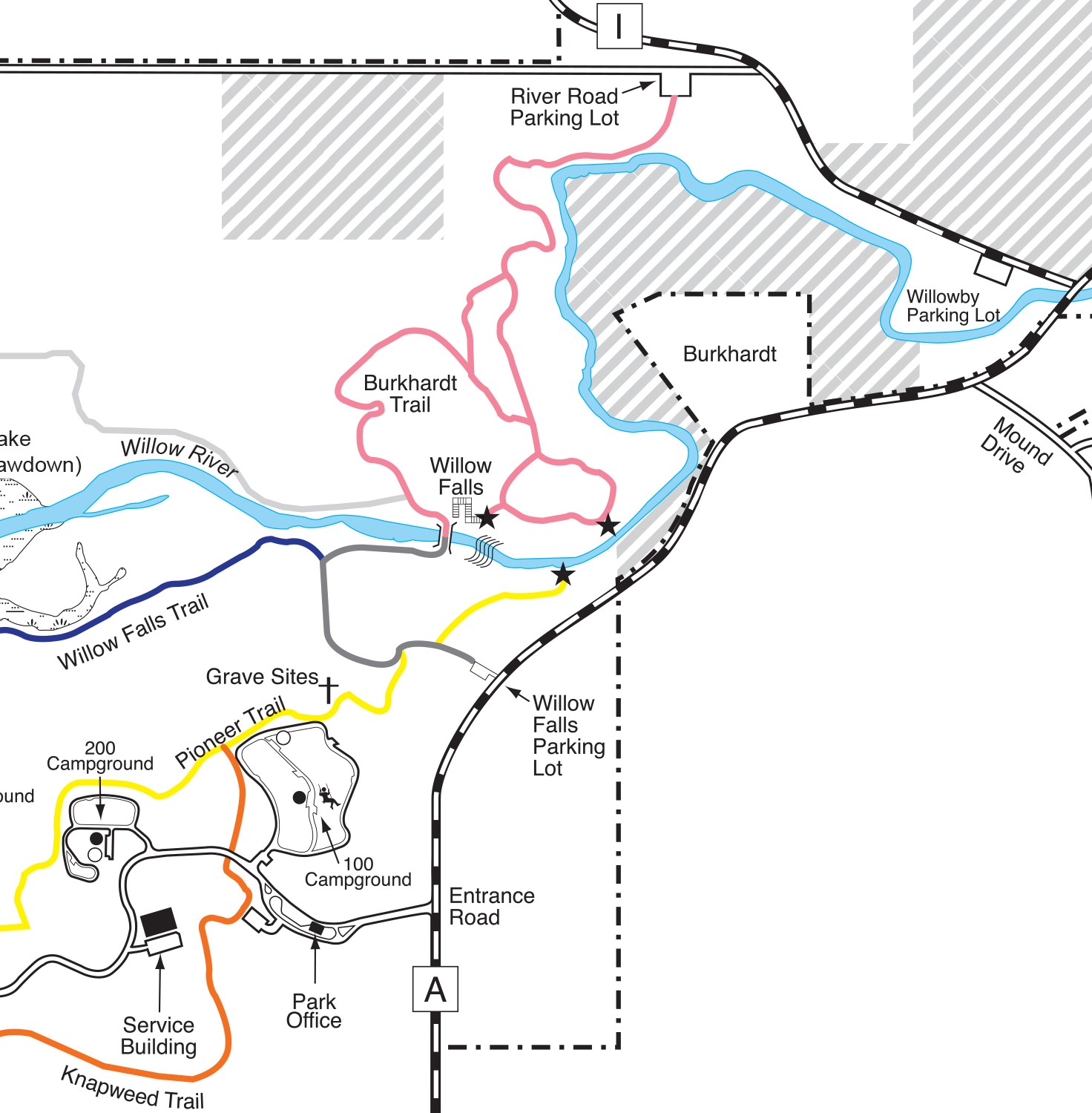
Next, the path intersects and ends at the Burkhardt (Pink) Trail. Walk a few hundred feet south and down a stairs on the Burkhardt, though, and at the footbridge you’ll come to Willow Falls, a set of cascades that drops 45 feet with gorge walls rising 200 feet above the water.

The route on the south side of the bridge is the Willows Falls Hill (Gray) Trail.

Learn more about nearby day hiking trails in my Day Hiking Trails of St. Croix County guidebook.


Wednesday, September 17, 2014

Hill trail leads to one of WI's top waterfalls

Willow Falls from the Willow Falls Hill (Gray) Trail.
Willow Falls Hill (Gray) Trail

Willow Falls Hill
(Gray) Trail runs
0.85-miles total


A waterfall that many say is among Wisconsin’s best awaits day hikers on the Willow Falls Hill (Gray) Trail.

The trail runs about 0.85-miles round trip on Willow Falls State Park’s eastern side. Late spring and June mark a great time to hike the trail, as the falls will be in full flow, especially within a day or two of a rainfall.

To reach the trail, take Exit 4 from Interstate 94, heading north on U.S. Hwy. 12 for about 1.6 miles. Follow County Road U for 0.3 miles to County Road A. Drive north, continuing past the main park entrance for about 0.4 miles. Park in the Willow Falls Parking Lot on the road’s left/west side. The trailhead leaves from the lot’s northwest corner.

Field and woods
For the first 300 feet or so, the trail crosses an open field. Swaths of this region were prairie before settlers arrived, and park officials are allowing this section to return to that natural condition.

In the field, the first trail intersection heads north to an overlook of Willow Falls. Though a scenic view, instead continue straight/west to the falls’ base.

The trail enters a wooded area, where it reaches a second intersection, for the Pioneer (Yellow) Trail, which heads to the 100 Campground. Watch the trail markers to make sure you stay on the Willow Falls Hill (Gray) Trail.

Following the intersection, the trail descends a steep hill, taking you into the river valley. Early in the morning and at dusk, you stand a good chance of spotting whitetail deer, eagles, squirrels and chipmunks.

At the hill’s bottom, the trail veers north and intersects the Willow Falls (Blue) Trail. Again, watch for the gray trail markers and head north and then east.

By this point, you’ll hear the roar of the falls and will come alongside the Willow River, as it flows toward the St. Croix River.

In a little more than a hundred feet, the trail arrives at a wooden footbridge that crosses the Willow, and the falls comes into full view.

200-foot high walls
The Willow River ultimately descends 45 feet over the falls. The main drop is about 15 feet high but more than a hundred feet wide.

A sandstone gorge nestles the falls beneath 200-foot high walls. Geologists estimate the rock at the bottom of the gorge is about 600 million years old and have found trilobite fossils in it.

While the best vistas of the falls and gorge are on the bridge, also cross to its north side, where you can walk down onto the rocks alongside the gorge walls and get a bit closer to the falls. Be careful of slick rocks and small pools that can make the walk slippery and even get your shoes and socks wet.

The trail heading north from the bridge is the Burkhardt (Pink) Trail. It heads through a wooded river valley.

After taking in your fill of the falls and gorge, retrace your steps back to the parking lot. Though the trail’s short length is seemingly ideal for young children, a steep hill to climb back up after the excitement of seeing the falls will be anticlimactic (pun intended), so before taking this route, make sure kids are physically fit or that you’re willing to carry them. A bench along the way does allow for a convenient rest break.

Learn more about nearby day hiking trails in my Day Hiking Trails of St. Croix County.


Sunday, January 12, 2014

Diverse array of trails await at Willow River

Willow Falls, Willow Rivers State Park
Photo courtesy Wisconsin DNR.
Day hikers will find several excellent trails – including several to a scenic waterfall – at Willow River State Park outside of Hudson, Wis.

To reach Willow River State Park, take Exit 4 from Interstate 94, and head north on U.S. Hwy. 12 for about 1.6 miles. Go County Road U for about 0.3 miles to County Road A, where you’ll continue for another 1.5 miles. The park’s entrance is on the road’s left side. Some trails listed here are best reached from other park entry points, however.

The state park’s trails include:
g Burkhardt (Pink) Trail A walk alongside a scenic river, Willow Falls, and some impressive overlooks await hikers on this trail, which actually is three miles of connecting paths. It’s also known as the Pink Path because of its color on state park maps.
g Hidden Ponds Nature (Black) Trail The half-mile interpretive loop is paved, level and out of the wind, ideal for young children. The walking path is right next to the park’s nature center and a short stroll to the park’s swimming beach.
g Knapweed (Orange) Trail The trail runs for 0.9 miles one-way alongside an effort to restore prairie as it existed in Wisconsin before pioneers arrived during the 1800s. Among the plants you may notice – especially in late June to early July when it blossoms – is the purple knapweed, the trail’s namesake but unfortunately an invasive species that actually threatens the prairie and other ecosystems.
g Little Falls (Green) Trail – The 0.7-mile paved trail rambles alongside a Little Falls Lake between Little Falls Dam and the campground. A variety of waterfowl can be spotted from it.
g Mound (White) Trail – Located in an often overlooked section of the state park, the 1.1-mile Mound Trail offers views of the Willow River and a glacial mound (a hill that resisted erosion during the last Ice Age) on the opposite shore.
g Nelson Farm (Silver) Trail The state park’s newest trail opened in summer 2012. The 3.7-mile trail heads from a bridge on the Trout Brook (Purple) Trail through several ecosystems to the lake’s north side.
g Oak Ridge (Brown) Trail – Hikers can learn about geological features created during the last ice age on this 1.1-mile trail. It heads from the beach through hardwood forests.
g Pioneer (Yellow) Trail – Among the best views of Willow Falls can be seen from an overlook on the 1.2-mile trail. It also passes the gravesites of the area’s first white settlers.
g Trout Brook (Purple) Trail This 1.4-mile loop takes hikers through red pine stands and open prairie. You’ll be able to spot great blue heron, ducks and snapping turtles along the way.
g Whitetail (Red) Trail – Expect to spot at least the tracks of whitetail if not the graceful deer itself on this 0.7-mile trail. The path cuts across open fields and along a forest’s edge.
g Willow Falls Hill (Gray) Trail – The quickest way to reach beautiful Willow Falls is this 0.4 trail. The downside is the hill is quite steep, which may not be ideal for very young children.
g Willow Falls (Blue) Trail – An easier but longer trail for reaching the waterfalls is this 1-mile route. It follows the Little Falls Lake and Willow River shoreline to the falls.

Read more about day hiking the scenic riverway in my guidebook Hittin’ the Trail: Day Hiking the St. Croix National Scenic Riverway.


Saturday, November 16, 2013

Knapweed Trail skirts prairie restoration

Knapweed (Orange) Trail
Knapweed (Orange) Trail map

State park path rambles nearly
2 miles alongside meadow


Say “Wisconsin” and one usually doesn’t think “prairie.” But much of the southern portion of the state actually is part of the Great Plains, as are segments of three counties along the Minnesota border. Most of the state’s grasslands were quickly plowed under and converted to agriculture when pioneers arrived, however.

At Willow River State Park, just four miles from the Minnesota borders, day hikers can head alongside a project aimed at restoring some of that missing prairie. The Knapweed Trail, also known as the Orange Trail because of its color on park maps, runs for 0.9 miles one way.

Close to metro area
To reach the trail, from Interstate 94’s Exit 4 take County Road U north. In about two miles, County Road U ends at County Road A; go right/northeast at this junction. The park entrance road is another two miles on the left/west. After entering park, take the entry road past the park office, the roads to 100 Campground and 200 Campground, and one to the service building. At the Group Camp, turn left/south into the asphalt parking lot; if full, there is a gravel overflow lot on the road’s north side (If taking the Pioneer Trail loop option, at the hike’s end, you'll return to the gravel lot.).

The trailhead is immediately to the east of the parking lot road. A set of three trails are on the road’s south side; take the center one.

The trail heads through about 200 feet of woodland. In another 200 feet or so, you’ll reach a T-intersection. Turn left/east.

Restored prairie
From there, the trail skirts an old field being restored as prairie. Once returned to grassland, a variety of plants native to Wisconsin will dominate, including big and little bluestem, Canada wild rye, Indiangrass, junegrass, needlegrass, northern prairie dropseed, sideoats, switchgrass, and woolgrass. You’ll also be able to see a number of forbs, or flowering plants that aren’t grasses.

Among the plants you may notice – especially in late June to early July when it blossoms - is the purple knapweed, the trail’s namesake. Unfortunately, knapweed is an invasive species that actually threatens the prairie and other ecosystems.

Native to Eastern European, knapweed probably came to North America in the 1800s via alfalfa shipments. In 1980, it was found in a mere 26 Pacific Northwest counties – but just 20 years later it was in 45 states, including Wisconsin.

Knapweed likes dry areas, such as prairies, and usually takes roots in disturbed areas such as former farm fields. Its roots exude chemicals that prevent other plants from growing.

Owl calls
After a little more than a third of a mile walking alongside the prairie restoration area, the trail veers north back through woodlands between a service building and the park headquarters. If hiking near sunset, listen for great horned owls calling in the pine trees.

In a little more than a quarter mile, the trail crosses the park entry road, so watch for traffic. Then, about a fifth of a mile later, you’ll reach the trail’s end at the Pioneer (Yellow) Trail junction. The 100 Campground is to your right/east.

You have two options here: Go back the way you came or make a loop of it by taking the Pioneer Trail left/west. The Pioneer Trail is the shorter way to go by about a third of a mile; it heads through woodland, edges the north and west sides of 200 Campground, and then comes to the gravel parking lot immediately north of the lot containing your vehicle.

If treating the Knapweed as an out-and-back trail, the hike runs 1.8 miles round trip. The Knapweed-Pioneer loop is about 1.5 miles.

Learn more about nearby day hiking trails in my Day Hiking Trails of St. Croix County.


Friday, October 11, 2013

Enjoy nature walk at Willow Falls state park

Hidden Ponds (Black) Nature Trail
Hidden Ponds (Black) Nature Trail map

Loop circles nature center near swimming beach


Families can enjoy a fun day of discovering nature with a hike on the Hidden Ponds Nature Trail at Willow River State Park in Hudson, Wis.

The half-mile interpretive loop is paved, level and out of the wind, ideal for young children. Also known as the Black Trail (because of its color on park maps), the walking path is right next to the park’s nature center and a short stroll to the park’s swimming beach.

Trailside blackberries
To reach the trail, from Interstate 94’s Exit 4 take U.S. Hwy. 12 north. Go straight/north at the County Road U intersection. In about two miles, County Road U ends at County Road A; go right/northeast at this junction. The park entrance road is another two miles on the left/west. Follow the park road to the nature center parking lot. It’s about a half-hour drive from downtown St. Paul, Minn.

The trailhead is next to the nature center at the parking lot’s southeast corner. A small stem takes you to the main loop.

Be sure to pick up a guide at the trailhead. Numbered posts run all along the trail, providing great opportunities to teach children to learn about the oak forest and wetlands they’re passing through.

If quiet, you’ll probably spot whitetail deer along the trail, especially at dusk. Songbirds also are plentiful. In mid-September, blackberries can be found trailside.

Wildflower garden
After completing the loop, stop in the nature center. Various displays and exhibits focus on west-central Wisconsin’s natural and cultural history. A wildflower garden just outside the center offers 20 common species – such as black-eyed Susan, blazing star, and New England aster – and some of them almost always are in bloom from spring through autumn.

If heading to the park during summer, check online to see what programs are planned at the nature center. The center is open year around. Also, be forewarned: the nature center has a gift shop.

After the nature center, make a full day of it with a walk over to the Little Falls Lake swimming beach, just a few dozen feet northeast of the parking lot. Be sure to pack bathing suits, towels, and sand toys.

A final note: Leashed pets are not allowed on the Hidden Ponds Nature Trail, though they may be taken on other park trails.

Read more about day hiking the scenic riverway in my guidebook Hittin’ the Trail: Day Hiking the St. Croix National Scenic Riverway.


Saturday, June 16, 2012

Day trail heads to impressive Willow Falls

Falls on the Willow River at Willow River State Park.

Water tumbles over
600 million-year-old rock
at Willow River State Park


Walking alongside a scenic river, a waterfall, and some impressive overlooks await hikers on the Burkhardt Trail in Willow River State Park near Hudson, Wis.

The trail actually is three miles of connecting paths. It’s also known as the Pink Trail because of its color on state park maps.

To reach Willow River State Park, take Exit 4 from Interstate 94, heading north on Hwy. 12 for about 1.6 miles. Take Hwy. U for about 0.3 miles to Hwy. A, where you’ll continue for another 1.5 miles. Pass the park’s entrance on the road’s left side and turn left onto on Hwy. I. Take a left onto River Road (aka 115th Avenue) and then make a quick left into the River Road parking lot (You’ll need to pay an entrance fee or sport an annual state park pass.). The trailhead is on the parking lot’s south side.

Butterflies, dragonflies
The path begins by heading southwest along the Willow River bottoms. The marsh-like region boasts tall grasses and during summer a number of wildflowers. Watch for whitetail deer in the brush, eagles soaring overhead, and during summer butterflies and dragonflies flitting about. Frogs and a variety of birds also are abundant along the riverfront.

Upon coming to the first fork, go left into a wooded area. The trail then crosses a large meadow. Aspen, oak, maple and of course willow trees abound. At the next fork, again go left. You’ll head onto a bluff to an impressive overlook of the waterway and the gorge it has cut.

The trail then heads downward. At the next fork, veer left for the multi-level Willow River Falls. The rock on the gorge walls’ lowest levels is about 600 million years old.

You can take a stairwell about 100-feet down to the falls. Sometimes you’ll catch people wading through the falls; this is not advised for small children.

Wood footbridge
You can treat the trail to the falls as a spur and simply head back the way you came, or you can continue onward. If doing the latter, cross the wood footbridge over the river, but then turn back or you’ll find yourself on another trail on the wrong side of the waterway!

Upon turning back, the trail meanders northward but ultimately forms a loop.

At the next trail intersection, go left. You’ll then be heading back to the parking lot. At the next fork, turn left again, and you’ll find yourself on the trail winding along the river bottoms, which is where you started.

Depending on whether or not you turned around at the falls, the hike ranges from 2-4 miles in length. The park is open every day of the year from 6 a.m. to 11 p.m.

Read more about day hiking the scenic riverway in my guidebook Hittin’ the Trail: Day Hiking the St. Croix National Scenic Riverway.