Showing posts with label Manitowoc County. Show all posts

Thursday, September 30, 2021

Top fall trails in east-central Wisconsin, Pt. II

Parnell Tower Trail, Kettle Moraine State Forest, Wisconsin
There’s no better way
to experience autumn colors around east-central Wisconsin than
a hike.

The brilliant yellows, oranges and red of maples to the scarlet
and russets of oaks...
the crisp, fresh autumn air and the last warm rays of sunlight before winter arrives...the crunch of fallen leaves and acorns beneath your boots...stopping to enjoy a warm mug of apple cider or a caramel apple pulled from your backpack – it all calls for an afternoon on the trail.

Fortunately, there are plenty of great autumn trails around east-central Wisconsin to hike. Some are right out your back door, while some are a day trip that you can do in an afternoon.

Manitowoc County
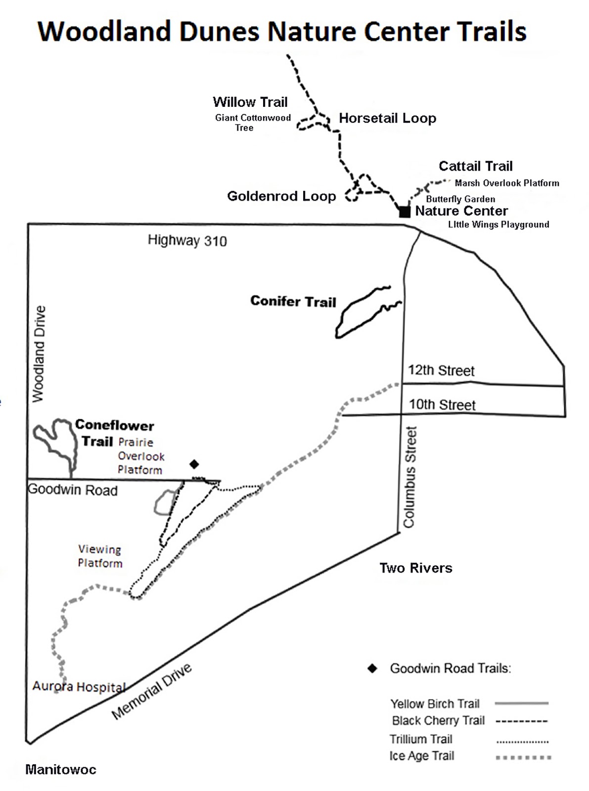
Hikers can walk upon what 5000 years ago was a Lake Michigan beach ridge. Entirely wooded now, it makes for a great autumn hike. The 0.5-mile Conifer Trail at Woodland Dunes Nature Center and Preserve sits near the great lake between Manitowoc and Two Rivers. Signs along the trail point out the different types of trees, which make a splendid autumn display – the bronze of American beech, the yellows, oranges and reds of sugar maple, the brown of red oak and the scarlet of white oak, all mixed with the olive leaves of basswood and evergreen needles of the conifers. From Manitowoc, take Wis. Hwy. 42 north or from Two Rivers follow the highway south. Go north onto Columbus Street and left/west onto Wis. Hwy. 310. Immediately after Columbus Street, turn right/north into the preserve’s nature center and park there. To reach the trailhead, head south alongside Columbus Street; a sign identifies the trailhead, about two blocks from the nature center, on the road’s west side.
***
A walk through an oak forest up an ancient kame awaits day hikers on a section of the Ice Age National Scenic Trail. The 2.3 miles (one-way) Walla Hi segment winds to the top of a 975-foot high kame then back down to a plain. Tan and russet oak leaves, accented by the yellow of various birches and the dark green of pines, line the route between Walla Hi County Park and Lax Chapel Road. From Kiel, take Wis. Hwy. 32 east/south. Turn left/north onto County Road MC/South Cedar Lake Road then left/west into Mueller Road. Park in the lot at the end of Mueller Road. Head south/west on the trail.
***
Yellow and orange leaves along a pretty river await hikers on the Henry Schuette Park segment of the Ice Age National Scenic Trail in Manitowoc. Half of a 1.2-mile loop runs along the wooded Manitowoc River before the waterway spills into Lake Michigan. From U.S. Hwy. 151 in Manitowoc, go north on South 35th Street. Turn left/west onto Meadow Lane, which becomes Broadway Street when it curves north. Park at the playground then take the sidewalk along Broadway north. The trailhead is on the street’s right/east side. Check ahead to ensure the trail is not closed due to high water levels.

Outagamie County
A pretty hike through a woods to an observation tower overlooking a pond awaits at the Gordon Bubolz Nature Preserve. The hike to and on the Deer Run Trail goes for about 4 miles in a loop. During autumn, you’ll enjoy golden red prairie grass while the forest boasts bronze beech accented by the oranges and reds of sugar maple, the amber of basswood, and the russet of red and white oak. The observation tower takes you a story above the terrain and Black Acres Pond. From Appleton, head out of town north on N. Lynndale Drive/County Road A. The road to the nature preserve is on the left/west. Once parked, pick up a trail map at the nature center, as you’ll need to hike segments of other routes to reach the Deer Run Trail.

Sheboygan County
Day hikers can head to an observation tower on the Kettle Moraine State Forest’s highest point via a short trail. In autumn, the walk through the surrounding forest and the view of it from the tower is a fantastic sight. The 0.7-mile out and back Parnell Tower Trail heads to the 60-foot wooden Parnell Observation Tower. The hike can be lengthened, though, by adding a loop, known as the Parnell Tower Trail Loop, which runs 2.9 miles. The hike to the tower heads beneath a canopy of maple trees while northern red oak, basswood, sugar maple and white ash dominate another part of the hill. From Plymouth take Wis. Hwy. 67 west. Turn left/south onto County Road A (aka Kettle Moraine Scenic Drive). County Road U joins County A from the east; in just under 2 miles when County Road U goes right/west, turn onto it. In about 0.15 miles, turn right/north into the parking lot for the trail. A gravel trail – the short stem leading to the loop – heads north from the lot’s northern side.
***
Hikers can head through a 130-year-old forest at the Kettle Moraine Red Oaks State Natural Area. The remains of a half-mile pack trail (1-mile round trip) runs through the northern section of the forest, where more than 100 trees, shrubs and herbs can be found. In autumn, the red oak-dominated forest is colorful as basswood, sugar maple, white ash, big-tooth aspen, white oak, black cherry, and shagbark hickory offer a variety of harvest hues. From Plymouth, take Wis. Hwy. 23 west. Turn left/southwest onto Plank road and then left/southeast onto Cemetery Lane. Park at the end of the lane, which marks the state natural area’s border.

Winnebago County
Hikers can enjoy an array of autumn colors along a comely stream at Waukau Creek County Nature Preserve. The 0.55-mile Elderberry Trail loops through a small part of the preserve and includes a connector that goes to Waukau Creek and two other footpaths. Along the way is wine-red-leaved white oak, yellow-colored bitternut hickory and prickly ash, gold to maroon white ash, burgundy northern red oak, crimson smooth sumac, and orange-brown box elder. From Oshkosh, take Wis. Hwy. 44 southwest. Turn right/west onto Wis. Hwy. 91 then right/north on Wis. Hwy. 116. In Waukau, go left-straight/northwest onto Delhi Road/20th Street. The parking area is on the road’s left/west side with the trailhead on the road’s opposite side.
***
A variety of autumn colors can be enjoyed at the North High Conservancy Park next to Oshkosh North High School. Just under a mile of bark trails ramble through the 12.19-acre natural area that is mostly woods with a couple of small ponds. The trees range from immense old hardwoods to thin new birch growing in the wetter sections. Volunteer efforts are underway to remove buckthorn and garlic mustard from the park. From the junction of U.S. Hwy. 45 and Wis. Hwy. 44, take the former north. Turn left/west onto West Smith Avenue then right/north on Vinland Avenue and finally right/eat onto Morgan Avenue. A trail runs north from the high school parking lot. When school is in session, park instead on an adjoining street.


Thursday, September 23, 2021

Wis. autumn hikes abound on Lake Michigan

Seven Bridges Trail in Milwaukee.
If living in or traveling 
to a Wisconsin county
along Lake Michigan, plenty of great autumn trails await.

Eleven Wisconsin counties border Lake Michigan – including Green Bay. Maple and beech dominate most forests near the lake,
but several other trees can be found as well. Here are some solid autumn leaf hikes in those counties from south to north:

Kenosha County
Among the best places to see fall colors are streams, where the leaves reflect beautifully against the blue water or brighten a gray sky. Such is the case at Petrifying Springs Park, where an unnamed trail traverses 2 miles (round trip) through a woods and alongside Pike River in the park’s southwest corner. Be sure to take the side trails with footbridges crossing the river, where you can enjoy orange and yellow leaves on trees and shrubs, some of them falling into the water and slowly gliding downstream. In Kenosha, from Wis. Hwy. 31 exit east onto Berryville Road/7th Street. Take the second right/south. Drive 0.17 miles to the second parking lot. Pick up the hiking trail from the paved sidewalk on the lot’s west side, going southwest into the woods.
***
Hikers can experience the richly colored orange-red leaves of the hawthorn tree that grows along Pike Creek near Kenosha. The 0.4-mile looping Hawthorn Trail runs in the Hawthorn Hollow Nature Sanctuary and Arboretum. Hawthorns grow from 16 to 49 feet tall, and when more shrub than tree-like, their leaves branch out all around the trunk from the ground to its top. A bonus in autumn: The woods is a major stopover for migrating songbirds. From Kenosha, head north on Wis. Hwy. 31. After crossing Somers Road, turn left/west into the nature sanctuary. Park at the nature center; the trail begins west of it.

Racine County
Day hikers can walk across what used to be a terrace of ancient Lake Michigan and now is a wonderland of harvest colors in autumn. A 1-mile nature trail loops through Sanders Park Hardwoods State Natural Area, which is located within Sanders County Park. Among the highlights are gold-leaved basswood, wine-red white oak, bright-yellow black walnut, russet-colored red oak, lemony white ash, and a brilliant yellow elm-ash stand. From Racine, take Taylor Avenue south. Turn left/southwest onto Wood Avenue then right/east onto Exculpating Road where there’s a parking lot.
***
Hikers can enjoy a bird sanctuary undergoing a major transformation at Colonial Park in Racine. The 1-mile round trip Root River Pathway makes two crossings over the waterway on its way to Lincoln Park. Many rare warblers stop in the park during the fall migration. An extensive effort is underway in the park to eliminate invasive species, such as buckthorn, reed canary grass, and garlic mustard, and to restore wetlands as well as replace ash trees ravaged by emerald ash borer. In 2019, a total of 175 small trees – birch and oak – and shrubs – elderberry, hazelnut, chokeberry and nannyberry – were planted in the park’s southern section, making for a great walk in which fall colors are at eye level. From downtown, take State Street west. Turn left/west onto West High Street. The road ends in the park.

Milwaukee County
Day hikers can traverse a wooded ravine with great views of Lake Michigan at Seven Bridges in Grant Park on Milwaukee's South Shore. The 0.4-mile round trip Seven Bridges Trail, with its stone steps and footbridges, makes for a great autumn hike. Along the way are yellow-leafed American beech and birch, amber-, orange- and red-colored maples, and gold to maroon white ash. From the junction of Interstates 94/41 and College Avenue, take the latter east. Go right/south onto South Lake Drive then left/east onto Grant Park Drive. Park in the spaces off the road at the Seven Bridges Trailhead.
***
An observation tower offers great views of Lake Michigan and 185 acres of forest right in the Milwaukee metro area. The 0.26-mile Green Tree Accessible Loop at the Schlitz Audubon Nature Center heads through a woods of beech, sugar maple, basswood and red and white oak. On the loop’s northeast side is a 60-foot high tower that you can go to the top of. From Interstate 43, head east on E. Brown Deer Road. Turn right/south onto E. Bay Road and into the center. Park in the lot at the road’s end. Walk east from the road to the trailhead.
***
Autumn colors with a view of Lake Michigan awaits at Big Bay Park in Whitefish Bay. A short 0.44-mile round trip path heads along the tree line, atop the bluff, while another heads to the Lake Michigan shore, where there's a concrete pier. In fall, yellow-, olive- and russet-colored leaves brighten the walk. From the intersection of Interstate 43 and West Hampton Road, take the latter east. Turn left/north onto North Lake Drive then right/north onto North Palisades Road. Park on the street.

Ozaukee County
Migrating raptors and fall colors set against the backdrop of beautiful Lake Michigan await at Lion’s Den Gorge Nature Preserve. After passing a wetlands popular with waterfowl, the 2-mile round trip Lion’s Den Trail enters a deep, verdant gorge. Aspen stands and mature white birch with their fluttering yellow leaves abound. The trail then delivers you to a long, secluded beach. From Port Washington, drive south on County Road C/Lake Shore Road. Turn left/east onto High Bluff Drive, which enters the park. When the road becomes a roundabout, park in the first/southern lot.

Sheboygan County
The brilliant colors of sugar maples await hikers at the Maywood-Ellwood H. May Environmental Park in Sheboygan. The 0.25-mile Maple Forest Loop runs through the 135-acre city-owned park. each autumn, the maples' leaves turn amber, orange and crimson. Watch for whitetail deer and the many songbirds that call the park home. From Interstate 43, take exit 128 onto Wis. Hwy 42 and go southeast. Turn right/west onto Mueller Road. Park entrance is on the left/south. The trail leaves from the sugar house next to the Ecology Center.

Manitowoc County
Yellow and orange leaves along a pretty river await hikers on the Henry Schuette Park segment of the Ice Age National Scenic Trail in Manitowoc. Half of a 1.2-mile loop runs along the wooded Manitowoc River before the waterway spills into Lake Michigan. From U.S. Hwy. 151 in Manitowoc, go north on South 35th Street. Turn left/west onto Meadow Lane, which becomes Broadway Street when it curves north. Park at the playground then take the sidewalk along Broadway north. The trailhead is on the street’s right/east side. Check ahead to ensure the trail is not closed due to high water levels.

Kewaunee County
A pretty fall hike along a river awaits on a segment of the Ahnapee State Trail. The 2.25-mile round trip rail-trail between County Road M and Washington Road sits in the Ahnapee River’s wetlands cooridor where migrating birds gather each autumn amid the bronze grasses. On higher ground, look for the willows’ shimmering gold leaves in the breeze, dogwoods’ deep scarlet leaves and berries, and bog birch’s amber. From Algoma, take County Road M north. The parking lot is on the northeast corner of where the the road and trail meet.

Door County
Hikers can enjoy majestic views of blue Green Bay and the yellow and orange leaves of a blufftop forest at Ellison Bay Bluff County Park. An unnamed 1-mile trail loops through a woods of sugar maple, white ash, red oak, birch and beech. A spur trail leads to an observation deck at the edge of the 100-foot high limestone bluff. An enclosed catwalk extends outward from the bluff; walking on it will make you feel like you’re flying. From Ellison Bay, take Wis. Hwy. 42 south. Turn right/west onto Porcupine Bay Road then right/north onto Ellison Bluff Road. The road loops through the park; leave your vehicle in the lot on the loops’ southwest side.

Brown County
Hikers can head through a remnant of the great oak forests that once covered all of Brown County. The 1.15-mile round trip McMahon Woods Trail sits in the Cofrin Memorial Arboretum, which surrounds the UW-Green Bay campus. The trail runs alongside McMahon Creek, which flows into nearby Green Bay. Russet-colored oaks dominate the McMahon Woods' uplands while colorful sugar maples can be found in the understory. Fifty-nine different trees and shrubs can be seen along the trail. From Wis. Hwy. 57, take Nicolet Drive north. Turn right/southeast onto South Circle Drive. Roadside parking is available along the road’s first curve.
***
A grove of cottonwoods awaits hikers on the Woodcock (Blue) Trail at Barkhausen Waterfowl Preserve in Suamico. The 0.75-mile trail heads north from the interpretive center and curves around a small pond in the preserve’s northwest corner. During autumn, it’s a gloriously beautiful walk, as the tall eastern cottonwoods – which are largely absent in this part of Wisconsin – turn a bright yellow. From U.S. Hwy. 141 in Suamico, take Lineville Road east. Turn left/north onto County Road J/Lakeview Drive and then right/east into the preserve. Park at the center.

Oconto County
Hikers can head to the county’s highest point for great views of the surrounding forest. The 1.3-mile Butler Rock Trail climbs 160 feet to 1093 feet above sea level. It includes a 0.7-mile spur trail that stays at ground level as circling to the face of Butler Rock in Chequamegon-Nicolet National Forest. The newly developed trail crosses a forest whose canopy in autumn turns orange, red and yellow-green. From Wis. Hwy. 64 south of Mountain, take Old Hwy. 64/Forest Road 2308 east. Turn left/north onto Butler Rock Road then left/northwest onto Butler Lookout Lane. The trail starts where the road ends.
***
Day hikers not bothered by heights can enjoy a spectacular vista of autumn leaves from Mountain Lookout Tower. The 0.26-miles round trip hike sits in the vast Chequamegon-Nicolet National Forest. The tower is at an elevation of 1,254 feet. The road heads through a classic Northwoods setting that is beautiful any time of the year but particularly so in autumn. A September walk takes you past sugar, red and mountain maples, white, red and black oaks, paper, yellow and river birch, aspen, beech, basswood, and sumac. Various green conifers – including pine, spruce, fir, and juniper – dot the hardwood forest. From the village of Mountain on County Road W just east of Wis. Hwy. 32, take National Forest Road 2106 (Old 32) north. In about 2.25 miles, turn right/southeast onto Mountain Tower Road. Pull off to the side of the road so you’re not blocking traffic. Hike the road up to the tower.

Marinette County
A walk through a forest in the state’s rare Northeast Sands eco landscape awaits hikers at Governor Thompson State Park. The 3.5-mile Forest View Trail loops through a forest of yellow-leafed aspen, orange and red maples, and marigold scrub oak dotted with evergreen jack pine and hemlock. Less than 3 percent of Wisconsin falls into the sands eco landscape. From Crivitz, take County Road W west. Turn right/north onto Parkway Road then left/west onto Ranch Road. Enter the parking by going right/north on Paust Lane. Park in the lot for Woods Lake and walk north alongside Paust Road to the trailhead.


Wednesday, May 16, 2018

Trail crosses ancient Lake Michigan beaches

Point Beach with Rawley Point Lighthouse. Wisconsin DNR photo.
Point Beach Ridges Trail map.
Click for larger version.
Day hikers can walk along the ridges and swales of a secluded Lake Michigan beach on Wisconsin’s Rawley Point Ridges Trail.

The 5-mile round trip trail runs through beautiful Point Beach State Forest. Part of the route is a segment of the Ice Age National Scenic Trail. Nearly 1200 miles long, the Ice Age Trail traces the edge of where glaciers stood at the end of the last ice age in Wisconsin.

To reach the trailhead, from Two Rivers take County Road O north. In about five miles, you’ll reach the state forest entrance; turn right/east into the forest. Park at the entrance station. From the parking lot, walk the entrance road west for about 140 yards then go left/south onto the Ice Age Trail.

The narrow, almost primitive footpath heads atop a forested sand ridge through a cedar grove. On the trail’s right is a swale.

Swales are marshy depressions between ridges that parallel the shoreline. There are several of them at Point Beach. They formed at the end of the last ice age when lake levels were higher. As creeks deposited sediment into the lake, wave action created a series of beaches matching the current shoreline. As the lake level gradually fell, the beaches were left behind as ridges with low-lying marshes in between. Grasses, shrubs and trees then stabilized the ridges while water pooled in the swales.

Headin’ to the beach
At 0.7 miles, the trail reaches the start of the Red Loop. Go left/southeast onto it. The Red Loop – as well as the next two, the Blue and the Yellow – are three ski trails rambling through the hardwood and cedar forest here.

When the trail curves south at 0.8 miles, a spur leads to the beach and a camping site for kayakers. If you wish to only walk the beach, take the spur. Within a few feet, about six miles of undeveloped beach stretch before you. The secluded beach makes for a beautiful moonlight walk as Lake Michigan’s waves crash against the shore.

Alternately, you can keep sand out of your shoes and stay on the recreation trail. If you do, the trail next junctions with the Blue Loop. Go left/southeast onto the Blue Loop’s eastern or beach side.

At 1.9 miles, the trail crosses the road to the Group Camp. This places you on the Yellow Loop’s eastern leg.

Molash Creek
As the Yellow Loop curves west at 2.5 miles from the trailhead, you’ll be able to spot Molash Creek between the trees. This marks a good spot to pause, as there’s a bench to take in the small waterway. Continuing on, the loop briefly parallels the broad and marshy creek.

When the Ice Age Trail and Yellow Loop split at 2.8 miles, go right/northeast on the loop. Once you cross the road leading to the Group Camp; you’re on the Blue Loop’s western leg.

Upon reaching the Red Loop, continue left-straight/northeast on the loop. The way back is on a slightly higher ridge than the one you walked in on.

In addition to cedars, red pines and spruce can be found in the forested area. Cattails and marsh reeds often line the swales. Raspberry bushes and ferns can be found along the route as well.

Rawley Point Lighthouse
When the Red Loop meets the Ice Age Trail at 4.6 miles, go left/northwest into it. Once a bike trail joins the path from the left, the hiking surface turns to crushed limestone.

Upon reaching the entrance road, take the road right/east. In about 100 feet, you’ll pass the trailhead. Continue on the road back to your vehicle.

Once back at the parking lot, drive east on the park road and check out the Rawley Point Lighthouse. The 113-foot steel tower still operates and can be seen up to 19 miles away. Constructed in 1894, it replaced the 1853 brick lighthouse that was refurbished as the lightkeeper’s house. The lighthouse generally is no open to the public but still makes for a pretty sight. A dog trail runs from the lighthouse to the beach.

Definitely bring insect repellent for the trip, as the swales supports a vibrant mosquito and mayfly population. Dogs are allowed on the trail and beach if leashed, except during ski season. Always stay on the trail or the beach to avoid harming rare plants and the fragile dunes.


Sunday, February 11, 2018

Hike to one-of-a-kind Great Lakes lighthouse

Rawley Point Light and the keeper's residence on Lake Michigan.
Map of walk to Rawley Point Light. Click for larger version.
Day hikers can explore the grounds of the only skeletal lighthouse of its kind on the Great Lakes just north of Two Rivers, Wisconsin.

The walk to the Rawley Point Light is a brief 0.15-miles round trip. Access to a Lake Michigan beachfront also is available.

To reach Rawley Point, from the intersection of Wis. Hwy. 42 and County Road O (22nd Street) in Two Rivers, take County O east/north. After passing Point Beach State Forest, turn right/east onto Park Road. Leave your vehicle in the lot on the road’s right/south side just before it curves north. Go to the lot’s east side and walk the trail heading right/south.

After passing through a small grove, the trail opens up to the lighthouse grounds with the beach and Lake Michigan beyond.

Long history of lighthouses
Standing 113-feet high, the lighthouse isn’t your standard brick or sandstone structure that make up so many of Wisconsin’s charming light stations. This light instead is the octagonal skeletal structure of the 1859 Chicago Harbor Light, which was dismantled and then reconstructed on the point in 1894.

The lighthouse and point is named for Peter Rowley, who set up a trading post nearby in 1835. A 1888 government records misspelling of his name led to the current use of “Rawley” rather than “Rowley.”

Records are not entirely clear, but a 75-foot tall light consisting of four poles and a lantern is thought to have been erected on the site in 1853. A wooden tower and house was built soon after. Because the wooden tower was in a poor location, though, a brick structure was constructed in 1874. This tower proved to be structurally unsound, however, so it was replaced with the current lighthouse. Trusswork was added to the steel tower’s base to increase the height, a new service room below the lantern was built, and a better lens installed.

The current lighthouse effectively ended shipping accidents on the dangerous shoals around Rawley Point. Prior to it, 26 ships foundered or were left stranded on the point. In 1887, the steamship Vernon sunk nearby, drowning 36 crew members and passengers.

Name change
The lighthouse was known as Two River Point Light until 1956, when it was given its current name. In 1962, a fire destroyed part of the residence. Then in 1979, the lighthouse was automated.

It continues in service today with Coast Guard personnel using the residence. The light can be seen up to 19 miles away and operates a half-hour before sunset until a half-hour after sunrise.

Tours of the lighthouse are not available, but on occasion self-guided tours of the residence are.

After taking in the lighthouse grounds, feel free to walk to the beach and dip your feet into Lake Michigan’s cold waters. The beach stretches about 300 feet from the lighthouse to the lake, so this can at least double the distance of the hike to a minimum of 0.3-miles round trip.


Sunday, September 17, 2017

Trail crosses ancient great lake beach ridge

Autumn colors line the forest at Woodland Dunes Nature Center and Preserve.
Conifer Trail map. Click for larger version.
Hikers can walk upon what 5000 years ago was a Lake Michigan beach ridge in Wisconsin.

The 0.5-mile Conifer Trail at Woodland Dunes Nature Center and Preserve located near the great lake between Manitowoc and Two Rivers. Entirely wooded now, it makes for a great autumn hike.

To reach the trailhead, from Manitowoc take Wis. Hwy. 42 north toward Two Rivers. Turn left/north onto Columbus Street and left/west onto Wis. Hwy. 310. If in Two Rivers, take Hwy. 310 west toward Interstate 43. Immediately after Columbus Street, turn right/north into the preserve’s nature center and park there. To reach the trailhead, head south alongside Columbus Street; a sign identifies the trailhead, about two blocks from the nature center, on the road’s west side.

The looping trail follows two ancient beach ridges – elevated areas of sand and sediment swept there by waves. It crosses a swale – a low-lying area – between the ridges.

But how can there be beach ridges when Lake Michigan is more than a half-mile away?

These are ancient beach ridges and swales, remnants from a time with Lake Michigan was larger. In fact, it wasn’t exactly Lake Michigan then but Lake Nipissing.

As the heavy glaciers retreated some 10,000 years ago, the depressed crust of North America rebounded. The result was higher levels in Lake Nipissing, which is basically today’s Lake Michigan, except 30 feet higher. This inundated low-laying land to the lake’s east and south. Breaking waves bulldozed the lake’s sandy bottom, creating a series of parallel underwater ridges and troughs.

Gradually water drained from Lake Nipissing, and the shoreline retreated. As it did, those underwater ridges and troughs became above water sand dunes and swales. Plants common to beach dunes kept these ridges and depressions in place. Over the centuries, shrub carr replaced the dune plants, paving the way for forests to take root and grow.

Today, a mixed hardwood-conifer forest covers the Conifer Trail’s beach ridges and swale. Signs along the trail point out the different types of trees, with the hardwoods consistently mainly of beech, sugar maple, basswood, red and white oak.

That makes for a splendid autumn display – the bronze of American beech, the yellows, oranges and reds of sugar maple, the brown of red oak and the scarlet of white oak, all mixed with the olive leaves of basswood and evergreen needles of the conifers.

The beech trees are particularly interesting as they primarily grow in hardwood forests along Lake Michigan and are absent in most of the rest of Wisconsin. The American beech grows up to 60-75 feet high and boasts a broad, oval canopy. They prefer organically rich, acidic, loamy soils, common along Lake Michigan.

After completing the loop, walk left/north along Columbia Street and return to the nature center.


Wednesday, July 5, 2017

Short trail passes several bluffside caves

Entries to the Tartarus Cave System at Cherney Maribel Caves County Park.
Cherney Maribel Caves County Park map.
Click for larger version.
Day hikers can explore several caves along a bluffside at the Cherney Maribel Caves County Park in east central Wisconsin.

The 0.75-mile Bluff Trail runs past a variety of natural caves in a limestone cliff. Many of the caves here were discovered during the 1800s.

To reach the caves, from Interstate 43 take Exit 164 at Maribel and go east on County Hwy. Z. At County Hwy. R (aka N. Packer Drive), turn left/north. The park road will be on the right/east; follow it to the parking lot.

From the parking lot, take the Bluff Trail northwest atop an escarpment ridge that rises about 60 feet over West Twin River. The limestone formed some 419-443 million years ago when this section of the world was beneath a tropical sea. Shells of dying marine animals fell to the bottom of the sea floor and, over the eons, hardened into rock. Then, about 14,000 years ago, water rushing out of Glacial Lake Oshkosh down the West Twin River cut away the cliffside.

Since then, springs, carbonic acid, the changing seasons, glacial ice melt, and temperature variations have broken down the limestone, resulting in small caves and openings.

When the trail reaches a junction as heading down the bluff, go right/southeast. This leads to caves’ entries.

The first among them is the Maribel New Hope Cave, which was discovered in 1984 when steam came out of it. Talus blocking the entryway was removed, and on October 31, 1990, explorers removing sediment from a two-foot-high, 20-foot long passageway broke through to a cave room; it is now known as the Halloween Room. The largest of the park’s caves with stalactites and soda straws, it is open to the public only during special tour hours.

Continuing along the bluff’s base, the trail passes Pancake Cave. There’s no natural trail to it, and you have to climb over talus to enter it. The small solutional cave – meaning it was created by carbonic acid from groundwater dissolving the limestone – is about eight feet long and shaped like a pancake, hence its name.

The trail next comes to Coopers Cave, which is open to the public during park hours. A footpath heads up to a large, rectangular entrance. A square solution cave, it goes 20 feet deep and has two rooms that you’ll have to crouch in.

Just below the cave entrance is the Seepage, a moss-covered talus pile through which a natural spring flows. It flows year round, trickling down to the river.

The trail then swings away from the bluff to the river, briefly joins the River Trail, then circles back to the escarpment, passing the Millpond Dam, the small Cave of Treasures, and Watercress Spring along the way.

Among the best caves to explore at the county park comes next – the Tartarus Cave System. Its dramatic stone entrance is easy to spot. The cave system actually has three entrances. The passageways are still being explored and may link to other caves or sinkholes. This cave is open to only during special tour hours.

Next, take the stairs back up the bluff. Once at the top, follow the trail back to the parking lot.

Another cave associated with the bluff is the Spring Cave, which sits north of the Maribel New Hope Cave. A spring flows from the cave, and that water was used for drinking, cooking, and bathing at a hotel that sat near the site many years ago. The cave is on private property so cannot be entered.

The guided tours last 20-30 minutes each and are given select Sundays May through October from late morning to early afternoon. They are free. Caves open to the public can be toured anytime during park hours.