Sunday, February 25, 2024

Remote trail runs through organ pipe forest

Day hikers can see the rare organ pipe cactus and enjoy a great vista in south-central Arizona.
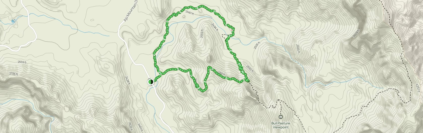
The 2.7-mile Bull Pasture and Estes Canyon Trails Loop – which can be extended to 3.7 miles – sits in Organ Pipe Cactus National Monument.

To reach the trailhead, from either Interstate 10 or 19 in Tucson, take Ariz. Hwy. 86 west. You’ll drive for more than 90 miles across the desert and through the Tohomo O’odham Nation Reservation. At the small town of Why, go left/south onto Ariz. Hwy. 85 to the national monument. Upon reaching the Kris Eggle Visitor Center, go right/east onto Ajo Mountain Drive, a one-way that eventually turns to a dirt road. Because of this, expect to drive for 40-50 minutes from the visitor center to the trail. The trailhead is at Mile 11; park in the sand pulloffs.

A small stem to the loop runs northeast from the parking area. Once at the loop, go right/east or counterclockwise and enter the Mount Ajo foothills.

The narrow path heads above a wash, crosses it, then climbs the canyon wall.

At 1 mile in, you can extend hike by going right/southeast up a ridge. In 0.4 miles, you turn right/south and head to a summit called Bull Pasture Viewpoint, so named because ranchers used to pasture their cattle there.

Mount Ajo
From the 3379-foot vista, you have a great view looking southwest into the desert and Mount Ajo to the northeast. Mount Ajo is the highest point in the monument at 4808 feet. The spur to the vista adds 1 mile to the hike.

Back on the main trail, at the spur junction your hike veers northwest and gradually ascends. Along the way, you’ll pass a number of the organ pipe cactus for which the national monument is known.

The organ pipe cactus is so named because it looks like an organ pipe. Those spiny pipes can grow up to 16 feet high. The cactus is exceptionally long-living, reaching maturity after 150 years. The plant grows only in southern Arizona and northern Mexico.

Its funnel-shaped white flowers open at night, when they can be pollinated by bats, and close in the morning. They typically bloom April through June.

Early April through May also is an excellent time to spot wildflowers. Among those you can see, especially after a rainfall, include Mexican gold poppy, desert lupine, purple owl’s clover, reddish-orange globemallow, yellow brittlebush and creosote.

Ridgeline
Atop the ridgeline, the trail passes some interesting rock formations. These formed from erosion as a block of heavy rock making up Mount Ajo rose while the basin below it sank as the land stretched, a common geological process during the past 70 million or so years across the West.

Next, the trail switchbacks down a steep slope into another wash.

At the wash, which is 1.6 miles from the trailhead (2.6 miles if you took the spur to Bull Pasture), you’ve reached the Estes Canyon and are on the Estes Canyon Trail, which crosses the dry run then parallels it.

You’ll loop back to the parking area, which is about a mile away from where you first reached Estes Canyon’s bottom.

The trail at times will be rocky and uneven, so be sure to wear hiking boots and bring a trekking pole. There’s also no shade, so be sure to don sunscreen, sunglasses and sunhat.

TOPO MAP
Click for larger, printable version

Thursday, April 20, 2023

Lizards, birds abound in Mecca Hills canyon

The colorful Great Basin collared lizard resides in
the Mecca Hills' many washes.
The following article originally was written for and appeared at Uken Report.

Day hikers can see dinosaur-like creatures in a remote canyon of California's Mecca Hills.

Well, that’s dinosaurs with an asterisk. But the forerunners of dinos – reptiles – as well their descendants – birds – are plentiful in Never-Ending Canyon. A 3.72-miles lollipop trail runs the length of the Mecca Hills Wilderness box canyon as well as a connecting wash.

To reach the trailhead, take Calif. Hwy. 111 to Mecca. Turn northeast onto Fourth Street then at the roundabout veer right/southeast onto Hammond Avenue. Next, go left/east onto 66th Avenue. As the street curves northeast toward the Mecca Hills, it becomes Box Canyon Road. After crossing the Coachella Canal, drive about 3.4 miles into Box Canyon with the Mecca Hills badlands formations rising on both sides of you. Park off the side of the road. The trail is on the road's north side.

Take one of the feint dirt paths to a wash that heads east on a roadside ridge’s north side. The canyon is the first and westernmost wash coming from the northeast.

Collared lizard
Walking into it, you’ll immediately feel like you’ve left the civilized world for the Land of the Lost, as the trail serpentines between gradually narrowing canyon walls.

You’d half expect to see a small dino lurking around the bend. While dinos went extinct about 66 million years ago, the descendants of reptiles that gave rise to them are still around. Because of their similarities, dinosaurs have long been thought to be reptiles, but there are significant differences. Among them is reptiles’ thigh bones are parallel to the ground while dinos, like mammals, have thigh bones that are roughly perpendicular. Dinos split from reptiles on the family tree of life about 260 million years ago.

Among the common reptiles in the canyon today is the Great Basin collared lizard. Running between 2.5 to 4.5 inches in length, it’s easily spotted by a pair of black bands on its neck. Common across the Southwest, the collared lizard mainly eats insects and spiders, but its strong jaws allow it to much on other lizards, snakes and even rodents.

At 0.52 miles, the canyon splits. Go left/northwest. Shortly after, at 0.65 miles, you’ll reach the first of two washes coming in from the right. Take the second of them north.

Another reptile in the canyon is the western long-tailed brush lizard. Its gray or tan color makes them difficult to spot, but they’re usually spotted near the canyon’s few shrubs. They often cling to branches where they wait to snack on insects flitting by. One way to know that you’re looking at a brush lizard rather than another species is that its tail is more than twice the body length.

Salton Sea vista
Along this stretch of the hike, the trail heads around a small hill. About 0.88 miles in, the trail splits again. Go left/north.

Should you scare up a lizard during the hike, you may be lucky enough to see it flash a black and white banded tail as running away. This is the zebra-tailed lizard, which ranges from 2.5 to 4 inches. Colored gray to sandy brown, a pair of dark gray spots run down the back, gradually merging to form black crossbands along the tail. They dine on ants, bees, moths and spiders and smaller lizards. During spring, you might catch them dining on leaf buds and flowers.

At 1.75 miles, the canyon climbs to the ridge. Awesome views await. The blue Salton Sea spreads southward beyond the hills while the Santa Rosa Mountains rise to the west.

The vista is also a great spot to see birds, descendants of dinosaurs. About 150 million years ago, birds began to evolve from the type of dino known as theropods. The T. rex is a theropod, though birds split from a much smaller species rather than any of the large ones.

Flying over the farm fields between the Mecca Hills and the Salton Sea will be the red-tailed hawk. It prefers open country, where it can more easily spot prey, over the badland canyons. If you see one dive slowly, its legs outstretched, its in attack mode. They are dark brown with light barring on their wing feathers and brilliant red tail feathers. They are vital to population control of rodents, which can make up to 85 percent of their diet. They also enjoy a good snake and lizard now and then.

Rock wren
After taking in the views, walk a few yards to the north, looking for a saddle on the left. Descend it into the canyon on your left. Take it south.

This canyon has an entirely different feel – thanks its color and width – then the one you were in, even though they are only a few yards apart.

A dino descendant you may spot on the walk back is the rock wren. Between 5-6 inches long, their topside is gray to brown upperparts with small black and white spots. A light gray line runs over each eye. They sport a long slightly downward curved thin bill, which they use to extract insects and spiders while hunting on the ground.

At 3.25 miles, the trail reaches the three-way junction where you took the middle option. Continue right/south onto the stem portion of the trail that you walked in on from the road.

Be sure to don sunscreen, sunglasses and a sunhat as well as bring plenty of water on this trail. Dogs are allowed. Never hike the trail if rain is forecast or if rain has fallen within the past couple of days.

Never-Ending Canyon Trail aerial map. Click for larger version.
Learn more about national park day hiking trails in my Best Sights to See at America’s National Parks series.


Friday, April 7, 2023

Trail runs through oasis to cool stone pools

The Stone Pools sit in a narrow canyon
where boulders capture flowing water.
The following article was originally written for and published by the Uken Report.

Day hikers can explore the San Jacinto Mountains backcountry on their way to exotic stone pools in Palm Springs, California.

The segment of the Palm Canyon Trail hike runs 6 miles round trip and gains 880 feet elevation. The trail starts in Indian Canyons, heads through North America's largest oasis, and continues into the Santa Rosa and San Jacinto Mountains National Monument to the Stone Pools.

To reach the trailhead, in Palm Springs from Calif. Hwy. 111 go south onto South Palm Canyon Drive. In two miles, you’ll reach the Indian Canyons tollgate; there is a fee per adult and a lower rate per child. Shortly after the toll, the road splits; go right to the parking area next to the Trading Post. The trailhead is on the lot’s southeast side.

An exhibit of native dwellings sit near the oasis’ entry. Tawny, mostly barren, foothills rise above the canyon.

Oasis
Stepping into the oasis, you’ll feel like you’re on the set of a Tarzan or Jurassic Park movie. Hundreds of California fan palms nestle around Palm Creek (sometimes referred to as Palm Canyon Creek on maps and in articles), where water runs in winter and spring.

The largest of the fan palms towers 10 stories high and stretches three-feet wide. Some of the palms grow in fun, unique shapes, including one whose trunk has curled like an elephant trunk so its fronds can catch sunlight.

In about a mile, the trail crosses Palm Creek and climbs up the canyon's south side to the ridge.

Once atop the ridge, you've entered the San Jacinto backcountry. Great views looking into nearby canyons and plenty of barrel and cholla cacti await.

At two miles in, the route reaches a jeep trail that follows a wide wash. Go straight-right rather than follow the wash.

The trail fizzles to a faint path at about three miles in. It continues climbing above the canyon on the right, but rather than follow it, stop and look into that canyon. You'll see a narrow trail that descends about 30 feet into it. Take that spur trail.

Stone Pools
The spur ends at the Stone Pools. Boulders and a narrowing gorge trap water flowing downhill and form beautiful pools. The greater the winter snows at the top of the San Jacinto Mountains, the higher the amount of water in the pools.

There's plenty of space to picnic at the pools, so if hiking in the morning bring a basket. Be sure to carry out what you carry in. Do not drink from the creek.

After taking in the sights, retrace your steps back though the oasis to your vehicle.

Except in the oasis, there’s no shade on the trail, so be sure to don sunscreen, sunglasses and sunhat. Hiking boots and a trekking pole are recommended to keep your balance when ascending the canyon wall.

Indian Canyons opens at 8 a.m. and closes at night, so this is no spot for a dawn hike. A popular trail, it can be crowded on weekends.

TRAIL TOPO MAPS
Click on map for larger version.

Thursday, March 23, 2023

Mecca Hills trail heads to rare slot canyons

The Slot Canyon Cave Trail heads through
a narrow wash to a small cave in the Mecca Hills.
The following article originally was written for and appeared in Uken Report.

Day hikers can explore slot canyons reminiscent of Utah or Arizona right in the Coachella Valley.

The Slot Canyon Cave Trail runs 6.5 miles round trip in the Mecca Hills Wilderness Area. It gains 100 feet in elevation so is fairly flat.

To reach the trailhead, take Calif. Hwy. 111 to Mecca. Turn left/northeast onto Fourth Street then at the roundabout go right/southeast onto Hammond Road. After a couple of blocks, head left/east onto 66th Avenue. As the street curves northeast, it naturally becomes Box Canyon Road. After crossing the canal, in 3 miles look for a flat, hard-packed dirt on the left; about 50 yards from the road are boulders aligned to keep vehicles from going into the canyon. Park off the road here.

The hike begins in Big Colorful Canyon. Compared to other canyons in the Mecca Hills, Big Colorful is an easy walk as flooding has removed much of the sand.

At 0.25 miles in, Pyramid Canyon is to the right. Continue left into the wider Big Colorful Canyon.

Scenic canyon walls
The strata in this part of the Mecca Hills badlands is sharply uplifted. The result is multiple layers of rocks in a variety of colors visible on the canyon walls.

At 0.8 miles, turn right/northeast into a narrow canyon. You’re now on the Slot Canyon Cave Trail proper. This is not the trail’s official Bureau of Land Management name but was christened by previous hikers who explored the Mecca Hills.

The trail quickly opens up. Scenic formations rise above on the canyon walls.

At 1.3 miles, you’ll reach a spot where the canyon’s right wall collapsed. Though debris covers the entire canyon floor, you can negotiate it by staying on the left.

Slot canyons
Another slide appears at 1.8 miles. After that, the canyon divides. Go right/northeast.

The trail follows several narrowing curves that form a slot canyon.

Slot canyons – in which the canyon is extremely deep but usually no wider than three or so feet – are rare geological formations. They often feel like caves with windows of sunlight when the canyon briefly widens. Among the more famous slot canyons are the Narrows in Utah’s Zion National Park and Antelope Canyon on the Navajo reservation in northern Arizona.

Such canyons form over millions of years when water from rainstorms rush through titled rock, usually sandstone or limestone, which easily erode compared to granite and basalt. Rocks and sand caught up in the fast-moving water carve out the walls while digging a deeper trench.

Cave-like chamber
The slot canyon ends when it reaches a large cave-like chamber created when the walls collapsed. No flashlight is needed to see in the cave.

After taking in the cave, head back to where the canyon split. Another slot canyon awaits on the other wash; turn right/northeast onto it.

Once you’ve completed the hike up that canyon, retrace your steps back to your vehicle.

Much of the trail lacks shade, so be sure to don sunscreen, sunglasses and sunhat. Never hike this trail if rain is forecast or has fallen within the past 48 hours or you may be caught in a flashflood.

Slot Canyon Cave Trail topo map. Click for larger version.

Learn more about national park day hiking trails in my Best Sights to See at America’s National Parks series.


Thursday, March 2, 2023

Henderson trail delivers green spring desert

The Earl Henderson Trail runs between Indian Canyon
and Araby Cove in Palm Springs
The following article originally was written for and published by Uken Report.

Day hikers can enjoy an elevated view of Palm Springs along the Earl Henderson Trail.

During March, the 3.3-miles round trip trail usually is green with plenty of wildflowers. The trail sports a 377-foot elevation gain in the Santa Rosa and San Jacinto Mountains National Monument.

To reach the trailhead, from South Palm Canyon Road in Palm Springs, turn left/east onto Bogert Trail. Immediately after crossing Palm Canyon Creek, turn left/north and park at the end of the road. This is the Garstin Trailhead.

At 0.1 miles, take the trail heading left/east, which is the Earl Henderson. This segment of the trail runs along the side of Cahuilla Peak (which tops out at 1552 feet above sea level) a few feet above Palm Creek and its wash. This offers great views of Palm Springs below and the Little San Bernardino Mountains on the valley’s other side.

Barrel cactus
During March, flowers usually bloom, and the desert turns green.

California barrel cactus is most impressive along this segment. It typically is spherical when young and cylindrical when older, sometimes reaching a height of 6.6 feet. On young barrel cactus, the needles are straight and red, but they curve and gray as the cactus ages.

As March ends and especially during April, look for the brilliant yellow or orange flowers on the barrel’s top.

Later in the season, the cactus bears flowers that are maroon outside and bright yellow inside with red or yellow centers on the side that faces the sun. The fleshy, hollow fruits are yellow.

At 1.1 miles, the Shannon Trail junctions the main route from the right/southeast. It climbs the foothill to Cahuilla Peak. Continue left-straight/east.

Araby Cove
The trail gets squiggly as it dips in and out of washes and switchbacks down the foothill into Araby Cove. As descending, pause and look back at views of Palm Springs and the San Jacinto Mountains.

At 1.65 miles, it reaches a wash on the cove’s west side. You can treat this as a point-to-point hike by having someone pick up on Landsdale Road, or you can retrace your steps back to your vehicle.

The trail is named for Earl “Lucky” Henderson, a former president of the former Desert Riders, which built a number of trails in the San Jacinto foothills.

Though there are times when the mountains leave the foothills in shadow, it’s otherwise open to the sun. Given this, be sure to don sunscreen, sunglasses and sunhat and bring water. Dogs are allowed on trail.

Earl Henderson Trail aerial map.
Click for larger version
Learn more about national park day hiking trails in my Best Sights to See at America’s National Parks series.


Monday, January 2, 2023

Desert trail heads to Salton Sea’s only caves

Waves tunneled out caves in a butte when the Salton Sea formed.
Day hikers can explore the only caves in the Salton Sea area at Bat Caves Buttes.

The 3-mile lollipop trail runs through the Salton Sea State Recreation Area. January is an excellent time to hike to the caves as daytime highs along the Salton Sea usually only hit the high 60s.

To reach the trailhead, from the Coachella Valley take Calif. Hwy. 111 south. After passing the Salt Creek Beach Campground, watch for Crooker Drive on the right/west. A cell tower stands next to the road. Park off of Crooker Road.

The trail’s stem starts in a ghost town named Durmid, which sits at 197 feet below sea level. Nothing other than dirt roads remain there today, but during the 1950s through the early 1960s, this was a hoppin’ place. Developers marketed the Salton Sea as a resort destination, and vacation homes, hotels, yacht clubs and golf courses were built along its shores. A cafe used to sit where the cell tower now stands, and older guidebooks describing the trail often will tell you to park at the "abandoned cafe."

To begin the hike, walk across Hwy. 111 and the railroad tracks. Straight ahead, you’ll see buttes rising from the desert floor. Those are the Bat Caves Buttes. There’s no marked trail; just head straight ahead across the sandy wash. Sometimes off-road vehicle tracks can be followed to the butte.

Buttes
At one time, the entire area was a plateau as high as those buttes. Water erosion has washed away the landscape, but a hard caprock atop the Bat Caves Buttes have prevented them from entirely disappearing. Much of the erosion has occurred because the buttes sit just south of the San Andreas Fault, where uplift encourages the water to run southwest into what is now the sink forming the Salton Sea.

Seashells can be found along the ascending trail. This part of the world was at the bottom of an ancient sea about 3.1 million to 3.2 million years ago. At that time, the Gulf of California extended into the Coachella Valley with the warm shallow waters running about 30 to 98 feet deep. Fossils for at least four kinds of sharks and rays as well as three kinds of fish from that era have been found farther north in the valley.

Though fairly barren today, after a good rainfall the wash can brighten with greenery. Lilies often pop up in February amid the green-leaved desert scrub.

At 0.75 miles, you’ll reach the buttes’ base at exactly sea level. Go left/northwest around the buttes. You’ll spot footpaths cutting through and atop the rock formation. Follow the trails to the various caves in the butte.

Caves
The caves didn’t exist until a man-made accident created the Salton Sea in 1905. That year, heavy snowmelt and rainfall caused the Colorado River to swell. The five-year-old Alamo Canal, which was heavy with silt, couldn’t handle the overflow and broke. For two years, water poured from the Colorado down the canal, two riverbeds, and two dry arroyos into the Salton Sink.

In what is often labeled as California’s greatest environmental disaster, more than 350 square miles of land was submerged under several feet of water.

The Bat Caves were created during the initial flooding with waves tunneling into the butte. As the water level dropped – the Salton Sea is evaporating and one day will disappear - the caves were exposed. Because of the limited time the waves had to drill into the buttes, most of the caves are shallow with the deepest one only about 90 feet long.

The caves do have bats, which are harmless to people. Avoid disturbing the bats, however, by going no further than the cave entrances.

Vista
At the buttes’ top is a park bench overlooking the Salton Sea and the Peninsular Ranges beyond. During January, the mountains usually are snow-capped.

Upon looping the buttes, go left/southwest on the stem back to your vehicle.

At times, irresponsible people leave their trash and write graffiti on the rocks. To ensure a positive experience for other hikers, always carry out what you carry in, and don’t vandalize the formation.

The trail is entirely open to the sun, so be sure to don sunscreen, sunglasses and sunhat. Also bring plenty of water, a minimum of three quarts per person. Leashed dogs are allowed on the trail.

Bat Caves Buttes topo map. Click for larger version.
Learn more about national park day hiking trails in my Best Sights to See at America’s National Parks series.


Thursday, November 3, 2022

Trail heads to World War II tungsten mine

Beautiful views of the Desert Divide’s snowcapped mountains await
during winter.
This article originally was written for and published by Uken Report.


Day hikers can explore the ruins of a World War II tungsten mine in the foothills overlooking Palm Springs.

The 5.1-mile round trip Maynard Mine Trail sits on the historic Agua Caliente Band of Cahuilla Indians tribal grounds. It sports a 2001-foot elevation gain, so your quads are sure to get a good workout.

To reach the trailhead, from Calif. Hwy. 111 go south onto South Palm Canyon Drive. In two miles, you’ll reach the Indian Canyons tollgate; there is a fee per adult and a lower rate per child. Shortly after the toll, the road splits; turn right and heads to a gravel parking area. The trailhead is on the palm grove’s south side and marked with a sign.

Winter and spring mark the best times to hike the trail, and not just because of the cooler temperatures. Great views of snowcapped mountains, especially on the Desert Divide, highlight any December through February hike. Wildflowers usually are in full bloom during early April.

The narrow trail sometimes is rocky with plenty of switchbacks.

Catclaw acacia
Watch for catclaw acacia, whose thorned branches easily can cut your skin. It’s sometimes called the wait-for-me bush as passersby who rub against the shrubs often need to stop and remove thorns from their clothing.

In arroyos, catclaw acacia can grow quite large – up to 49 feet high with a trunk nearly a foot around – but on these dry foothills, they tend to be quite stout.

Thanks to the catclaw, you might spot gambrel quail, which feed on the bush’s seeds, or even mule deer, who enjoy its fruit. Rabbits and lizards also abound on the trail, even if there’s no catclaw nearby.

During World War II, Palm Springs resident Jim Maynard – who founded the area’s first search-and-rescue group that evolved into the Palm Springs Mounted Police Search and Rescue team – mined tungsten near the trail’s end. Renowned for its hardness and high melting point, tungsten was in demand for the U.S. war effort.

After digging rock with small quantities of the rare tungsten in it, Maynard would haul it down the trail in a wheelbarrow. A plaque honoring Maynard sits next to a collapsed mine shaft along the trail.

Mine entrance
A sign marks where the trail ends, but you can continue beyond that and descend to the entrance of one of Maynard’s other tungsten mines. You also can go into the fairly shallow mine, but always do so cautiously.

Small pieces of abandoned equipment sit near the mine entrance. Among them is an old gasoline powered engine.

There’s no shortage of great views on the return hike. San Jacinto Peak looms above, canyons boasting palm trees and in spring running water sit below the ridgeline, and Palm Springs spreads out in the flat valley beyond.

The trail is fully exposed to the sun, so be sure to don sunscreen, sunglasses and sunhat and to bring plenty of water. Avoid this trail during summer. Dogs are not allowed.

 Maynard Mine Trail topo map.
Click for larger version.

Learn more about national park day hiking trails in my Best Sights to See at America’s National Parks series.