Showing posts with label Utah. Show all posts

Monday, April 10, 2017

Awesome Day Hikes to Discover Utah

Bryce Canyon National Park
Best trails for seeing Arches National Park's many wonders
Among the best ways to see Arches National Park’s best sights is via a day hike. Just four short trails will allow you to enjoy each of the park’s highlights – sandstone arches, spires and towers, petroglyphs, and smooth, slippery slickrock.

Canyonlands National Park's Top Sights
Among the best ways to see Canyonlands National Park’s major sights is via a day hike. Just three short trails will allow you to enjoy the park’s highlights – cool rock formations, millennia-old petroglyphs, and incredible vistas.

Riverside Trail
Zion National Park
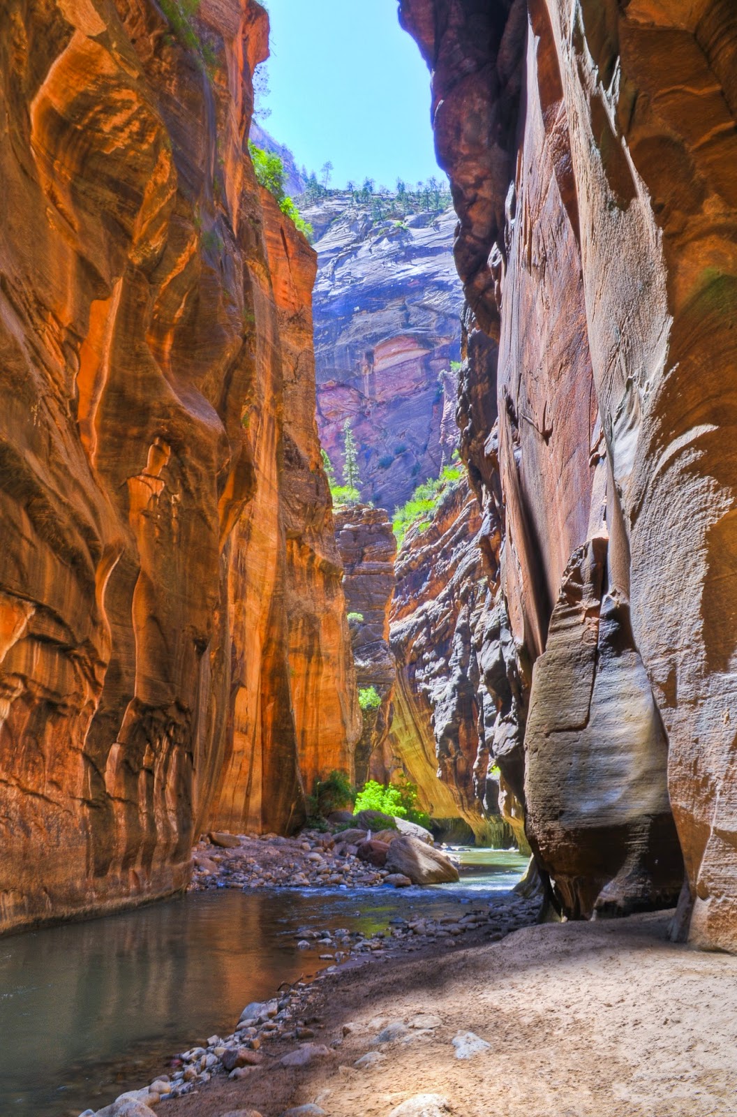
In Zion National Park at the famous Virgin River narrows, water is forced between two narrow but high sandstone walls, an impressive sight. The 2-mile round-trip Riverside Trail leads to the narrows opening. The gorge’s walls can reach 1000 feet high with only 20-30 feet between them.

Top Sights at Bryce Canyon National Park hikers
Among the best ways to enjoy Bryce Canyon National Park’s major sights is via a day hike. Just three short trails will allow you to see each of the park’s highlights – fantastical hoodoos, dark skies, and ancient bristlecone pines.

Best Sights to See at Capitol Reef National Park
Among the best ways to enjoy Capitol Reef National Park’s major sights is via a day hike. Three short trails will allow you to experience each of the park’s highlights – the famous Capitol Dome, fruit picking, and the Golden Throne formation.

Learn more about national park day hiking trails in my Best Sights to See at America’s National Parks series.


Thursday, February 16, 2017

6 Awesome Day Hiking Trails in Utah

Mesa Arch in Canyonlands National Park.
The Windows Trail
Arches National Park
Day hikers can walk across the remnants of dinosaur-era desert on The Windows Trail at Arches National Park near Moab. About 180-140 million years ago during the Jurassic, shifting dunes of fine-grained sand covered what is now Utah and parts of Colorado and Arizona. Over time, as sediment filled over dunes, they hardened into salmon-colored rock known as Entrada Sandstone.

Mesa Arch
Canyonlands National Park
Perhaps one of the most beautiful views of the rugged West is the vista seen through Mesa Arch in Canyonlands National Park. The arch stretches 50 feet atop a 500-foot high cliff overlooking a a valley and buttes of ancient red stones. Day hikers can see the view on the looping 0.5-mile Mesa Arch Trail.

Emerald Pools Trails
Zion National Park
Day hikers can enjoy a natural hanging gardens in the desert on the Emerald Pools Trails in Zion National Park. A combination of paths meander 2.4 miles through a desert oasis in which waterfalls over red sandstone support a lush array of vegetation around three pools.

Hidden Pinyon Trail
Snow Canyon State Park
Day hikers can cross ancient black lava flows and dinosaur-era red Navajo sandstone on the Hidden Pinyon Trail at Snow Canyon State Park in St. George. The route described here combines the Hidden Pinyon Trial and several segments of three others to form a loop that runs roughly 1.5 miles.

Navajo Loop Trail
Bryce Canyon National Park
Where does the superhero and Norse god Thor leaves his hammer when not fighting evil?Some day hikers swear it’s to the northwest of the Navajo Loop Trail in Bryce Canyon National Park. The 1.3-mile trail heads past several hoodoos as it descends from Sunset Point into Bryce Canyon.

Capitol Reef National Park wildflowers
Hear the word “desert,” and you probably don’t think of wildflowers. But some desert locations – such as Capitol Reef National Park – offer a diverse array of wildflowers and other plant life. In fact, 887 plant species have been identified in Capitol Reef. More than 40 of them are rare and endemic. This incredible diversity occurs because of the 7000 feet range in elevation, resulting in a number of microclimates throughout the park. 

Learn more about national park day hiking trails in my Best Sights to See at America’s National Parks series.


Monday, December 26, 2016

5 Fantastic Day Hiking Trails in Utah

Warm sunset light on stairs to North Window Arch in Arches National Park.
Windows Trails
Arches National Park
A set of paths collectively known as the Windows Trails gives day hikers a good sense of what Arches National Park is like without having to drive or traipse all over the desert. You’ll pass a massive hoodoo and three impressive arches all in a matter of a couple of hours of walking.

Mesa Arch Loop Trail
Canyonlands National Park
Perhaps one of the most inspirational – and certainly one of the most beautiful – places to enjoy a sunrise is Canyonlands National Park’s Mesa Arch. Located in the park’s Islands of the Sky section, the arch is easy to reach via the 0.5-mile Mesa Arch Loop Trail. The arch frames a desert landscape from atop a 500-foot vertical cliff.

Weeping Rock Trail
Zion National Park
Day hikers can walk through a natural hanging gardens on the Weeping Rock Trail at Zion National Park. A great family-friendly hike, the footpath ascends a hillside to a concave cut into a rock face from which water seeps. 

Queens Garden and Navajo Loop trails
Bryce Canyon National Park
Visitors to Bryce Canyon National Park can hike through a fantastical maze of totem pole-like rock formations called hoodoos. A combination of the Queens Garden and Navajo Loop trails makes for a 2.2-mile round trip walk in which you get to see the most famous of the hoodoos.

Capitol Gorge Trail
Capitol Reef National Park
Forbidding desert terrain that takes you into the classic Old West awaits hikers of the Capitol Gorge Trail in central Utah’s Capitol Reef National Park. Here you’ll find pioneer inscriptions, a hidden arch, modern petroglyphs, and natural water pools.

Learn more about national park day hiking trails in my Best Sights to See at America’s National Parks series.


Thursday, September 22, 2016

Trail runs to arch nearly a football field long

Landscape Arch spans 290 feet in Arches National Park.
Landscape Arch Trail topo map
Day hikers can see the continent's longest natural arch – Landscape Arch – in east-central Utah.

The Landscape Arch Trail runs 2.5 miles round trip at the far end of Arches National Park. It includes two other smaller, “taster” arches.

To reach the trailhead, drive Arches Scenic Drive (sometimes referred to as "Arches Entrance Road" or "Park Avenue") to its end, where the Devils Garden Trailhead is located. Park there and follow the paved Devils Garden Trail northwest.

The hike begins by cutting between huge red sandstone fins that tower over the trail. Fins can be found all across this section of the park. They form as water fills fractures in the sandstone; when the water freezes in winter, the fractures expand until parts of a single sandstone formation break off, ultimately separating into long, high walls.

While much of the desert sand near the fins is red, you'll notice that clusters of black crust cover great swaths of it. This crust actually is a collection of lifeforms – green algae, lichen, microfungi, mosses, bacteria, but mostly cyanobacteria. This helps slow desert erosion, otherwise much of Arches would be covered in sand dunes. Because of this, always stay on the trail at Arches; if you step on the black crust, the pressure can cause it to break into pieces that rain and wind then scatter, exposing the desert floor.

Nearly a third of a mile in, as the trail swerves north, Tunnel Arch appears atop one of the sandstone fins. You can get a better view of it by taking the spur going to the right once past the sandstone fin. When the spur trail forks, head right to see Tunnel Arch. It is 101 feet long and 45 feet high with a significant amount of sandstone on the bridge; it's growing larger with each year. Continuing straight on the spur takes you to Pine Tree Arch. At 45 x 44 feet wide, it's also fairly stable, so the trail allows hikers to walk right up to it.

Landscape Arch
Returning to the main trail, go left/northwest. The trail passes between more sandstone walls before opening up the desert plain. At that point, you should see glimpses of Landscape Arch, which grows in size as the trail curls toward it.

Landscape Arch is a jaw-dropping sight, a stone ribbon spanning 290 feet, almost a football field in length. A mere 6 feet thick at its skinniest, chunks the size of automobiles have broken off and it still stands.

The trail used to run below the arch, but it was closed after a 60-foot long by 5-foot high slab – weighing 180 tons – fell from the underside of the arch's thinnest section in 1991. A wooden fence marks the trail’s end.

Landscape Arch started as a fin like those passed earlier on the trail. When a recess formed in the fin wall, the power of freezing water and blowing wind slowly carved a hole through the rock and continued to expand it.

World's fifth largest
The arch is the world’s fifth largest. For decades, it was thought to be the longest, but since 2009, four larger ones have been discovered in China.

Though Landscape Arch looks as if it's about to collapse, no one has a good idea when that might occur. Predictions range from at any moment to a few hundred years from now.

You can continue the walk by taking the significantly longer Devils Garden Loop Trail around Landscape Arch to other rock formations on that trail. Among them are Private Arch, Partition Arch, Navajo Arch, Wall Arch, Double O Arch, and the Dark Angel pinnacle. That adds 5 miles to the hike, though. A trail guide is available at the trailhead.

Be forewarned: This trail usually is very busy. Also, during summer, the trail will be very hot with average highs in the 90s; carry plenty of water anytime on this trail but especially in those hot months.

Learn more about national park day hiking trails in my Best Sights to See at America’s National Parks series.


Saturday, April 9, 2016

Hike to vista of Zion Canyon’s south icons

The Watchman from the Watchman Trail in Zion National Park.
Topo map, the Watchman Trail.

Watchman Trail heads up canyon wall in Zion NP


Hikers can see several of Zion National Park’s exotic geological formations on the short Watchman Trail.

The trail runs 2.8-miles round trip through Zion Canyon in the Utah park. Among the sights are The Watchman, the Towers of the Virgin, the Altar of Sacrifice, and the West Temple.

Though located in the desert, the trail can be done year round. During summer, however, avoid the midday heat by hiking it early in the morning or early evening.

Virgin River
To reach the trailhead, from Interstate 15 in St. George take Utah Hwy. 9 (aka as the Zion-Mt. Carmel Highway) to the park’s south/west entrance. Once past the ranger station, take the first road heading right/southeast for the Zion Canyon Visitor Center. After crossing the Virgin River, take the next left and park in the large lot. Take one of the access trails on the lot’s northwest side to the Watchman Trail. Go right/northeast on the trail.

You’re starting at 3963 feet elevation and paralleling the Virgin River. For 15 miles in the park, the Virgin River cuts through cream, pink and red rock representing 150 million years of Earth history, leaving soaring towers, spectacular spires, and imposing monoliths.

Once the trail veers away from the river, it crosses a park road and climbs up the canyon wall beneath Bridge Mountain. The route does get steep. Along the way, you’ll pass junipers, pinion pines, and prickly pear cactus.

Finally, at 456 feet above the canyon floor, the trail reaches the viewpoint. The vista is worth the effort. From here, you can see several of the park’s major geological formations.

Vista sights
To the south is the Watchman, a red mountain that rises 2,200 feet above the viewpoint. It is perhaps the park’s most photographed geological feature.

Directly across the canyon to the east is Mount Kinesava, which tops out at 7285 feet. Hoodoos sit near the mountain’s top, and petroglyphs can be seen on the trail leading to its peak.

To Kinesava’s right/north is The West Temple. The highest exposure of the famous Navajo sandstone – the thick, usually red rock making up Zion's steep cliffs – can be seen on the mountain. This peak reaches 7810 feet elevation.

Right of The West Temple and northwest of the viewpoint is the Towers of the Virgin formation. The Altar of Sacrifice peaks out at 7505 feet in the Towers. A deep stain on the Altars stone looks like blood.

Looking north is The Sentinel, which tops out at 7157 feet. To the northeast is The East Temple, which rises to 7709 feet.

Short loop
To get a slightly closer view of these features, you can take a 0.3-mile loop that leaves from the viewpoint.

The viewpoint is a great spot for a picnic. After enjoying lunch and taking in the sights, retrace your steps back to the lot.

Learn more about national park day hiking trails in my Best Sights to See at America’s National Parks guidebook.


Tuesday, February 9, 2016

Zion N.P. trail heads to hanging gardens

Weeping Rock, Zion National Park. Photo courtesy of Wikipedia.
Topo map, Weeping Rock Trail.

Park's popular
Weeping Rock
Trail runs half
mile round trip


NOTE: This trail was temporarily closed in August 2019 due to a rock fall. 

Day hikers can walk through a natural hanging gardens on the Weeping Rock Trail at Zion National Park.

A great family-friendly hike, the footpath ascends a hillside to a concave cut into a rock face from which water seeps. Though the walk leading to the hanging gardens is somewhat steep, the trail is only a half-mile long.

A popular hike because of the hanging gardens, the great view from it, the short length, and the ease of access, expect the trail to be busy, especially in summer. Still, March through October mark the best time to visit the site, as during winter a flood of water often pours down the rock face and the cold fills the alcove with icicles. Avoid it during rainfalls as well, as the mist that is part of the hanging gardens’ beauty will be absent.

Shaded walk
Reaching the trail during spring through autumn requires taking a park shuttle. Private vehicles generally aren’t allowed April 1-Oct. 30 in Zion Canyon, where the trail is located. A shuttle can be picked up at the Zion Canyon Visitor Center; once on it, get off at the Weeping Rock shuttle stop. If driving, from Utah Hwy. 9 turn north onto Zion Canyon Scenic Drive (also known as Floor of the Valley Drive) and use the Weeping Rock parking lot. The shuttle stop and parking lot are one and the same.

From the parking lot, take the East Mesa Trail south, crossing Echo Canyon Creek via a footbridge. On the bridge’s other side, you’ll immediately reach the junction for the Weeping Rock Trail. Go left/east onto to it.

For about 0.2 miles, the trail rises a hundred feet through shady maples, cottonwoods and ash trees. Cable Mountain rises above the trail to the right/southeast.

The trail recrosses the creek via a footbridge. From here, the path is uphill all the way as the canyon walls close about you.

Weeping Rock
The out-and-back trail ends at the Weeping Rock. Water seeps from the wall because the Kayenta layer of rock beneath it prevents moisture from seeping further downward. The only place the water can go is out the layer of sandstone here.

The result is a lush garden fed by the spring water, which has been in the rock for about 1200 years. Mosses, ferns and columbines all can thrive on the moist vertical walls.

When standing next to the alcove, you’ll definitely feel the mist form the sprinkles. You’ll also notice that the moisture keeps the area a few degrees cooler than the rest of the trail.

On the way back to the parking lot, you’ll be treated to a great view of The Organ and Angels Landing rock formations. The former rises over the Virgin River’s Big Bend west of the Weeping Rock.

Be sure to watch your step on this trail, as the rock surfaces can be slippery. Though the trail is paved, it’s too steep for wheelchairs or strollers.

Learn more about national park day hiking trails in my Best Sights to See at America’s National Parks guidebook.


Wednesday, September 2, 2015

Video of Capitol Reef N.P. wildflowers

Nearly 900 plant species thrive at Capitol Reef National Park.
Hear the word “desert,” and you probably don’t think of wildflowers. But some desert locations – such as Capitol Reef National Park in Utah – offer a diverse array of wildflowers and other plant life.

In fact, 887 plant species have been identified in Capitol Reef. More than 40 of them are rare and endemic. This incredible diversity occurs because of the 7000 feet range in elevation, resulting in a number of microclimates throughout the park.

The showy flower blossoms and their verdant green leaves often provide a wonderful accent against the surrounding desert’s earth tones:


The best time to enjoy wildflowers at Capitol Reef is mid-April through July. Among the flowers you can see then include Indian Paintbrush and Utah Penstemon (blossoms April-June), Yellow Catspaw and Silvery Townsendia (April-July), Naked Stem Sunrays (mid-April-July), Showy Four O’clock (May-June), and Mountain Pepperplant (May-September).

Related article:
Best trails for seeing Capitol Reef’s wonders

Learn more about national park day hiking trails in my Best Sights to See at America’s National Parks guidebook.


Saturday, August 29, 2015

Video of Canyonland's Mesa Arch at sunrise

Perhaps one of the most inspirational – and certainly one of the most beautiful – places to enjoy a sunrise is Canyonlands National Park’s Mesa Arch.

Located in the park’s Islands of the Sky section, the arch is easy to reach via the 0.5-mile Mesa Arch Loop Trail. The arch frames a desert landscape from atop a 500-foot vertical cliff. Here’s a pan of that view at sunrise:


The Colorado River carved out Buck Canyon, the desert framed by the arch. The bordering La Sal Mountains often sport snow-covered peaks.

The Mesa Arch isn’t just unique for its views but also for the way it formed. A pothole arch, water pooling on the surface behind the sandstone gradually eroded the window at the mesa’s edge.

Also see:
Best day hikes for seeing Canyonland’s wonders

Learn more about national park day hiking trails in my Best Sights to See at America’s National Parks guidebook.


Tuesday, August 25, 2015

Video of Thor’s Hammer at Bryce Canyon

Thor's Hammer on Navajo Loop Trail.
Where does the superhero and Norse god Thor leaves his hammer when not fighting evil?

Some day hikers swear it’s to the northwest of the Navajo Loop Trail in Bryce Canyon National Park.

Topo map for Navajo Loop Trail. Map courtesy of NPS.

The 1.3-mile trail heads past several hoodoos as it descends from Sunset Point into Bryce Canyon. It often is done in conjunction with the Queens Garden Trail.

The totem pole-like hoodoos form at Bryce Canyon thanks to frost wedging –water first seeps into fissures of the sandstone rock, then when freezing expands, causing erosion. Bryce Canyon experiences about 200 freeze/thaw cycles annually.

Among the hoodoos visible on the Navajo Loop Trail is the aptly named Thor’s Hammer and the set of hoodoos known as the Amphitheater to the hammer’s east:


Though a short trail, the steep descent into the canyon means a steep walk back up – about 550 feet, in fact – and it’s at a high altitude at that. Be aware that rock slides also sometimes close sections of the trail.

Also see:
Hike fantasyland in Utah's Bryce Canyon National Park
Best day trails for seeing Bryce Canyon's wonders

Learn about other great national park day hiking trails in my Best Sights to See at America’s National Parks guidebook.


Monday, August 17, 2015

Video of Arches N.P.’s The Windows

Day hikers can walk across the remnants of dinosaur-era desert on The Windows Trail at Arches National Park near Moab, Utah.

About 180-140 million years ago during the Jurassic, shifting dunes of fine-grained sand covered what is now Utah and parts of Colorado and Arizona. Over time, as sediment filled over dunes, they hardened into salmon-colored rock known as Entrada Sandstone.

Fast forward to the modern day. Rain, wind and freezing has eroded away much of the rock covering the Jurassic-era sandstone and shaped it into interesting geological features. One common sight in the national park is an arch, such as The Windows:


More than 2,000 cataloged arches have been found in the park’s nearly 120 square miles. The Windows are among the easiest to reach by day hiking the 1-mile round-trip Windows Trail.

Also see:
Children will love day hike on Windows Trails in Arches National Park
Best trails for seeing Arches National Park’s numerous wonders

Learn about other great national park day hiking trails in my Best Sights to See at America’s National Parks guidebook.


Thursday, August 13, 2015

Video of Zion N.P.’s Emerald Pools


Day hikers can enjoy a natural hanging gardens in the desert on the Emerald Pools Trails in Zion National Park.

A combination of paths meander 2.4 miles through a desert oasis in which waterfalls over red sandstone support a lush array of vegetation around three pools. Among the plants are ferns, mosses and a variety of flowers, but even fragrant juniper, oak, pinyon, cottonwood and boxelder trees can be spotted in alcoves and notches.

Here’s a video of the Emerald Pools:


Also see:
Article more fully describing the trail

Learn more about national park day hiking trails in my Best Sights to See at America’s National Parks guidebook.


Monday, June 22, 2015

Video of Hickman Bridge Trail formations

Day hikers can see fantastic rock formations on the Hickman Bridge Trail at Capitol Reef National Park in Utah.

Sitting amid the geological wonder of the Waterpocket Fold, the white domes and cliffs look like the U.S. Capitol building. At 2-miles round trip, the trail offers great views of the dome as well as other intriguing rock formations near the Fremont River.

To reach the trail, from the visitor center for the park’s Fruita historic area, take Utah Route 24 east. A parking lot is on the road’s left/north side two miles from the visitor center.

Here’s a video of Capitol Dome and surrounding rock formations near the trailhead:


There are several other trails at the national park that also are worth exploring.

Learn about other great national park day hiking trails in my Best Sights to See at America’s National Parks guidebook.


Wednesday, June 10, 2015

Video of Canyonland NP’s Mesa Arch

Perhaps one of the most beautiful views of the rugged West is the vista seen through Mesa Arch in Canyonlands National Park.

The arch stretches 50 feet atop a 500-foot high cliff overlooking a a valley and buttes of ancient red stones. Day hikers can see the view on the looping 0.5-mile Mesa Arch Trail.

To reach the trailhead, from the park’s Sky Visitor Center, drive 6.3 miles south. The parking lot is on the west/left side. Mesa Arch sits at the trail’s midpoint.

Here’s a video of the view through Mesa Arch:


Several other great trails offer intersting sights at Canyonlands National Park.

Learn more about national park day hiking trails in my Best Sights to See at America’s National Parks guidebook.


Saturday, June 6, 2015

Video of Bryce Canyon hoodoos

Day hikers can see fantastical rock spires on the Navajo Loop and Queens Garden trails at Bryce Canyon National Park in Utah.

Hoodoos are unusual landforms in which a hard caprock slows the erosion of the softer mineral beneath it. The result is a variety of fantastical shapes. Children will delight in the chimerical scenery encircling Bryce Canyon’s Queens Garden.

To reach the national park, taking State Route 63 into Bryce Canyon. Park at the nature center and general store north of the Lodge. The trailhead is southeast of the nature center heading toward Sunrise Point.

Here’s a brief video of the Queens Garden hoodoos:


Here's an article more fully describing the trail.

Learn about other great national park day hiking trails in my Best Sights to See at America’s National Parks guidebook.


Tuesday, June 2, 2015

Arches National Park's Balanced Rock video

Day hikers can take a short walk to an astounding 55-foot tall block on the Balanced Rock Trail at Arches National Park in eastern Utah.

To reach the national park, from Interstate 70 take U.S. Hwy. 191 south. The park’s entrance is on the road’s left/east side. From the visitor center, drive up the cliff along Park Avenue. At 9.2 miles, you’ll come to the parking lot for Balanced Rock and the Windows arches.

The trail leads to a dinosaur-era rock that looks like a ball atop a pedestal. The sandstone spire technically is known as a hoodoo.

Here’s a video of Balanced Rock taken along the trail:


After taking in the geological wonder on the quarter-mile loop, visitors can continue via The Windows Trail to see The Windows arches. Here's an article more fully describing the trail.

Learn about other great national park day hiking trails in my Best Sights to See at America’s National Parks guidebook.


Wednesday, March 18, 2015

Video of Zion National Park’s The Narrows

In Zion National Park at the famous Virgin River narrows, water is forced between two narrow but high sandstone walls, an impressive sight. The 2-mile round-trip Riverside Trail leads to the narrows opening.

The Narrows are located in Zion Canyon. The gorge’s walls can reach 1000 feet high with only 20-30 feet between them.

Here’s a brief video showing The Narrows:


Hike the trail in late summer when the water is warmer and lower than earlier in the year, so that you can wade into the narrows. When water levels are too high or flash floods occur, the park services closes the trail.

Learn more about national park day hiking trails in my Best Sights to See at America’s National Parks guidebook.


Sunday, August 3, 2014

Best trails for enjoying Zion NP’s wonders

Riverside Trail through Zion Narrows
Among the best ways to see Zion National Park’s top sights is via a day hike. Just five trails will allow you to enjoy each of the park’s highlights – a canyon’s exotic geological features, the world’s second longest arch, an incredible river narrows, hanging gardens, and magnificent California condors.

Zion Canyon
For 15 miles, the Virgin River cuts through cream, pink and red rock representing 150 million years of Earth history. The result is soaring towers, spectacular spires, and imposing monoliths. The 2-mile round trip Watchman Trail allows hikers to see several of the canyon’s exotic geological formations, including the Beehives, the Towers of the Virgin, the West Temple, the Altar of Sacrifice and the Watchman.

Kolob Arch
The park boasts the world’s second longest natural arch, Kolob Arch, which spans 287.4 feet. It can be seen in a long day hike through the backcountry on the 14-mile round trip Kolob Arch Trail, which leaves from the Lee Pass parking area.

Zion Narrows
At the famous river narrows, water is forced through a narrows between two high sandstone walls, an impressive sight. The 2-mile round-trip Riverside Trail leads to the narrows opening. Hike the trail in late summer when the water is warmer and lower than earlier in the year so that you can wade into the narrows.

Hanging gardens
At Weeping Rock, water seeps out of a concave cut in a sandstone wall, allowing for a lush hanging gardens to flourish amid the desert. The 1-mile round-trip Weeping Rock Trail is uphill with a steep stairs leading to the hanging gardens, but the site’s beauty is worth the climb.

California condors
More than 200 bird species can be found in the park, and the most magnificent of them is the rare California condor. They usually can be seen flying over the 5-mile round-trip Angels Landing Trail; the trail does have steep drop-offs so is not for young children.

Learn more about national park day hiking trails in my Best Sights to See at America’s National Parks guidebook.


Sunday, May 4, 2014

Cool rock formations, opportunity to pick fruit await Capitol Reef National Park hikers

Children enjoy peaches picked from historic orchards at Capital Reef
National Park. Photo courtesy Capital Reef NPS.
Among the best ways to enjoy Capitol Reef National Park’s major sights is via a day hike. Three short trails will allow you to experience each of the park’s highlights – the famous Capitol Dome, fruit picking, and the Golden Throne formation.

Capitol Dome
Sitting amid the geological wonder of the Waterpocket Fold, the white domes and cliffs look like the U.S. Capitol building. At 2-miles round trip, the Hickman Bridge Trail offers great views of the dome as well as other intriguing rock formations near the Fremont River.

Fruit picking
The Park Service maintains more than 3,100 trees – including cherry, apricot, peach, pear and apple – in orchards planted decades ago by Mormon pioneers. For a small fee, park visitors can pick the fruit when in season. While there’s no designated trail, the Historic Fruita Orchards Walk takes you through the fruit trees located alongside Sulphur Creek east of the Utah Hwy. 24 and Camp Ground Road/Scenic Drive junction.

The Golden Throne
A carbonate dome has stained the rock below it yellow, making this large rock formation stand out in a terrain known for its white sandstone summits. The 4-mile round trip Golden Throne Trail climbs 730 feet from a gorge bottom to a cliff top offering an impressive view of the Golden Throne.

Learn about other great national park day hiking trails in my Best Sights to See at America’s National Parks guidebook.


Sunday, April 27, 2014

See pinnacles, petroglyphs, panoramic vistas on Canyonlands National Park trails

Grand View Point Trail. Photo courtesy of Canyonlands NPS.
Among the best ways to see Canyonlands National Park’s major sights is via a day hike. Just three short trails will allow you to enjoy the park’s highlights – cool rock formations, millennia-old petroglyphs, and incredible vistas.

Needles rock formations
Some 300 million years of rock layers form the red- and white-banded pinnacles known in Canyonlands at needles. The 0.6-mile round trip Pothole Point Trail offers great views of the needles as well a couple of other major geological wonders – slickrock and potholes.

Newspaper Rock
An amazing number of petroglyphs stretching back 2000 years can be found on the rock; some were made by the hand of the mysterious Anasazi. More of a car wayside than a day hike, the undesignated Newspaper Rock Trail runs all of 40 yards between the parking lot off of Utah Hwy. 211 (mile marker 6.7) and the ancient artwork.

Island in the Sky overlook
Canyonlands is named for the virtually impenetrable maze of gorges and mesas across this section of Utah. The 2-mile round trip Grand View Point Trail runs atop the Island in the Sky mesa, offering panoramic views of the wild terrain a thousand feet below sheer cliffs.

Learn more about national park day hiking trails in my Best Sights to See at America’s National Parks guidebook.


Saturday, April 26, 2014

Exotic hoodoos, starry skies, ancient trees await Bryce Canyon National Park hikers

Balanced-rock hoodoos on the Under-the-Rim Trail.
Among the best ways to enjoy Bryce Canyon National Park’s major sights is via a day hike. Just three short trails will allow you to see each of the park’s highlights – fantastical hoodoos, dark skies, and ancient bristlecone pines.

Hoodoos
Tens of millions of years in the making, some of these pinnacles reach up to 200 feet high in a series of amphitheaters strung across the park. The 4-mile round trip Under-the-Rim Trail sends hikers into a stone forest featuring several balanced-rock hoodoos.

Dark skies
Boasting among the darkest skies in continental America, Bryce Canyon visitors can see up to 7,500 stars with the naked eye – nearly four times more than is typical in a rural area. The Piracy Point Trail, a half-mile round trip from Far View Point, leads to a primitive picnic area overlooking a cliff that is perfect for stargazing.

Bristlecone pines
The rare bristlecone pine can live for hundreds of years and often resides at stark, high elevations. At 2-miles round trip, The Bristlecone Loop heads past 1,800-year-old trees and to magnificent vistas at an elevation of 9,100-plus feet.

Learn about other great national park day hiking trails in my Best Sights to See at America’s National Parks guidebook.