To reach the trail, from the park’s visitor center take the Scenic Drive for 10 miles. When the paved section turns to dirt and splits, head left for about three miles. You’ll want a four-wheel drive vehicle or one with high clearance, as the road is rough albeit scenic. At its end is a gravel parking area. The trailhead starts near a covered picnic shelter in the parking lot.
The 2-mile roundtrip trail consists of fairly smooth sand, though it can be rocky at spots. It’s fairly wide, often no less than 10 feet at its narrowest as it follows the gorge:

Map of Capital Reef National Park (courtesy USGS):

Map of Capital Gorge Trail (courtesy Capital Reef NPS):

Relief map of Capital Gorge Trail (courtesy Capital Reef NPS):

Elevation chart for Capital Gorge Trail (courtesy Capital Reef NPS):

About a quarter mile in, look for the sign pointing to the petroglyphs. Fremont Indians etched these hands, spirals and ghostly effigies nearly a thousand years ago (courtesy Wikipedia):

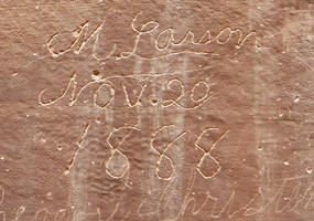
About a half mile into the trail is the Pioneer Register. Hundreds of names and dates were carved into the rocks by pioneers traveling through the gorge during the late 1800s up to the 1920s:
Evening light on the trail:

At one time, the gorge was a road that led to and from the town of Notom; here cars in 1939 traverse the gorge:

Learn more about national park day hiking trails in my Best Sights to See at America’s National Parks guidebook.
