Showing posts with label Capitol Reef National Park. Show all posts

Wednesday, September 2, 2015

Video of Capitol Reef N.P. wildflowers

Nearly 900 plant species thrive at Capitol Reef National Park.
Hear the word “desert,” and you probably don’t think of wildflowers. But some desert locations – such as Capitol Reef National Park in Utah – offer a diverse array of wildflowers and other plant life.

In fact, 887 plant species have been identified in Capitol Reef. More than 40 of them are rare and endemic. This incredible diversity occurs because of the 7000 feet range in elevation, resulting in a number of microclimates throughout the park.

The showy flower blossoms and their verdant green leaves often provide a wonderful accent against the surrounding desert’s earth tones:


The best time to enjoy wildflowers at Capitol Reef is mid-April through July. Among the flowers you can see then include Indian Paintbrush and Utah Penstemon (blossoms April-June), Yellow Catspaw and Silvery Townsendia (April-July), Naked Stem Sunrays (mid-April-July), Showy Four O’clock (May-June), and Mountain Pepperplant (May-September).

Related article:
Best trails for seeing Capitol Reef’s wonders

Learn more about national park day hiking trails in my Best Sights to See at America’s National Parks guidebook.


Monday, June 22, 2015

Video of Hickman Bridge Trail formations

Day hikers can see fantastic rock formations on the Hickman Bridge Trail at Capitol Reef National Park in Utah.

Sitting amid the geological wonder of the Waterpocket Fold, the white domes and cliffs look like the U.S. Capitol building. At 2-miles round trip, the trail offers great views of the dome as well as other intriguing rock formations near the Fremont River.

To reach the trail, from the visitor center for the park’s Fruita historic area, take Utah Route 24 east. A parking lot is on the road’s left/north side two miles from the visitor center.

Here’s a video of Capitol Dome and surrounding rock formations near the trailhead:


There are several other trails at the national park that also are worth exploring.

Learn about other great national park day hiking trails in my Best Sights to See at America’s National Parks guidebook.


Sunday, May 4, 2014

Cool rock formations, opportunity to pick fruit await Capitol Reef National Park hikers

Children enjoy peaches picked from historic orchards at Capital Reef
National Park. Photo courtesy Capital Reef NPS.
Among the best ways to enjoy Capitol Reef National Park’s major sights is via a day hike. Three short trails will allow you to experience each of the park’s highlights – the famous Capitol Dome, fruit picking, and the Golden Throne formation.

Capitol Dome
Sitting amid the geological wonder of the Waterpocket Fold, the white domes and cliffs look like the U.S. Capitol building. At 2-miles round trip, the Hickman Bridge Trail offers great views of the dome as well as other intriguing rock formations near the Fremont River.

Fruit picking
The Park Service maintains more than 3,100 trees – including cherry, apricot, peach, pear and apple – in orchards planted decades ago by Mormon pioneers. For a small fee, park visitors can pick the fruit when in season. While there’s no designated trail, the Historic Fruita Orchards Walk takes you through the fruit trees located alongside Sulphur Creek east of the Utah Hwy. 24 and Camp Ground Road/Scenic Drive junction.

The Golden Throne
A carbonate dome has stained the rock below it yellow, making this large rock formation stand out in a terrain known for its white sandstone summits. The 4-mile round trip Golden Throne Trail climbs 730 feet from a gorge bottom to a cliff top offering an impressive view of the Golden Throne.

Learn about other great national park day hiking trails in my Best Sights to See at America’s National Parks guidebook.


Friday, July 12, 2013

Photo, map album of Capitol Gorge Trail

Forbidding desert terrain that takes you into the classic Old West awaits hikers of the Capitol Gorge Trail in central Utah’s Capitol Reef National Park. Here you’ll find pioneer inscriptions, a hidden arch, modern petroglyphs, and natural water pools.

To reach the trail, from the park’s visitor center take the Scenic Drive for 10 miles. When the paved section turns to dirt and splits, head left for about three miles. You’ll want a four-wheel drive vehicle or one with high clearance, as the road is rough albeit scenic. At its end is a gravel parking area. The trailhead starts near a covered picnic shelter in the parking lot.

The 2-mile roundtrip trail consists of fairly smooth sand, though it can be rocky at spots. It’s fairly wide, often no less than 10 feet at its narrowest as it follows the gorge:


Map of Capital Reef National Park (courtesy USGS):


Map of Capital Gorge Trail (courtesy Capital Reef NPS):


Relief map of Capital Gorge Trail (courtesy Capital Reef NPS):


Elevation chart for Capital Gorge Trail (courtesy Capital Reef NPS):


About a quarter mile in, look for the sign pointing to the petroglyphs. Fremont Indians etched these hands, spirals and ghostly effigies nearly a thousand years ago (courtesy Wikipedia):


About a half mile into the trail is the Pioneer Register. Hundreds of names and dates were carved into the rocks by pioneers traveling through the gorge during the late 1800s up to the 1920s:


Evening light on the trail:


At one time, the gorge was a road that led to and from the town of Notom; here cars in 1939 traverse the gorge:


Learn more about national park day hiking trails in my Best Sights to See at America’s National Parks guidebook.


Tuesday, December 20, 2011

Great kids' trail: Capitol Reef's Capitol Gorge

Whiptail lizard at Capitol Reef National Park.
Photo courtesy Capitol Reef NPS.

Hidden arch, natural water pools await hikers


Forbidding desert terrain that takes you into the classic Old West awaits hikers of the Capitol Gorge Trail in central Utah's Capitol Reef National Park. Here you'll find pioneer inscriptions, a hidden arch, modern petroglyphs, and natural water pools.

Either spring or fall are great times to visit. Always watch weather reports, though, to ensure no storms are nearby so you don't get caught in a flashflood. You'll also want to bring sunscreen, probably a brimmed hat, and definitely enough water for all.

To reach the trail, from the park's visitor center take the Scenic Drive for 10 miles. When the paved section turns to dirt and splits, head left for about three miles. You'll want a four-wheel drive vehicle or one with high clearance, as the road is rough albeit scenic. At its end is a gravel parking area.

Millennia-old petroglyphs
The trailhead starts near a covered picnic shelter in the parking lot. The 2-mile roundtrip trail consists of fairly smooth sand, though it can be rocky at spots. It's fairly wide, often no less than 10 feet at its narrowest as it follows the gorge.

About a quarter mile in, look for the sign pointing to the petroglyphs. Fremont Indians etched these hands, spirals and ghostly effigies nearly a thousand years ago.

The trail then joins a streambed (hence the need to watch for storms to avoid flashfloods). Sheer cliffs of yellow, gray and dull brown Navajo sandstone, streaked by desert varnish, rise on both sides.

You'll almost certainly see whiptail and collared lizards on the trail. If lucky, you may spot grazing bighorn sheep. Despite being a desert, more than 300 species call the park home, including chipmunks, squirrels, golden eagles, ravens, deer, antelope, ringtail raccoons and bats. Mountain lions and coyote also are present but rarely seen by day hikers. Among the common flora are red rimrock paintbrush; yellow Mormon tea, woolly milkvetch, puccoon, and roundleaf buffaloberry.
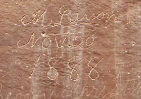
Wall of names
About a half mile into the trail is the Pioneer Register. Kids will delight in reading the hundreds of names and dates carved into the rocks by pioneers traveling through the gorge during the late 1800s up to the 1920s. Don't add your own name to the rocks, however. Doing so ruins a historical site and is illegal, carrying a $250 fine.

The sheer cliffs recede as heading farther up the gorge. One spur worth taking up a tributary ravine is to the Tanks, a series of small pools and potholes that often contain water. A series of switchbacks marked by cairns leads to the Tanks, though you'll need to watch closely for them. Visible on the descent back to the gorge is a small arch in the drainage.

The Tanks at a mile into the gorge marks a good spot to turn back. For more ambitious hikers, the streambed can be followed toward Notom - the gorge once was a main road to what once a small village - but be wary of flashfloods. Should you follow the streambed, the gorge opens at the reef's edge as the Navajo sandstone gives way to the Carmel Formation.

Learn about other great national park day hiking trails in my Best Sights to See at America’s National Parks guidebook.