Showing posts with label Pioneer (Yellow) Trail. Show all posts

Wednesday, September 17, 2014

Hill trail leads to one of WI's top waterfalls

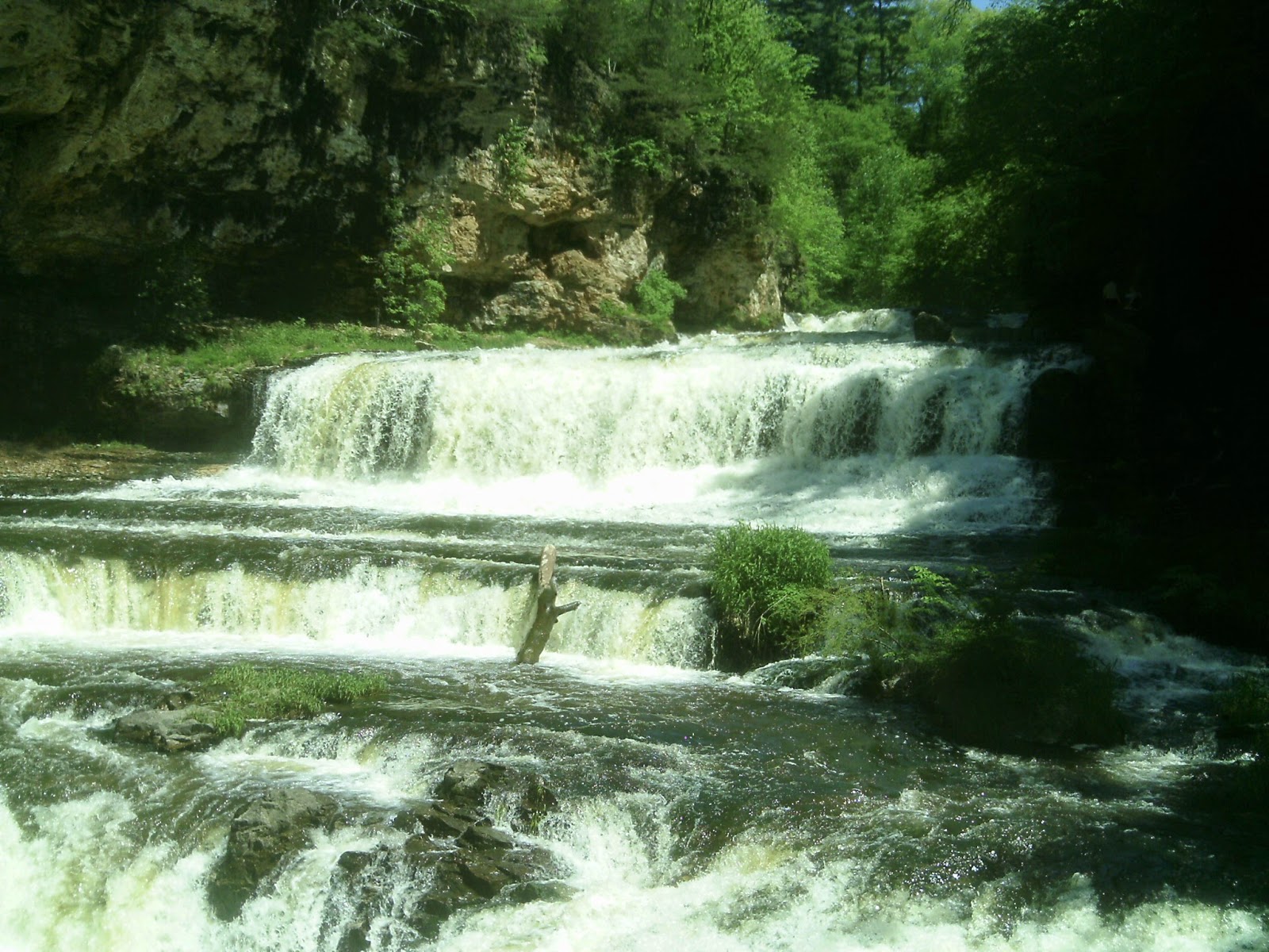
Willow Falls from the Willow Falls Hill (Gray) Trail.
Willow Falls Hill (Gray) Trail

Willow Falls Hill
(Gray) Trail runs
0.85-miles total


A waterfall that many say is among Wisconsin’s best awaits day hikers on the Willow Falls Hill (Gray) Trail.

The trail runs about 0.85-miles round trip on Willow Falls State Park’s eastern side. Late spring and June mark a great time to hike the trail, as the falls will be in full flow, especially within a day or two of a rainfall.

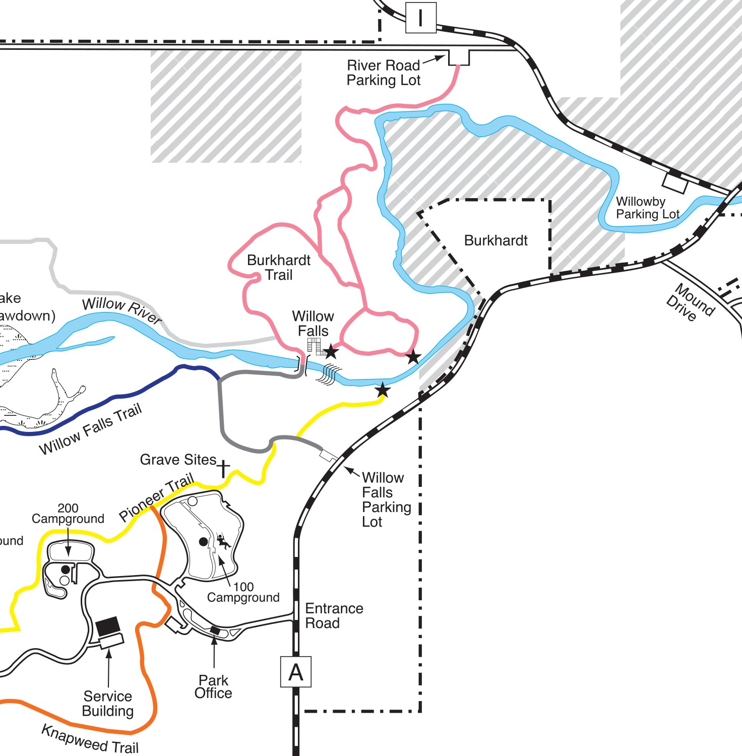
To reach the trail, take Exit 4 from Interstate 94, heading north on U.S. Hwy. 12 for about 1.6 miles. Follow County Road U for 0.3 miles to County Road A. Drive north, continuing past the main park entrance for about 0.4 miles. Park in the Willow Falls Parking Lot on the road’s left/west side. The trailhead leaves from the lot’s northwest corner.

Field and woods
For the first 300 feet or so, the trail crosses an open field. Swaths of this region were prairie before settlers arrived, and park officials are allowing this section to return to that natural condition.

In the field, the first trail intersection heads north to an overlook of Willow Falls. Though a scenic view, instead continue straight/west to the falls’ base.

The trail enters a wooded area, where it reaches a second intersection, for the Pioneer (Yellow) Trail, which heads to the 100 Campground. Watch the trail markers to make sure you stay on the Willow Falls Hill (Gray) Trail.

Following the intersection, the trail descends a steep hill, taking you into the river valley. Early in the morning and at dusk, you stand a good chance of spotting whitetail deer, eagles, squirrels and chipmunks.

At the hill’s bottom, the trail veers north and intersects the Willow Falls (Blue) Trail. Again, watch for the gray trail markers and head north and then east.

By this point, you’ll hear the roar of the falls and will come alongside the Willow River, as it flows toward the St. Croix River.

In a little more than a hundred feet, the trail arrives at a wooden footbridge that crosses the Willow, and the falls comes into full view.

200-foot high walls
The Willow River ultimately descends 45 feet over the falls. The main drop is about 15 feet high but more than a hundred feet wide.

A sandstone gorge nestles the falls beneath 200-foot high walls. Geologists estimate the rock at the bottom of the gorge is about 600 million years old and have found trilobite fossils in it.

While the best vistas of the falls and gorge are on the bridge, also cross to its north side, where you can walk down onto the rocks alongside the gorge walls and get a bit closer to the falls. Be careful of slick rocks and small pools that can make the walk slippery and even get your shoes and socks wet.

The trail heading north from the bridge is the Burkhardt (Pink) Trail. It heads through a wooded river valley.

After taking in your fill of the falls and gorge, retrace your steps back to the parking lot. Though the trail’s short length is seemingly ideal for young children, a steep hill to climb back up after the excitement of seeing the falls will be anticlimactic (pun intended), so before taking this route, make sure kids are physically fit or that you’re willing to carry them. A bench along the way does allow for a convenient rest break.

Learn more about nearby day hiking trails in my Day Hiking Trails of St. Croix County.


Sunday, January 12, 2014

Diverse array of trails await at Willow River

Willow Falls, Willow Rivers State Park
Photo courtesy Wisconsin DNR.
Day hikers will find several excellent trails – including several to a scenic waterfall – at Willow River State Park outside of Hudson, Wis.

To reach Willow River State Park, take Exit 4 from Interstate 94, and head north on U.S. Hwy. 12 for about 1.6 miles. Go County Road U for about 0.3 miles to County Road A, where you’ll continue for another 1.5 miles. The park’s entrance is on the road’s left side. Some trails listed here are best reached from other park entry points, however.

The state park’s trails include:
g Burkhardt (Pink) Trail A walk alongside a scenic river, Willow Falls, and some impressive overlooks await hikers on this trail, which actually is three miles of connecting paths. It’s also known as the Pink Path because of its color on state park maps.
g Hidden Ponds Nature (Black) Trail The half-mile interpretive loop is paved, level and out of the wind, ideal for young children. The walking path is right next to the park’s nature center and a short stroll to the park’s swimming beach.
g Knapweed (Orange) Trail The trail runs for 0.9 miles one-way alongside an effort to restore prairie as it existed in Wisconsin before pioneers arrived during the 1800s. Among the plants you may notice – especially in late June to early July when it blossoms – is the purple knapweed, the trail’s namesake but unfortunately an invasive species that actually threatens the prairie and other ecosystems.
g Little Falls (Green) Trail – The 0.7-mile paved trail rambles alongside a Little Falls Lake between Little Falls Dam and the campground. A variety of waterfowl can be spotted from it.
g Mound (White) Trail – Located in an often overlooked section of the state park, the 1.1-mile Mound Trail offers views of the Willow River and a glacial mound (a hill that resisted erosion during the last Ice Age) on the opposite shore.
g Nelson Farm (Silver) Trail The state park’s newest trail opened in summer 2012. The 3.7-mile trail heads from a bridge on the Trout Brook (Purple) Trail through several ecosystems to the lake’s north side.
g Oak Ridge (Brown) Trail – Hikers can learn about geological features created during the last ice age on this 1.1-mile trail. It heads from the beach through hardwood forests.
g Pioneer (Yellow) Trail – Among the best views of Willow Falls can be seen from an overlook on the 1.2-mile trail. It also passes the gravesites of the area’s first white settlers.
g Trout Brook (Purple) Trail This 1.4-mile loop takes hikers through red pine stands and open prairie. You’ll be able to spot great blue heron, ducks and snapping turtles along the way.
g Whitetail (Red) Trail – Expect to spot at least the tracks of whitetail if not the graceful deer itself on this 0.7-mile trail. The path cuts across open fields and along a forest’s edge.
g Willow Falls Hill (Gray) Trail – The quickest way to reach beautiful Willow Falls is this 0.4 trail. The downside is the hill is quite steep, which may not be ideal for very young children.
g Willow Falls (Blue) Trail – An easier but longer trail for reaching the waterfalls is this 1-mile route. It follows the Little Falls Lake and Willow River shoreline to the falls.

Read more about day hiking the scenic riverway in my guidebook Hittin’ the Trail: Day Hiking the St. Croix National Scenic Riverway.