 |
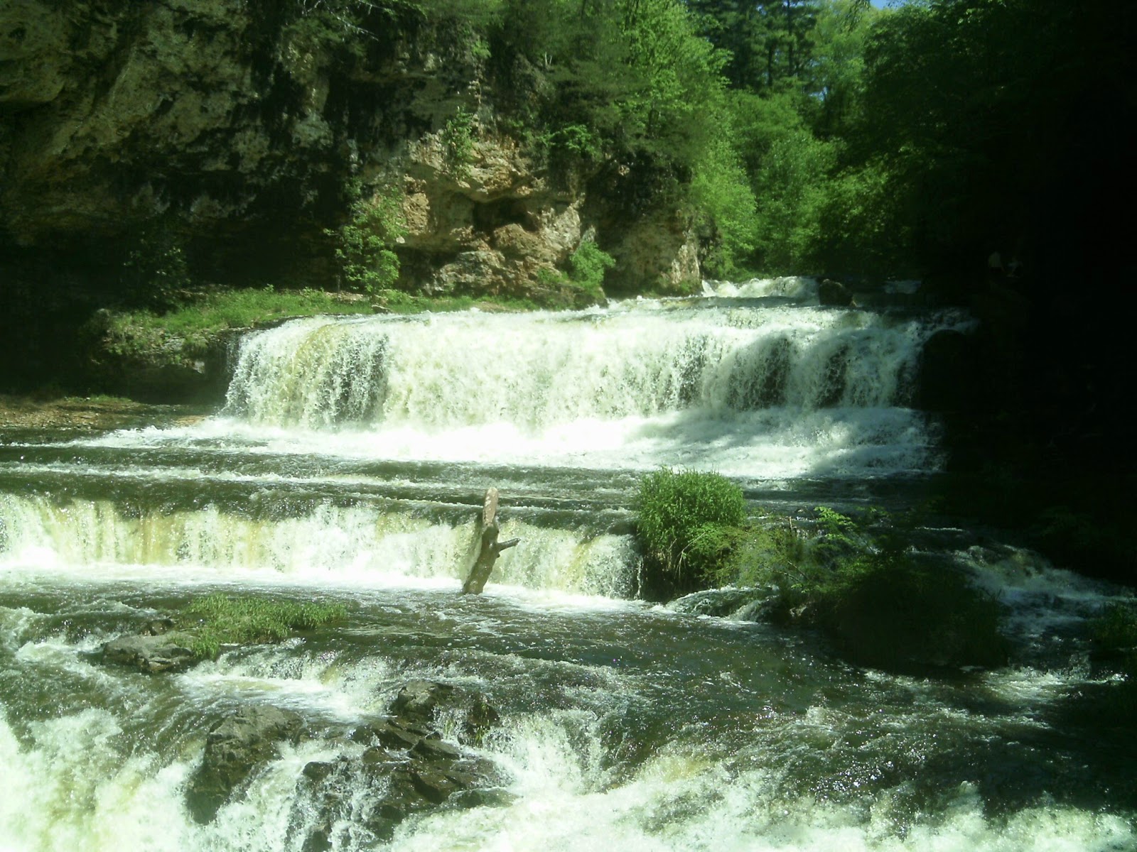
| Willow Falls from the Willow Falls Hill (Gray) Trail. |
 |
| Willow Falls Hill (Gray) Trail |
Willow Falls Hill
(Gray) Trail runs
0.85-miles total
A waterfall that many say is among Wisconsin’s best awaits day hikers on the Willow Falls Hill (Gray) Trail.
The trail runs about 0.85-miles round trip on Willow Falls State Park’s eastern side. Late spring and June mark a great time to hike the trail, as the falls will be in full flow, especially within a day or two of a rainfall.
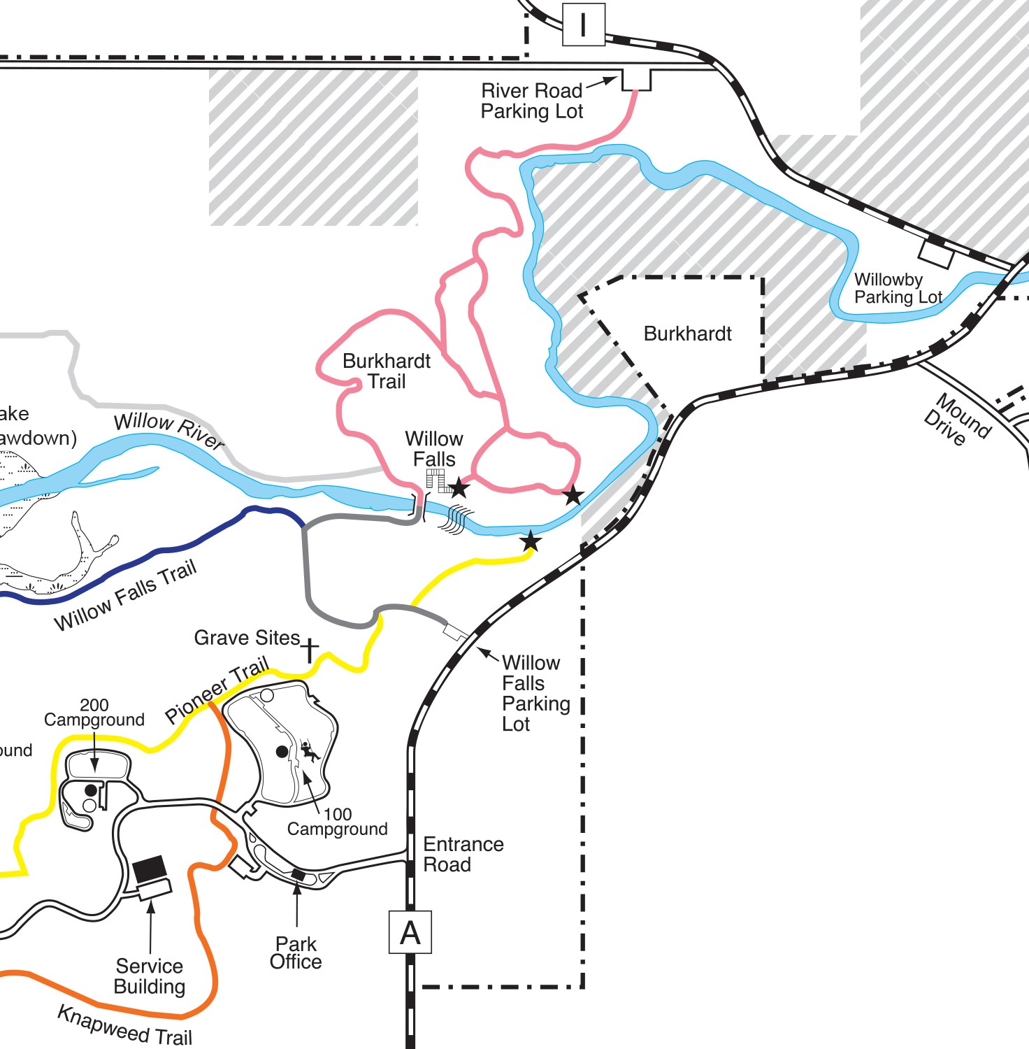
To reach the trail, take Exit 4 from Interstate 94, heading north on U.S. Hwy. 12 for about 1.6 miles. Follow County Road U for 0.3 miles to County Road A. Drive north, continuing past the main park entrance for about 0.4 miles. Park in the Willow Falls Parking Lot on the road’s left/west side. The trailhead leaves from the lot’s northwest corner.
Field and woods
For the first 300 feet or so, the trail crosses an open field. Swaths of this region were prairie before settlers arrived, and park officials are allowing this section to return to that natural condition.
In the field, the first trail intersection heads north to an overlook of Willow Falls. Though a scenic view, instead continue straight/west to the falls’ base.
The trail enters a wooded area, where it reaches a second intersection, for the Pioneer (Yellow) Trail, which heads to the 100 Campground. Watch the trail markers to make sure you stay on the Willow Falls Hill (Gray) Trail.
Following the intersection, the trail descends a steep hill, taking you into the river valley. Early in the morning and at dusk, you stand a good chance of spotting whitetail deer, eagles, squirrels and chipmunks.
At the hill’s bottom, the trail veers north and intersects the Willow Falls (Blue) Trail. Again, watch for the gray trail markers and head north and then east.
By this point, you’ll hear the roar of the falls and will come alongside the Willow River, as it flows toward the St. Croix River.
In a little more than a hundred feet, the trail arrives at a wooden footbridge that crosses the Willow, and the falls comes into full view.
200-foot high walls
The Willow River ultimately descends 45 feet over the falls. The main drop is about 15 feet high but more than a hundred feet wide.
A sandstone gorge nestles the falls beneath 200-foot high walls. Geologists estimate the rock at the bottom of the gorge is about 600 million years old and have found trilobite fossils in it.
While the best vistas of the falls and gorge are on the bridge, also cross to its north side, where you can walk down onto the rocks alongside the gorge walls and get a bit closer to the falls. Be careful of slick rocks and small pools that can make the walk slippery and even get your shoes and socks wet.
The trail heading north from the bridge is the Burkhardt (Pink) Trail. It heads through a wooded river valley.
After taking in your fill of the falls and gorge, retrace your steps back to the parking lot. Though the trail’s short length is seemingly ideal for young children, a steep hill to climb back up after the excitement of seeing the falls will be anticlimactic (pun intended), so before taking this route, make sure kids are physically fit or that you’re willing to carry them. A bench along the way does allow for a convenient rest break.
Learn more about nearby day hiking trails in my Day Hiking Trails of St. Croix County.
