Showing posts with label Split Rock Lighthouse State Park. Show all posts

Monday, July 11, 2016

Great trails found in Split Rock state park stretch of Minnesota's beautiful North Shore

Split Rock Lighthouse, see from the Little Two
Harbors Trail.
With Split Rock Lighthouse State Park tucked between Lake Superior and the high bluffs overlooking the Great Lake, the majority of day hiking trails follow the narrow strip that Minn. Hwy. 61 slices through. The land jutting into the lake and the Superior Hiking Trail traversing the bluffs and valleys cutting into them offer plenty of diverse hiking opportunities, from beaches and vistas to small waterfalls and placid rivers. The best way to locate the trails is to think of how they can be reached from Hwy. 61 as either heading northeast from Gooseberry Falls State Park or southwest from Tettegouche State Park.

Three great hiking trails between Gooseberry Falls and Split Rock state parks include:
Gitchi-Gami State Trail – Twin Points segments
Iona’s Beach Trail
Superior Hiking Trail, Blueberry Hill Road to Split Rock River Valley segment

Three fascinating day hikes in Split Rock state park are:
Split Rock River Trail
Little Two Harbors Trail
Split Rock Lightstation Trail

Three solid hiking trails between Split and Tettegouche state parks include:
Superior Hiking Trail, Beaver Bay to Cove Point segment
Gitchi-Gami Trail, Split Rock to Silver Bay segments
Palisade Head Trail

Learn about nearby hiking trails in Day Hiking Trails of Split Rock Lighthouse State Park.


Monday, July 4, 2016

Photo album of Split Rock day hiking trails

Photo album of Split Rock Lighthouse State Park trails Located along Minnesota’s North Shore a little more than 45 miles northeast of Duluth, Split Rock state park is an outdoor recreational paradise, as well as a site of historical importance. Among Minnesota’s most visited state parks, it’s popular with hikers, campers and nature lovers of all stripes, garnering about 340,000 annual visitors.

Here are some photos of great day hiking trails you’ll find in Split Rock Lighthouse State Park:


Split Rock River Trail
A red rock gorge with waterfalls awaits day hikers on the Split Rock River Trail. The 4.4-miles round trip trail, due to the great scenery and ease of access, ranks also among the Superior Hiking Trail’s most popular segments.


Gitchi-Gami State Trail
Day hikers can get a good sense of what Split Rock Lighthouse State Park is all about via the Gitchi-Gami State Trail, the only route that runs from one end of the park to the other. Though primarily a bicycle trail, the paved Gitchi-Gami can be walked as well.


Little Two Harbors Trail
Great views of a famous lighthouse and of Lake Superior from a pebble beach await on the Little Two Harbors Trail. The 3.2-mile round trip trail ranks among the most popular at the state park.


Split Rock Lightstation Trail
Day hikers can explore one of the nation’s most famous lighthouses and enjoy impressive cliff top views of Lake Superior on the Split Rock Light Station Trail. The 0.8-mile trail is a collection of walking paths around the historic Split Rock lighthouse. Perched atop a 130-foot high solid rock cliff overlooking Lake Superior, Split Rock is among the most photographed lighthouses in the country.

Learn about nearby hiking trails in Day Hiking Trails of Split Rock Lighthouse State Park.


Monday, June 27, 2016

Great sets of day trails await at Split Rock Lighthouse park's southern, northern ends

Split Rock Lighthouse
Located along Minnesota’s North Shore a little more than 45 miles northeast of Duluth, Split Rock state park is an outdoor recreational paradise, as well as a site of historical importance. Among Minnesota’s most visited state parks, it’s popular with hikers, campers and nature lovers of all stripes, garnering about 340,000 annual visitors.

Several major highways offer access to Split Rock. Most converge in Duluth, and from there, it’s roughly 25 miles north via Minn. Hwy. 61 to Two Harbors and then another 20 miles north to the state park.

From the Minneapolis-St. Paul area, take Interstate 35 to Duluth. When I-35 ends, the road becomes Hwy. 61. If in northern Minnesota, take either U.S. Hwy. 2 or U.S. Hwy 53 to Duluth. If in northern or eastern Wisconsin, U.S. Hwys. 45 and 51 as well as Wis. Hwy. 13 all lead to Hwy. 2, which travels west to Duluth. From western Wisconsin, U.S. Hwy. 63 as well as Wis. Hwy. 35 both head north head to Hwy. 2. Hwy. 53 runs from Interstate 94 at Eau Claire into Duluth; it’s the only combination of four-lane highways connecting most of Wisconsin to Duluth.

A set of trails you'll encounter at the park's southern end include the Silver Rock River Trail, the Gitchi-Gami-State Trail, and the Corondum Mining Trail. The first heads to a red rock gorge, the second traverses the park north-south, and last passes historic ruins.

From Canada, in Thunder Bay take Hwy. 61 south to the United States border. The road becomes Minn. Hwy. 61 once in the States and leads directly to Split Rock. This arrives at a set of trails on the park's north end. The Split Rock Lightstation Trail is a set of walkways around the famous lighthouse while the Little Two Harbors Trail heads to a pebble beach on Lake Superior.

Learn about nearby hiking trails in Day Hiking Trails of Split Rock Lighthouse State Park.


Monday, June 20, 2016

Exploring Split Rock Lighthouse State Park

Split Rock Lighthouse on Minnesota's North Shore.
Imagine a place where you can hike the grounds of a historic lighthouse that for decades kept ships safe from jagged killer rocks; where trails offer fantastic vistas of the world’s largest freshwater lake and take you along quaint pebble and cobblestone beaches; where easy walks pass strange volcanic formations formed in the violent rending of a continent more than a billion years ago; where paths cross through the remnants of a pioneer-era logging camp and a turn-of-the century mining operation. The place is real: It’s called Split Rock Lighthouse State Park.

Located along Minnesota’s North Shore a little more than 45 miles northeast of Duluth, Split Rock state park is an outdoor recreational paradise, as well as a site of historical importance. Among Minnesota’s most visited state parks, it’s popular with hikers, campers and nature lovers of all stripes, garnering about 340,000 annual visitors.

Though incredibly diverse in its trail offerings, Split Rock Lighthouse State Park is not so large that they can’t all be hiked in a week. Many visitors to the North Shore usually tackle one or two of them a visit over several years. Whichever approach you use, each day hike is certain to lead to a wonderful experience and memory.

Among the best trails to hike at Split Rock are:
Split Rock Light Station Trail
Day Hill Trail
Little Two Harbors Trail
Split Rock River Trail
Corundum Mining Trail
Merrill Logging Trail

Learn about nearby hiking trails in Day Hiking Trails of Split Rock Lighthouse State Park.


Friday, June 3, 2016

Variety of great hikes surround Split Rock

Iona's Beach pink rocks.
While Minnesota’s Split Rock Lighthouse State Park offers plenty of scenic and fascinating day hikes, the area surrounding it also offers an ample number of excellent trails.

Those trails generally can be accessed via Minn. Hwy. 61 either southwest or northeast of the park.

Southwest of Split Rock
The section of Hwy. 61 southwest of Split Rock to Gooseberry Falls State Park is only a few miles long but boast some of the most visited and hiked trails in Minnesota. That’s for good reason – among the sights are five waterfalls within a mile of another (River View Trail), a beach of utterly pink rock (Iona’s Beach Trail), and a moon-like landscape of billion-year-old stone (Picnic Flow Trail).

Northeast of Split Rock
The section of Hwy. 61 northeast of Split Rock to Tettegouche State Park stretches a few more miles than that heading south to Gooseberry Falls and is no less spectacular. The sights include the highest waterfall entirely in Minnesota (High Falls Trail), a cliff dramatically rising 300 feet above Lake Superior (Palisade Head), and great vistas from the hills overlooking the lake (Superior Hiking Trail).

Learn about nearby hiking trails in Day Hiking Trails of Split Rock Lighthouse State Park.


Thursday, May 26, 2016

Several great trails await at Split Rock park

Historic light station buildings on the Split Rock Light Station Trail.

Routes head to rare rock, historic light station, lakeshore vistas


Though incredibly diverse in its trail offerings, Minnesota’s Split Rock Lighthouse State Park is not so large that they can’t all be hiked in a week. Many visitors to the North Shore usually tackle one or two of them each year over a decade. Whichever approach you use, each day hike is certain to lead to a wonderful experience and memory.

Among some of the great Split Rock trails to day hike (from southwest to northeast) are:

Split Rock River Trail
A red rock gorge with waterfalls awaits day hikers of this 4.4-miles round trip trail. Due to the great scenery and ease of access, it’s also among the Superior Hiking Trail’s most popular segments. To reach the trail, at mile marker 43.2 on Minn. Hwy. 61, turn into the parking lot for the Split River Rock Wayside on the road’s north side.

Corundum Mine Trail
Day hikers can explore the history of a wild Lake Superior shoreline on this 4.2-miles round trip. Besides being a back-to-nature hike, the trail passes ruins of old logging and mining operations. Park at the same DOT wayside as for the Split Rock River Trail.

Merrill Logging Trail
Hikers can travel into the highlands overlooking Lake Superior via a century-old railroad grade on this trail. Including the access from the Split Rock River wayside via the Gitchi-Gami Trail, the route runs 2.7-miles round trip. It crosses an area that many visiting the state rock bypass in favor of the historic lighthouse.

Little Two Harbors Trail
Great views of the park’s famous lighthouse and of Lake Superior from a pebble beach await on the this trail. The 3.2-mile round trip ranks among the park’s most popular. To reach the trailhead, use the entry road and parking lots for the light station visitor center; rather than go to the center, though, follow the trail heading southwest from the lot.

Split Rock Light Station Trail
Day hikers can explore one of the nation’s most famous lighthouses and enjoy impressive cliff top views of Lake Superior on this trail. The 0.8-mile walk heads through a collection of walking paths around the historic Split Rock lighthouse. Perched atop a 130-foot high solid rock cliff overlooking Lake Superior, Split Rock is among the most photographed lighthouses in the country. Use the parking area for Split Rock Light Station and History Center.

Learn about nearby hiking trails in Day Hiking Trails of Split Rock Lighthouse State Park.


Wednesday, May 18, 2016

Explore Split Rock’s history via day hikes

Aerial view of Split Rock Lighthouse, courtesy of Wikipedia.
Minnesota’s Split Rock Lighthouse State Park enjoys a rich history that ranges from shipping and mining to Native Americans and modern tourism. Several of the park’s day hiking trails explore this past.

Ojibwa Indians dominated the entire Minnesota North shore beginning in the 1700s. By the mid-1800s, the first white settlers in what is now the state park established a fishing village at Little Two Harbors. Cement foundations of the houses and fish processing buildings are all that remain. The Little Two Harbors Trail heads from the lighthouse to the village ruins.

From 1899-1906, a logging camp was set up at the mouth of the Split Rock River, down shore from Little Two Harbors. A rail line heading into the highlands also was constructed. It can be hiked via the Merrill Logging Trail. The logging camp ruins can be seen on the Corundum Mine Trail.

In 1901, the North Shore Abrasives Company set up shop at Corundum Point after a prospector misidentified the anorthosite there as corundum, which is used as an industrial abrasive. When the company realized it had the wrong rock, operations were abandoned. Cement footings of the company’s building and other relics from the mining operation still can be found at the park, also visible from the Corundum Mine Trail.

A horrible gale in November 1905 damaged 29 of U.S. Steel’s bulk ore carriers on Lake Superior. Two of them were wrecked on the rocky shoreline that now is the state park. The result was construction of Split Rock Lighthouse, which is the park’s main attraction. It became operational in 1910.

After Hwy. 61 was constructed in 1924, the lighthouse became an unintentional tourist attraction. Thousands of people began parking on the road and walking through the woods to the scenic point where the lighthouse stood.

A half century later, however, technology had made the old lighthouses obsolete. Many lighthouses across the country subsequently were automated while others closed. In 1969, Split Rock’s lighthouse was shut down.

Two years later, the state of Minnesota purchased the 25-acre lighthouse site. It was restored to its early 1920s appearance. Today, the lighthouse sits amid Minnesota’s fifth most-visited state park. The lighthouse and its grounds can be toured on the Split Rock Light Station Trail.

Learn about nearby hiking trails in Day Hiking Trails of Split Rock Lighthouse State Park.

Tuesday, May 10, 2016

Trails crisscross Split Rock landscape

Stony Point as seen from the cove on the Two Little Harbors Trail.
Several day hiking trails explore the interesting geography of Minnesota’s Split Rock Lighthouse State Park.

The park essentially consists of two landforms.

The first is the highlands that rise a few hundred feet above Lake Superior. This entire section is located west of Minn. Hwy. 61. The Split Rock River Loop runs alongside Split Rock River as the waterway cuts downward through the highlands toward Lake Superior. The Merrill Logging Trail follows a former rail line that winds into the highlands.

The rocky shoreline with several headlands – erosion-resistant rock that sticks out into the lake – forms the second geographical region. All of it is east of Hwy. 61. Among the headlands, from north to south, are Split Rock Point, Corundum Point (which includes Day Hill), Stony Point (where the lighthouse is located), and Gold Rock Point.

Stony Point, which rises about 150 feet straight out of the lake, offers the most dramatic of vistas at the park. The Split Rock Light Station Trail runs across the top of Stony Point while the Little Two Harbors Trail heads down that point to a rocky shoreline on a cove.

Learn about nearby hiking trails in Day Hiking Trails of Split Rock Lighthouse State Park.

Monday, May 2, 2016

Trails explore Split Rock State Park geology

Split Rock Lighthouse sits atop a massive 1,1-billion-year-old block of rock.
Split Rock’s great scenery would not exist if not for 1.1 billion-year-old lava flows that formed when North America began to separate into two, creating what today is called the Mid-Continent Rift. The rift extends all across the Great Lakes to as far south as Kansas.

In Minnesota, those lava flows along Lake Superior are known as the North Shore Volcanic Group. Occurring over millions of years, the flows can run up to 30,000 feet in the region.

Much of the state park sits atop a single, large block of anorthosite. A buoyant mineral, it floated atop the magma as the rift grew. The mineral is also quite resistant to erosion – so resistant that during the early 1900s the Minnesota Mining and Manufacturing Company (now known as 3M) mistakenly thought the rock there might by corundum, which is used in abrasives.

Fast forward to 10,000 A.D. After eons of being buried by sediment, the great glaciers of the last ice age had scraped off most of the terrain, leaving only the basalt and a thin layer of till over them. Cold Lake Superior is merely what remains of a melted glacier in a low spot of the 1.1 billion-year-old rift, and the rivers along the North Shore are carving through the remaining till and sediment and exposing the underlying basalt.

Some great trails to explore Split Rock’s geology include:
Corundum Mine Trail
Split Rock River Trail
Day Hill Trail
Palisade Head Trail

Learn about nearby hiking trails in Day Hiking Trails of Split Rock Lighthouse State Park.

Monday, March 7, 2016

Secluded waterfalls awaits on North Shore

Map of West Split Rock River Falls Trail, courtesy Minnesota DNR.

Trail rambles
1.6-miles total
alongside river


Day hikers can enjoy a pleasant walk to a little-known waterfall on the Superior Hiking Trail in Minnesota’s Split Rock Lighthouse State Park.

With the North Shore well-known for its many waterfalls, few offer much solitude. The West Split Rock River Falls Trail, 1.6-mile round trip hike, offers the opportunity for just that. Spring is the best time to visit, as by August the waterfalls will be barely a trickle.

To reach the trailhead, from Two Harbors, drive north on Minn. Hwy. 61. At mile marker 43.2, turn into the parking lot for the DOT’s Split River Rock Wayside on the road’s north side.

The path – a leg of the Split Rock River Loop – heads up the west shore of Split Rock River through a birch grove. The trail is a gradual climb, offering nice views of the river valley below. Be aware that the clay banks on this side of the root beer-colored river at times are steep and after a rainfall can be slick; boardwalks, timbers and bridges make up part of the rugged trail’s surface.

At 0.5 miles from the trailhead, the spur reaches the junction with the actual Superior Hiking Trail; go right/north, remaining along the river. Watch for the blue blazes that mark the SHT.

A wooden bridge crosses the West Fork of the Split River, a small creek that drains into the main waterway, at about 0.8 miles from the trailhead. Large, mature cedars grow near the confluence, and a rock ledge allows a great place to rest and even enjoy a picnic as viewing West Split Rock River Falls, which tumbles 20 feet over gray rock.

Once taking in the falls, retrace your steps to the parking lot.

Learn about nearby hiking trails in Day Hiking Trails of Split Rock Lighthouse State Park.


Sunday, February 28, 2016

SHT walks ridgelines over Split Rock park

Superior Hiking Trail - DOT Wayside to Southeast Split Rock River
Campsite segment, courtesy Minnesota DNR.
Superior Hiking Trail - DOT Wayside to ATV Trail on
Chapins Ridge segment, courtesy shta.org.

Minnesota trail
offers views of
Lake Superior


Day hikers can enjoy great views of Lake Superior on two segments of the Superior Hiking Trail in Minnesota’s Split Rock Lighthouse State Park.

While the segments share the same access trails, upon reaching the SHT, hikers can go in one of two directions – left/southwest to the Southeast Split Rock River Campsite or right/northeast to an ATV trail on Chapins Ridge. The former is shorter while the latter offers better vistas of Lake Superior.

To reach the trailhead, from Two Harbors travel north on Minn. Hwy. 61. Park at the Split Rock River Wayside. Take the access trail around the lot and under the highway to the Gitchi-Gami Trail. Go left/northeast on the trail.

In 0.3 miles, look for the Merrill Grade Trail. It is to the left on the other side of Hwy. 61 and is marked with a yellow gate. Carefully cross the busy highway to the trail; you may need to walk a ways in the ditch or along the shoulder to reach the gate.

After walking 0.2 miles up a steep grade, you’ll reach the first junction with a connector to the SHT. Go left/northwest onto in. These by far are the most arduous portions of the hike. In 0.2 miles, you’ll reach the SHT. You’ll have to decide there which segment you want to take.

Left/southwest to Split Rock River campsite
This route heads to the Southeast Split Rock River Campsite for a 3.2-mile round trip from the DOT Wayside.

When the connector reaches the SHT, go left/southwest. For most of this segment, the trail follows the ridgeline at about 850 feet elevation. It’s about 0.9 miles from the connector to the campsite.

The campsite marks a good spot to turn back. Alternately, you can continue on; in 0.6 miles is the footbridge across the Split Rock River. This reaches the end of the Split Rock River Trail described in another entry.

Right/northeast to ATV Trail
Following the ridgeline, the trail offers excellent vistas of Lake Superior and the Split Rock Lighthouse below for a 5.6-mile round trip.

When the connector and the SHT meet, go right/northeast.

Along the way, the trail passes several rock outcroppings. Most of these mark the former shoreline of ancient Glacial Lake Duluth.

The trail soon begins a long but gradual descent to a wetlands surrounding Split Rock Creek. A footbridge heads over the stream, and then it’s uphill once more.

Next the SHT junctions with the Merrill Grade Trail at 0.8 miles from the connector. From there, the SHT leaves Split Rock State Park, as heading north along the century-old railroad line that was used to haul fallen logs out of the highlands to the lake.

Eventually the SHT splits from the old railroad grade and heads through a spruce forest. Rocky ridges with steep drops and lichen-covered boulders offer visual delights.

In 1.3 miles from the Merrill Grade Trail, the SHT intersects an ATV trail. This marks a good spot to turn back. If continuing on, however, the SHT reaches the Chapins Ridge Campsite in 0.4 miles.

Learn about nearby hiking trails in Day Hiking Trails of Split Rock Lighthouse State Park.


Wednesday, February 24, 2016

Trail offers snapshot of Split Rock’s features

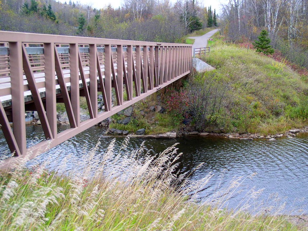
Gitchi-Gami State Trail bridge over Split Rock River, courtesy of Wikipedia.
Map of DOT Wayside to Park Road segment.
Map of Split Rock Lightstation to Park Road segment.
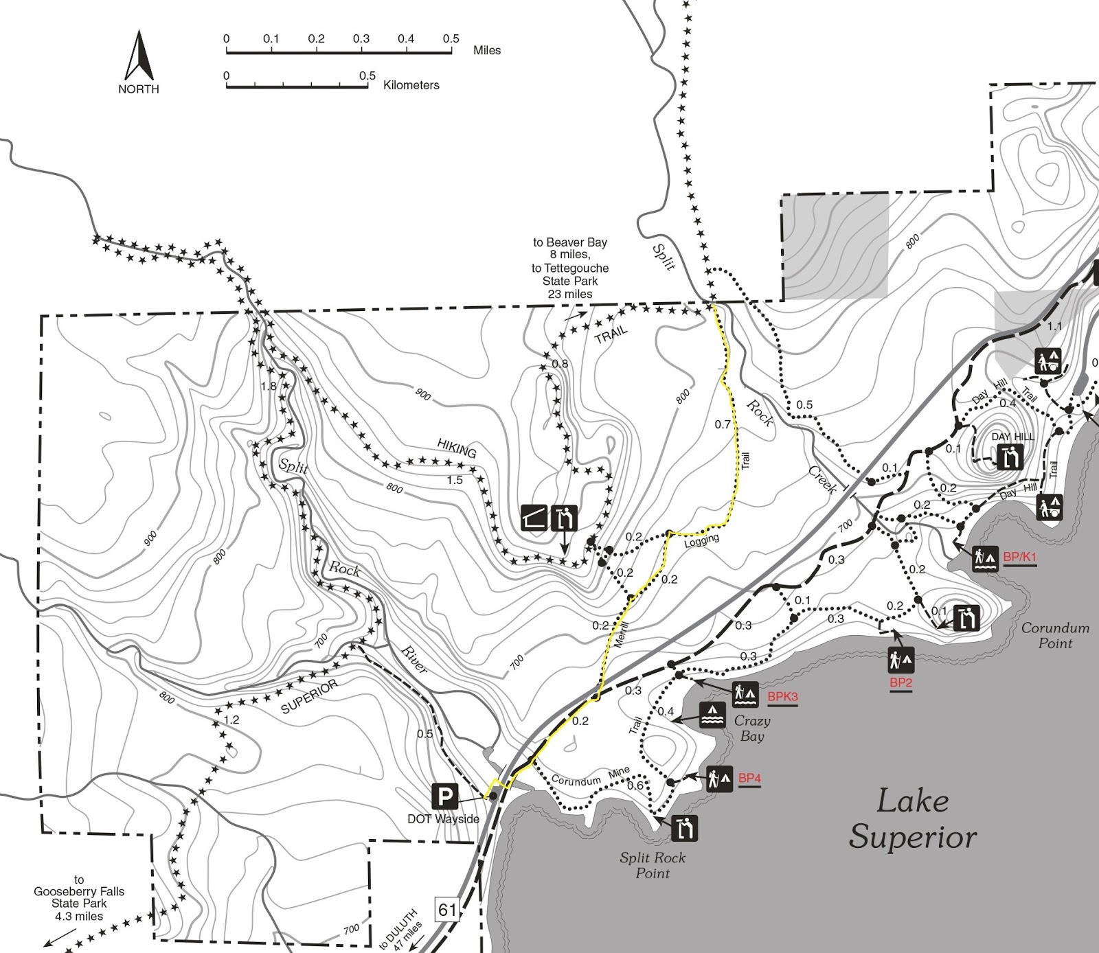
Map of Split Rock Lightstation to Gold Rock Point segment.
Click on maps for larger images.

Gitchi-Gami runs 3.8 miles through Minnesota park


Day hikers can get a good sense of what Minnesota’s Split Rock Lighthouse State Park is all about via the Gitchi-Gami State Trail, the only route that runs from one end of the park to the other.

Though primarily a bicycle trail, the paved Gitchi-Gami can be walked as well. When completed, the trail will run 88-miles from Two Harbors to Grand Marais. One of its longest finished sections runs from Gooseberry Falls State Park to Beaver Bay, which takes it straight through Split Rock.

The trail rambles about 3.8 miles across the park. If split up, three trail segments make for great day hikes.

DOT Wayside to Park Road segment
This 2.6-mile (one-way) section cuts across Split Rock’s southern half.

To reach the trailhead, from Two Harbors take Minn. Hwy. 61 about 21 miles north. At Split Rock Lighthouse State Park, park at the DOT wayside overlooking Split Rock River.

From the wayside, pick up the stem trail on the lot's west side, taking it under the highway to the trail, which runs between the highway and Lake Superior. There’s a small sand bar beyond the stem and the main trail’s intersection. A logging camp existed here in 1899-1906.

Go left/northeast on the main trail and cross the Split Rock River's mouth with Lake Superior. In short order, you’ll reach the junction with the Corundum Mine Trail. That trail explores the remnants of a mining operation from the early 1900s.

At 0.3 miles from the trailhead, the Gitchi-Gami junctions with the Merrill Logging Trail. The Merrill Logging Trail was built on an old railroad grade that brought white pine from the Arrowhead to Lake Superior.

In 0.9 miles from the trailhead, you’ll come across the junction with a connector trail that heads to the Corundum Mine Trail. At 1.2 miles is the junction with the other end of Corundum Mine Trail.

The Gitchi-Gami next crosses Rock Creek, which flows out of the highlands into Lake Superior.

On the other side of bridge is a connector leading to the Day Hill Trail. At 1.4 miles, you’ll come to yet another connector to that trail. Day Hill is a large block of erosion-resistant anorthosite that is more than a billion years old.

At 1.5 miles, the Gitchi-Gami reaches a three-way intersection with the Day Hill Trail. Go left/north and hike the backside of Day Hill and its base as you come back alongside Hwy. 61.

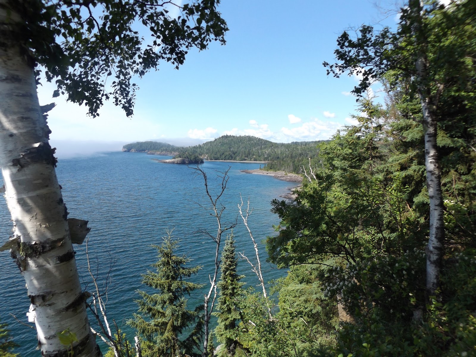
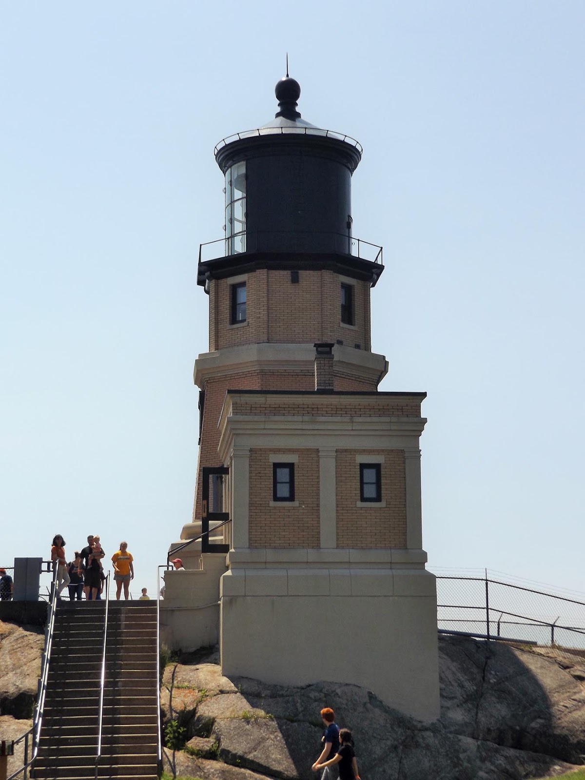
Along the way, you’ll a pass wayside for Hwy. 61. From the wayside, you’ll get an outstanding view of Split Rock Lighthouse, which was constructed on 1910.

At 2.6 miles, the Gitchi-Gami reaches the park road. Though you’ve hardly covered the length of the trail in Split Rock, this marks a good spot to turn back for a 5.2-mile round trip.

Split Rock Lightstation to Park Road segment
This 0.6-miles one-way hike (1.2-miles round trip) runs through the park’s center portion.

To reach the trailhead, enter Split Rock as if going to the lightstation and park in its lots. From the southwest lot, pick up the access trail. When the trail splits, go left/south-west.

The trail follows the park road then swerves away from it to near the Little Two Harbors Trail. The Little Two Harbors offers great views of Lake Superior and leads to a beach.

Next the Gitchi-Gami crosses a creek. When it arrives at the park road, you’ve reached the spot where the previous segment ended. This marks a good spot to turn back.

Split Rock Lightstation to Gold Rock Point segment
This 0.9-mile one-way (1.8-mile round trip) heads into park’s northern section.

Enter the park as if going to the Split Rock Lightstation and park in its lots. As in the previous segment, from the southwest lot, pick up the access trail. When the trail splits, however, go right/north-east and cross the park road.

The trail closely parallels the park road then Hwy. 61 for 0.8 miles, where it arrives at a parking lot. From the lot, a 0.1-mile spur trail heads to a bay west of Gold Rock Point.

After taking in the lake views, retrace yours steps back to the lot. Alternately, you can continue north/east from parking lot to park boundary, which is in 0.7 miles; that addition, which crosses two creeks, makes for a 3.2-mile round trip hike.

Final note: Though the trail runs through wooded areas its entire length in Split Rock, it is wide, so you’ll want to wear a sunhat and don sunscreen.

Learn about nearby hiking trails in Day Hiking Trails of Split Rock Lighthouse State Park.


Tuesday, February 16, 2016

Trail heads along beach south of lighthouse

Pebble Beach. Photo courtesy of MN DNR.
Map of trail, courtesy of MN DNR.

Little Two Harbors route
rambles through state park


Great views of a famous lighthouse and of Lake Superior from a pebble beach await on the Little Two Harbors Trail along Minnesota’s North Shore.

The 3.2-mile round trip trail ranks among the most popular at Split Rock Lighthouse State Park. To reach the trailhead, from Two Harbors take Minn. Hwy 61 north to the state park. Use the entry road and parking lots for the light station visitor center. Rather than go to the center, though, follow the trail heading southwest from the lot.

Initially, the trail offers access to a few of the light station’s historic sites. The first junction is for a path that loops back to light station while the second junction is with a trail heading to the lake. At both intersections, continue straight/west.

Pebble Beach
In short order, the trail curves southwest. It heads downhill over a wide trail with round cobbles on it; it is a terrace formed some 9000-10,000 years ago when Glacial Lake Duluth covered this area and was some 30-40 feet higher than Lake Superior is now.

When a footbridge crosses an intermittent creek, pause to look over the sides as the angular, step-like rocks of the rock outcrop. This is a distinctive type of basalt lava flow called Tortured Basalt because of the way the rock breaks off, which is due to weathering along the fractures crisscrossing it. The rock is best seen in late summer and autumn when water levels are low.

Asters bloom along the trail here during the same period. Most are white and purple. Bush honeysuckle and an impressive grove of birch trees also are present, as well as spruce trees.

As the trail arrives at the lake, it reaches Pebble Beach on Little Two Harbors. The protected cove is the perfect spot to take a safe swim in Lake Superior or to enjoy lunch; picnic tables are beyond the treeline along the beach. Three trail junctions across along the beach lead to the picnic area and a parking lot.

Trail's namesake
Be sure to take a gander north along the shoreline and you’ll be treated to a great view of the Split Rock Lighthouse. The century-old lighthouse sits atop Stony Point.

At the beach’s southwest end is the trail’s namesake, Little Two Harbors, where a small fishing village existed about a century ago. Ellingson Island sits just offshore, and the lighthouse still is visible.

After passing a portage route to the lake – the cove is popular with kayakers – the trail curves south. There’s a carry-in campsite in this area as well.

The junction with Day Hill Trail marks the end of the Little Two Harbors Trail. This is a good spot to turn back.

Learn about nearby hiking trails in Day Hiking Trails of Split Rock Lighthouse State Park.


Monday, February 8, 2016

Trail follows creek up Great Lakes bluffside

Juneberry fruits often are mistaken for blueberries.
Photo courtesy of Minnesota DNR.
Split Rock Creek Trail map, courtesy of Minnesota DNR.

Split Rock Creek Trail runs
2.5 miles in Minnesota park


Day hikers can explore a bluffside overlooking Lake Superior on the Split Rock Creek Trail at Minnesota’s Split Rock Lighthouse State Park.

The 2.5-miles round trip trail parallels Split Rock Creek. It’s one of the park’s less hiked trails and so offers a nice dose of solitude.

To reach the trailhead, from Minn. Hwy. 61 use the park’s main entry road for the historical lighthouse. Follow the road all the way to its end, where there’s a parking lot.

The trail leaves from the lot’s south side, heading to Lake Superior. Pass through the first junction then in 0.1 miles from the lot, at the second junction, go right/northwest on the Day Hill Trail. For the next 0.4 miles, the trail wraps around the hill’s northern base.

Upon reaching the paved Gitchi-Gami trail, go left/southwest for 0.15 miles. At the second intersection, go right/west; you’re now on the Split Rock Creek Trail.

Juneberries
Juneberry bushes grow in abundance for the next 0.1 miles as the trail reaches Hwy. 61. Sometimes called service berries, Saskatoon or shadbush, the fruit looks very similar to blueberries but tastes more like black cherries. The fruit typically ripens in late June to early July.

Carefully cross the busy highway and continue up the slope paralleling Split Rock Creek past birch and alder trees for the next 0.5 miles. The trail climbs more than 100 feet during that stretch.

A wide jeep trail, the Split Rock is wooded the entire way. Most of the stretch consists of spruce and maple with a large number of birch and balsam poplar dead or dying. Beneath the birch, look for flat-topped white, large-leaf, and pinnacled asters. These plants are typical of aging birch forests along Lake Superior.

Plants common in local grassy lawns have to be mowed in sections where they’re taking over the trail. Among them are buttercups, plantain, red and white clover, strawberries. Meanwhile, bracken fern, bush honeysuckle, large-leafed aster, and raspberries line the trail as it ascends.

Diabase and boulders
Geology-wise, the trail crosses an outcrop of diabase, a hard, erosion-resistant rock that has existed here for more than a billion years. A couple of the boulders in the outcrop that stand out consist of dark-colored schist and another of pink monzonite.

As gaining altitude, the trail pass white cedar with high branches. The lower ones all have been browsed by white-tailed deer.

One thing you won’t see too much of is Split Rock Creek, which mostly is separated from the trail by trees. Forming farther up in the highlands, the creek spills into Lake Superior between Split Rock and Corundum points. Some maps do not call Split Rock Creek – the stream actually has no official name – though locals have called it that since the 1920s, and most official Minnesota maps now refer to us as such.

After passing through a grove of large, aged cedars with younger, smaller balsam poplars, you’re closing in on the Superior Hiking Trail. At the SHT, turn back, retracing your steps back to the parking lot.

Learn about nearby hiking trails in Day Hiking Trails of Split Rock Lighthouse State Park.


Saturday, January 23, 2016

Trail follows historic rail line into bluffs

Map of Merrill Logging Trail.

Route heads through Split Rock state park


Day hikers can travel into the bluffs overlooking Lake Superior via a century-old railroad grade at Minnesota’s Split Rock Lighthouse State Park.

The Merrill Logging Trail, including an access trail from Split Rock River, runs 2.7-miles round trip. It crosses an area that many visiting the state rock bypass in favor of the historic lighthouse.

To reach the trailhead, from Two Harbors travel north on Minn. Hwy. 61. Park at the DOT Wayside for Split Rock River. From the lot, go north on walking path and take an immediate left/north onto the access trail for the Gitchi-Gami State Trail; this stem runs under the highway.

Once at the main trail, go left/northeast onto it. Follow it for 0.25 miles, then turn left/north onto the Merrill Logging Trail. A crossing of Hwy. 61 is required here, so be careful, as the road is busy.

Merrill Grade
Once across the highway, the grassy trail angles to the northeast into the woodline and climbs the Merrill Grade. Though steep, gaining about 150 feet in 1.1 miles, it is the easiest way to head up the bluffside.

From 1899 to 1906, the Merrill & Ring Lumber Company ran a logging camp at the mouth of the Split Rock River. A rail line headed 10 miles into the bluffs and backcountry, hauling timber to the river mouth. The trail follows a segment of that rail line.

About 0.2 miles from the Gitchi-Gami, the Merrill route reaches its first trail junction, a connector to the Superior Hiking Trail. Continue straight/northeast.

During the 1860s, Thomas Merrill – the product of a Maine lumber family – started a number of logging companies in Michigan. In 1886, he joined forces with Clark Ring, and they based their company out of Saginaw, Mich.

Split Rock Creek
In another 0.2 miles, the walking path junctions another connector to the Superior Hiking Trail. Go right/east here and continue up the bluff. In short order, the trail angles north.

As the white pine forests of the Great Lakes states thinned in the 1890s, Merrill & Ring purchased land in Washington state. In 1902, they moved their headquarters there.

About 0.7 miles from the last junction, the Merrill Logging Trail intersects the Superior Hiking Trail at Split Rock Creek. The creek rises from even higher in the bluffs, at an elevation more than 200 feet above this point.

The creek marks the park's northern boundary and the end of the Merrill Logging Trail. Turn back here, retracing your steps back to the wayside parking lot.

Learn about nearby hiking trails in Day Hiking Trails of Split Rock Lighthouse State Park.


Friday, January 15, 2016

Trail heads to fantastic Lake Superior vista

Map of Day Hill Trail
Routes lead to Day Hill summit at Split Rock


Hikers can head to what is arguably one of the Minnesota North Shore's best vistas on the Day Hill Trail at Split Rock Lighthouse State Park.

Two routes can take you to the top of this tall chunk of volcanic rock that sits over Lake Superior. The shorter out-and-back trail runs about 1.4-miles round trip while a longer lollipop trail runs about 1.8 miles.

To reach the trailhead, from Two Harbors, drive north on Minn. Hwy. 61 for 19 miles. Use the park entrance road for the lighthouse but continue driving southwest to the parking lot at its end. The Day Hill Trail leaves from the lot's south side. Art the first trail junction, continue straight/south.

Short route
At the next junction, go right/north. The well-groomed trail heads 0.4 miles around Day Hill's north side, gradually ascending the rock.

Day Hill is a large block of anorthosite, one of three in the park, the other two being Corundum Point and Stony Point. Formed 1.1 billion years ago, anorthosite lacks iron-bearing minerals so is highly resistant to erosion.

At the next junction, turn left/east. This goes a little under 0.2 miles to Day Hill’s summit where there’s an overlook. The summit sits at 840 feet elevation, about 240 feet above the lake.

From the slab of gray stone that makes up the overlook, vast blue Lake Superior stretches before you. The peninsula sticking into the lake to the southwest is Conundrum Point; to the northeast is Ellingson Island and Little Two Harbors with the lighthouse looming above the small bay. On a clear day, Wisconsin’s Apostle Islands can be seen about 20 miles to the southeast.

You'll also see the remnants of an old stone fireplace. Its origins remain a mystery, but legend says that around 1900, Duluth businessman Frank Day began building a house atop the rock for he and the woman of his dreams, but when she did not return his love, he gave up on the project.

Long Loop
The short route is only a segment of the Day Hill Trail. If you have more energy, rather than turning to head around the hill’s north side, instead continue straight/southwest and swing around Day Hill’s lake side.

After passing a spur trail to a cart-in campground on the lake, head right/north at the next junction. You’ll then travel along the hill's southwest side below its summit.

At the next junction, which is the Gitchi-Gami Trail, head right/northeast. Then take the next right/east trail to Day Hill's summit.

Upon coming down from the summit, go right/northeast to wrap around the base of the hill's north side. At the next junction, go left/east on the stem, heading back to the parking lot.

Learn about nearby hiking trails in Day Hiking Trails of Split Rock Lighthouse State Park.


Friday, October 23, 2015

Trail heads into red rock gorge, past falls

Split Rock River runs through a gorge of red rhyolite, 
volcanic rock that is 1.1 billion years old. 
Photo courtesy of Minnesota DNR.
Map of Split Rock River Trail, courtesy Minn. DNR.

Split Rock River Trail
popular at Minnesota
North Shore state park


A red rock gorge with waterfalls awaits day hikers of the Split Rock River Trail on Minnesota’s North Shore.

The 4.4-miles round trip trail sits in Split Rock Lighthouse State Park. Due to the great scenery and ease of access, it’s also among the Superior Hiking Trail’s most popular segments.

Split Rock Falls
To reach the trail, from Two Harbors, drive north on Minn. Hwy. 61. At mile marker 43.2, turn into the parking lot for the Split Rock River Wayside on the road’s north side.

The path heads up the west shore of Split Rock River through a birch grove on a spur trail. The spur is a gradual climb, offering nice views of the river valley below. Be aware that the clay banks on this side of the root beer-colored river at times are steep and after a rainfall can be slick; boardwalks, timbers and bridges make up part of the rugged trail’s surface.

At 0.5 miles from the trailhead, the spur reaches the junction with the actual Superior Hiking Trail; go right/north, remaining along the river. Watch for the blue blazes that mark the SHT.

A wooden bridge crosses the West Fork of the Split River, a small creek that drains into the main waterway, at about 0.8 miles from the trailhead. Large, mature cedars grow near the confluence, and a rock ledge allows a great place to rest and even enjoy a picnic as viewing Split Rock Falls, which tumbles 20 feet over gray rock.

Red rock gorge
From the creek, the trail swerves back to the river and enters a magnificent red rock gorge. The rock is rhyolite, a form of granite that appears red though its crystals are pink, black and white It formed during a massive lava flow 1.1 billion years ago.

A bare, shear five-story cliff of rhyolite is visible on the opposite shore. The green conifers atop this wall nicely contrast with the red rock.

Cascades and a small waterfall also can be found within the gorge.

Also among the highlights is the Pillars, twin chimneys of rhyolite. They sometimes are referred to as “Split Rock,” though that appellation probably came after the park was named. Passing the formation, look back as the pillars frame the waterfalls in the gorge.

Leaving the gorge, the trail levels out. At 2.4 miles, it reaches a bridge over the Split River; this marks a good spot to turn back to the parking lot.

Additional hike
If you have a little extra energy, consider making a loop around the river. Rather than turn back at the bridge, cross it to the river’s east side for a 5-mile round trip.

This trail on the eastern/northern shoreline is higher, staying above the gorge. Combined with the greater amount of sunlight the slopes on this side of the river receive, this is a drier portion of the trail. The cliffs also offer a unique vantage for seeing the Pillars.

The trail soon moves away from the river and climbs a bit higher to a ridgeline. The result is a wide, commanding view of Lake Superior with the Apostle Islands in the distance. A lean-to shelter is near this vista.

At 4.2 miles from the parking lot, the Superior Hiking Trail comes to a junction; take the spur trail right/southeast. The trail then makes a steep descent. At the bottom, you’ll cross Hwy. 61. From there, go left, southwest on the paved Gitchi-Gami Bike Trail.

The trail then crosses Split Rock as it spills into Lake Superior. Use the pedestrian tunnel to cross Hwy. 61 to your parking lot.

Learn about nearby hiking trails in Day Hiking Trails of Split Rock Lighthouse State Park.


Sunday, August 16, 2015

North Shore trail passes century-old ruins

Crazy Bay with Corundum Point in distance.
Photo courtesy of Minnesota DNR.
Corundum Point Trail map.

Split Rock Lighthouse park
route heads through
old logging, mining camps


Day hikers can explore the history of a wild Lake Superior shoreline at Minnesota's Split Rock Lighthouse State Park.

The Corundum Mine Trail runs 4.2-miles round trip. Besides being a back-to-nature hike, the trail passes ruins of old logging and an mining operations.

To reach the trailhead, take Minn. Hwy. 61 about 21 miles north from Two Harbors. At Split Rock Lighthouse State Park, park at the DOT wayside overlooking Split Rock River.

From the wayside, pick up the stem trail on the lot's west side, taking it under the highway to the paved Gitchi-Gami State Trail, which runs between the highway and Lake Superior. There's a small sand bar beyond the stem and the main trail's intersection.

Split Rock Point
Go left/northeast on the main trail and cross the Split Rock River's mouth with Lake Superior. Keep an eye out for the remains of pilings, a wharf, and a dam that once was part of the Split Rock Lumber Company's logging operations from 1899 to 1906.

At 0.2 miles from the parking lot, you'll reach the actual Corundum Mine Trail. Go right/southeast onto the path, as it edges a forested side of Split Rock Point. A post office and other buildings where the lumberjacks resided used to sit inland on the point.

The trail reaches an impressive overlook of Lake Superior at 0.7 miles from the wayside. A young lake, Superior formed when a massive glacier during the last ice age scooped out the soft sediment and then melted in the massive depression.

From the overlook, the trail cuts inland than passes Crazy Bay. A small cobblestone beach separates the woods from the lake, where seagulls soar overhead as Corundum Point rises out of the northeast. It's a great location for a picnic lunch. The spot is popular with kayakers, and there's a campsite for them at 1.2 miles from the trailhead.

Corundum Point
The trail remains close to the lakeshore the rest of the way. At 1.5 miles from the trailhead, it reaches a connecting trail with the Gitchi-Gami; continue going straight/northeast.

A knoll soon appears on the horizon. This is the peak on Corundum Point. At the 2-mile mark, the trail reaches the knoll’s base. Despite that glaciers have covered the point several times, the highly-resistant anorthosite rock survived.

The two large concrete footings along the trail are the remains of a crushing house built more than a century ago by the North Shore Abrasives Company. Many mistook the anorthosite for corundum, the hardest mineral after diamonds.

A steep 0.1-mile spur trail heads to an overlook atop the knoll. After taking in the view, retrace your steps back to the wayside parking lot.

Learn about nearby hiking trails in Day Hiking Trails of Split Rock Lighthouse State Park.


Sunday, June 29, 2014

Great Lake shoreline, historic lighthouse await Split Rock state park day hikers

Split Rock Lighthouse. Photo courtesy
of Wikipedia.
Vistas of Lake Superior’s rugged shoreline, a historic lighthouse, and glimpses of a century-old shipwreck await hikers at Split Rock Lighthouse State Park on Minnesota’s North Shore.

The state park is off of Minn. Hwy.61, about 20 miles north of Two Harbors, Minn. Some of the route heads along cliffs, so always keep an eye on children with you.

Lake Superior vistas
The largest freshwater lake in the world, Lake Superior, can be enjoyed along Split Rock Point via the 1.8-mile round trip Corundum Mine Trail. Park at the Hwy. 61 wayside immediately before Split Rock River; cross the highway and join the Gitchi-Gami State Bike Trail that goes over the river. After the bridge, take the first trail heading right/southeast, then follow the connector trail overlooking Crazy Bay.

A slightly shorter route is the 1.3-miles round trip Day Hill Trail, which heads to a summit overlooking the lake. Park at the lot at the end of Split Rock’s entrance road then take the stem trail south toward the lake. At the second junction, go right/northwest and head around the base of Day Hill, following the route to the summit.

Historic lighthouse
Day hikers can explore one of the nation’s most famous lighthouses and enjoy impressive cliff top views of Lake Superior on the Split Rock Light Station Trail. The 0.8-mile trail is a collection of walking paths around the historic Split Rock lighthouse. Perched atop a 130-foot high solid rock cliff overlooking Lake Superior, Split Rock is among the most photographed lighthouses in the country. The Minnesota Historical Society operates the 25-acre site in in the state park.

Madeiraa shipwreck
Take the Gitchi-Gami State Bike Trail north of the lighthouse to Gold Rock Point for a 4-mile round trip. On the point, you can look for agates and try to spot in the shallow water the remains of the cargo ship Madeiraa, which sunk here in 1905.

Learn about nearby hiking trails in Day Hiking Trails of Split Rock Lighthouse State Park.


Tuesday, June 24, 2014

Explore Split Rock Lighthouse via day hike

Split Rock Lighthouse.
Photo courtesy of Wikipedia.
Map of  Split Rock Light Station Trail, courtesy Minn. DNR.

Historic light station towers
154-feet above Lake Superior


Day hikers can explore one of the nation’s most famous lighthouses and enjoy impressive cliff top views of Lake Superior on Minnesota’s Split Rock Light Station Trail.

The 0.8-mile trail is a collection of walking paths around the historic Split Rock lighthouse. Perched atop a 130-foot high solid rock cliff overlooking Lake Superior, Split Rock is among the most photographed lighthouses in the country. The Minnesota Historical Society operates the 25-acre site in Split Rock Lighthouse State Park.

To reach the lighthouse from Two Harbors, drive north about 20 miles on Minn. Hwy. 61. Take the main park road to parking area for Split Rock Light Station and History Center.

Keeper’s house
Begin the hike at the parking lot’s southeast end by taking the walking path to the visitor center. After enjoying the exhibits, head back to the parking lot’s southwest end and go west on the Little Two Harbors Trail.

At the second junction, head south, taking the trail downhill to the pump house and the old dock location on the lake. When the lighthouse was being constructed and for almost a quarter century after its opening, it could only be reached by water.

Initially, this required that supplies be hoisted by crane from ships to the clifftop. By 1916, though, a tramway was constructed so that supplies could be brought up in a cart, with a gasoline engine powering the cables. Today, only the tramway’s concrete support piers stand.

Retrace your steps to Little Two Harbors Trail and head right/east. Take the next trail heading right/south. This passes two buildings of a private residence then the restored keeper’s home on the left/north.

Summer visitors can go inside the two-story brick house (It and two other grounds buildings are open from mid-May to mid-October, usually 10 a.m. to 6 p.m.). The cozy first floor consists of a kitchen, dining room and living room while the upstairs has three bedrooms and a bath. A cistern is in the cellar.

Lighthouse, fog-signal building
Leaving the keeper’s house, continue on the trail. Go right/south at the next junction to the brick fog-signal building and the lighthouse.

Visitors also can go inside the fog-signal building. When the light station opened more than a century ago, two six-inch sirens powered by a 22-horsepower gasoline engine, warned off ships that might not be able to see the lighthouse beacon due to fog.

Next to the fog-signal building is the lighthouse, which recently was restored to its pre-1924 appearance. Summer visitors can enter the octagonal brick tower, which was built around a steel framework. The lighthouse stands 54-feet high, with a lens manufactured in France that flashed every 10 seconds. Officially, the light could be seen up to 22 miles away, but fishermen in Grand Marais, Minn., more than 60 miles away, reported they could spot it on clear nights.

Take the walking trail north from the lighthouse and past the keeper’s home, as if heading to the visitor center. At the next trail junction, go right/southeast by the oil house.

As the trail reaches the cliff overlooking Lake Superior, the route curves north past the old hoist location. The hoist was used to supply the lighthouse until the tram opened, which in turn was displaced by the nearby highway.

That road wasn’t constructed until 1929, and even then a driveway to the lighthouse wasn’t built until 1944. Still, the road during the Great Depression began Split Rock’s tourism tradition. During 1938, close to 100,000 people visited the lighthouse by parking off the road and hiking to the site. It probably was the most visited lighthouse in America during that decade, the Coast Guard reported at the time.

Lake Superior views
Following the hoist site, go straight/north at the next junction for a grand view of Lake Superior. The world’s largest freshwater body of water, Lake Superior covers 31,700 square miles and reaches a depth of 1,332 feet.

After taking in the beautiful lake views, retrace your steps back to last trail junction. Once there, go right/west back to the parking lot.

The station officially closed in 1969, and in the decades since became a state park and a National Historic Landmark.

Visitors should note that while pets are allowed in the state park, they cannot go the historic area.

Learn about nearby hiking trails in Day Hiking Trails of Split Rock Lighthouse State Park.