Showing posts with label Grand Canyon National Park. Show all posts

Monday, October 30, 2017

Grand Canyon trail explores pueblo ruins

Day hikers can visit the ruins of an ancient pueblo and enjoy a fantastic vista of the Grand Canyon on the Walhalla Glades Pueblo Trail.

The trail runs 0.65-miles round trip. The Walhalla Glades Pueblo Trail technically is just the 0.2-mile round trip segment of the trail described here, but combining a spur and Walhalla Overlook turns it into a short walk.

Sometimes the route is simply referred to as the Walhalla Ruins Trail. Be advised that the road to the ruins and the overlook is closed October through May due to high elevation snow.

To reach the trailhead, from Ariz. Hwy. 67 on the park’s North Rim, turn east onto Cape Royal Road. The road winds its way through a small canyon before arriving at the rim. Look for the Walhalla Overlook parking lot on the road’s east side.

Cross the road to the Walhalla ruins. When the trail splits, go right/north.

The Grand Canyon has been inhabited for at least 3000 years. Around 1,200 years ago, during the Pueblo period, those living in the region began building masonry structures. At Grand Canyon, both ancestral Pueblo people and the Cohonina thrived in their own separate cultural groups. They left behind pottery, chipped stone, and the remains of their houses as a reminder of their time at the canyon.

These settlers lived at Grand Canyon for at least 500 years, with a way of life centered around farming, hunting and gathering. Their houses were constructed of stone and mud. Similar to modern-day pueblos, these houses were much sturdier than their previous dwellings, marking a major shift in the way they lived.

Summer home
The Walhalla Glades site served as a summer home to families for more than a century. Tucked away on the Walhalla Plateau, this wooded area was surrounded on three sides by the awe-inspiring Grand Canyon.

What makes this spot even more unique is its lower elevation compared to most of the North Rim. Thanks to updrafts of warm air from the inner canyon, this area’s winter snow melts earlier than other rim areas, making it the perfect place for ancestral people to farm.

More than 100 farm sites have been uncovered in this area, all dating to between A.D. 1050 and A.D. 1150. Small, one-room structures called field houses and agricultural terraces or garden plots, where crops like corn, beans and squash were grown, are found all across the plateau.

How many people lived at the Walhalla Pueblo at one time is unclear, but it doesn’t seem to have been more than twenty. The large rooms may have been used for living while the small rooms were most likely storage units. The four remaining structures were dedicated to the all-important task of food processing. Hikers on the nearby Cliff Spring Trail can get a glimpse of what one type of storage room, a granary, probably looked like.

Rooms A-B
During the harsh winter months, the inhabitants would retreat to the canyon, likely to a settlement called Unkar Delta along the Colorado River. Archaeological evidence paints a picture of a growing community struggling to feed its people. Perhaps that’s why the industrious settlers turned to farming the Walhalla Glades, as their primary source of sustenance could no longer provide for all of them.

The Walhalla pueblo consists of six common rooms that graced most of the structures of its time. The most ancient rooms that you will encounter are rooms A and B, with the latter being situated near the north wall.

Below these rooms are pits filled with debris, indicating that people occupied this site even before the Pueblo period. The walls of the rooms are made of shaped limestone slabs that rise from the ground level. The rock rubble in the rooms was once the upper walls that people built entirely of rock. Interestingly, the remains of adobe and beams inside the rubble reveal that the rooms were roofed, and people would enter through ladders.

A small slab-lined fire pit graces the north wall of room B, and this is one of eight hearths that were used for cooking and heating the rooms.

Rooms C-I
Rooms C and D provide a fascinating glimpse into the ancient architecture and construction techniques of their time. The use of large, unshaped limestone blocks set on edge is a testament to the ingenuity and skill of the builders. Interestingly, room D has a particularly unusual feature – a large limestone slab, also set on edge, which may have had a specific function. The presence of lichen growing on the rock adds to its mystery and intrigue.

Next are two small rooms known as Rooms E and F. Their size and location suggest that they likely were used for storage.

Rooms G, H, and I were less well-constructed than the larger ones. In fact, there’s evidence that these rooms may have been built and occupied by the last people to live at the site after the rest of it had burned down.

As walking back to the road, go on the trail branching right/east. This heads to the top of the same ridge as the ruins and offers a view into the some of the area the inhabitants of Walhalla likely hunted and foraged.

Walhalla Overlook
Return back to the parking lot. At its southeastern end is a short walkway to the Walhalla Overlook that offers a fantastic vista of the Grand Canyon.

Standing atop this overlook, a breathtaking view of a vast landscape unfolds before you. Echo Cliffs and the Painted Desert emerge in the distance, their vibrant colors and unique formations capturing your attention. As you take it all in, your gaze shifts southeast to the magnificent Little Colorado River Gorge, carving its way through the terrain with effortless grace.

Just below you in the canyon lies the Unkar Delta and Colorado River, both of which boast a rich cultural history with numerous archaeological sites and significant importance to the native people who once called this land home. It’s hard not to be inspired and humbled by such a magnificent display of nature’s beauty, with the surrounding drainages all feeding into Unkar Creek before eventually making their way into the mighty Colorado River.

Exploring this area, you can’t help but feel a sense of wonder and excitement for the rich history and natural wonders that await you.

TOPO MAP
Click for larger, printable version

Thursday, April 6, 2017

Great Hikes at Grand Canyon National Park

Grand Canyon National Park
Grandview Trail
Not all of the Grand Canyon National Park’s South Rim trails begin at Grand Canyon Village or require a shuttle to reach. Primary among them is the Grandview Trail. The steep trail heads into the canyon, connecting with other routes and offering interesting spurs. A segments of it can be done as a 2.2-mile round trip day hike, but you’ll need to be in shape, and any children with you will need to be in their teens. 

Grand Canyon Village hikes
Among the Grand Canyon National Park’s most spectacular sights can be seen on day hikes near Grand Canyon Village, the gateway to the South Rim. While each of the trails heads for several miles, each of them can be shortened into reasonable day hikes. The three major South Rim trails start near the village.

Hermit Trail trailhead
To get away from the crowds that frequent the popular Bright Angel and South Kaibab trails on Grand Canyon National Park’s South Rim, consider heading to the Hermit Trail trailhead for a couple of options.

Family Hikes on Grand Canyon Backcountry Trails
Many of the national park’s trails head into the backcountry by going up and down steep canyon sides, offering fantastic adventures for backpackers. That’s not so great for families, especially with small children, though, who often find themselves limited to the crowded paved rim trails. Still, a small segment of any of those backcountry trails can be done as a day hike.

BONUS: Play it safe on Grand Canyon hiking trails
With spring’s arrival, hiking trails across Grand Canyon National Park are opening. Many of these trails head into the backcountry and go up and down steep canyon sides. Still, a small segment of any of the trails can be done as a day hike. Whether doing a day hike or a backcountry hike, though, the Grand Canyon’s many trails always should be taken seriously. The park annually averages around 400 medical emergencies on trails while about 250 people need to be rescued (which the rescued hiker gets billed for, by the way). 

Learn more about national park day hiking trails in my Best Sights to See at America’s National Parks series.


Tuesday, November 8, 2016

13 Great Day Hikes in Arizona

Petrified National Park
Best trails to see Grand Canyon's wonders
Among the best ways to see Grand Canyon National Park’s top sights is via a day hike. Just four short walks will allow you to enjoy each of the park’s highlights – the Colorado River gorge, archeological and historical ruins, and incredible sunrises and sunsets.

Best trails to see Petrified Forest National Park’s wonders
Among the best ways to see Petrified Forest National Park’s top sights is via a day hike. Three short trails and one brief walk will allow you to enjoy each of the park’s highlights – petrified trees, painted deserts, ancient pueblos, and volcanic craters.

Great Logs Trail
Petrified Forest National Park
Families can hike the remains of a woodlands dating from the dinosaurs’ earliest days on the Great Logs Trail in Petrified Forest National Park. The fairly easy walk consists of two loops that combine for a 0.6-mile round trip. Because of the hot Arizona weather, spring and autumn mark the best time to hike the trail.

Best trails to see Saguaro National Park’s wonders
Among the best ways to see Saguaro National Park’s top sights is via a day hike. Just five short trails will allow you to enjoy each of the park’s highlights – towering saguaros, desert wildflowers, petroglyphs, the Javelina Rocks, and Sonoran Desert wildlife.

Tanque Verde Ridge Trail
Saguaro National Park
Among the most popular picnic spots in Saguaro National Park is the Javelina Rocks, located off of Cactus Forest Drive. Formed more than 25 million years ago, the rocks are an interesting example of Catalina Gneiss, in which sheets of other minerals were melted into one another while deep underground.

BONUS: How to avoid, treat hyponatremia on hike
If hiking in the desert or on an extremely humid day, beware of suffering from hyponatremia. This ailment – a low sodium blood level – has been on the rise, in fact, at Grand Canyon National Park.

Learn more about national park day hiking trails in my Best Sights to See at America’s National Parks series.


Thursday, October 6, 2016

Great Hikes on Grand Canyon's North Rim

To avoid crowds, try North Rim trails
As the South Rim of Grand Canyon National Park gets most of the press, the North Rim is just as beautiful. Fortunately, it also offers a number of great day hikes.In fairness, the South Rim is iconic and somewhat more accessible. But if coming from Utah and Colorado or all points north, the North Rim is fairly easy to reach. You’ll also find this side of the canyon much less crowded.

Widforss trails
Getting away from the Grand Canyon National Park’s crowds doesn’t mean require a backcountry hike far off the beaten path. Two long trails leaving from the North Rim’s Widforss parking area can be shortened into day hikes yet are within a few miles of the visitor’s center.

North Kaibab Trail trailhead
A great set of day hiking trails on the Grand Canyon National Park’s North Rim start at the North Kaibab Trail trailhead. After entering the park on Ariz. Hwy. 67, use the North Kaibab parking lot, which is immediately after the Forever Resorts Grand Canyon.

Cape Royal road trails
Plenty of North Rim trails can be day hiked without driving all the way to the Grand Canyon Lodge. A good set of them are along Cape Royal Road. Among them is the Roosevelt Point Trail, a 0.2-mile loop through a woodland along the rim, and the Walhalla Ruins Trail, a 0.2-mile round trip trail heading to an archeological site.

BONUS: Dogs allowed on North Rim trail
The usual wisdom is that to leave the family dog at home if traveling to a national park. There is some good news for hikers traveling with a dog to Grand Canyon National Park this summer, however.

Learn more about national park day hiking trails in my Best Sights to See at America’s National Parks series.


Thursday, July 16, 2015

Video of Grand Canyon’s Horseshoe Bend

Most people think the Grand Canyon’s best sites all sit north of Flagstaff. While those views and hikes are no doubt fantastic, there are scattered other spots that also offer breathtaking vistas.

One such site is the Horseshoe Bend Trail, which offers a perfect perch for enjoying the sunset.

The 1.5 miles-round trip heads over a rugged path of loose sand that goes downhill to a vista just north of the Grand Canyon National Park border. It’s located at the southern tip of the Glen Canyon National Recreation Area.

Here’s a time-lapse video of Horseshoe Bend at sunset:


To reach the trailhead, from Page, Ariz., drive south on U.S. Hwy 89. After passing the Ariz. Hwy. 98 intersection, watch for signs leading to a parking lot on the road’s right/west. The trail leaves from the lot’s northwest corner.

A small gazebo offers shade about 800 feet from the parking lot. At the vista, hikers can watch the Colorado River's deep blue water circle about a towering peninsula of beige and red sandstone.

The sheer cliff sports a 1000-foot drop-off, so don’t let kids get near the edge. In addition, the trail is located in a desert climate with no shade, so water, sunhat and sunscreen are recommended year around.

Read more about day hiking the Grand Canyon in my Hittin’ the Trail: Day Hiking Grand Canyon National Park guidebook.


Tuesday, May 5, 2015

Video of Grand Canyon NP rock formations

The Grand Canyon rightly defies description. Most who see it for the first time say it reminds them of a majestic painting, appropriately suggesting it’s a place that only can be visualized by actually gazing upon it.

But just how large is it?

Here’s a brief video that zooms out from a large rock formation in the canyon:


The entire canyon runs 277 miles from Lees Ferry south of the Utah-Arizona border to Grand Wash Cliffs near the Hoover Dam on the Nevada-Arizona border. It reaches 6000 feet deep from rim to canyon floor at its deepest, 18 miles across from rim to rim at its widest. And then there’s the unfathomable age of the rock, up to 2 billion years old.

To experience the Grand Canyon’s size, try any of these three must-do hiking trails at the national park:
g South Rim Trail (iconic canyon views)
g Bright Angel Trail (links South and North rims)
g Point Imperial Trail (North Rim views)

Read more about day hiking the Grand Canyon in my Hittin’ the Trail: Day Hiking Grand Canyon National Park guidebook.


Tuesday, September 23, 2014

Best trails to see Grand Canyon's wonders

Grand Canyon at sunset, from Mather Point.
Among the best ways to see Grand Canyon National Park’s top sights is via a day hike. Just four short walks will allow you to enjoy each of the park’s highlights – the Colorado River gorge, archeological and historical ruins, and incredible sunrises and sunsets.

Colorado River gorge
One of the Seven Natural Wonders of the World, the Grand Canyon’s immense size – 6000 feet deep from rim to canyon floor at its deepest, 18 miles across from rim to rim at its widest – appears unreal to most visitors. Then there’s the unfathomable age of the rock, up to 2 billion years old. While the South Rim Trail extends several miles along the canyon edge, the short eastern section is perfect for a day hike with children. They’ll be able to see the Colorado River a mile below and an array of incredible buttes, towers and ridges that stretch up to 10 miles away to the canyon’s other side.

Archeological ruins
Along the North Rims’ Cape Royal Road is the extremely short Walhalla Ruins Trail (0.2-miles), which heads to a site inhabited as long as 900 years ago. Ranger talks often are held at the overlook next to the trail’s parking lot; from the overlook, you can see the Unkar Delta of the Colorado River, which ancient Native Americans once farmed.

Historical building
Hermit’s Rest, a century-old building that originally served as a restaurant for a stop along the Atchison, Topeka and Santa Fe Railway, was designed so that from a distance it looked like a natural rock formation. From Hermit’s Rest, a segment of the South Rim Trail can be taken 1.1-miles to Pima Point, offering excellent views of the canyon bottom a mile below.

Sunrises…or sunsets
Mather Point boasts spectacular sunsets and sunrises for those willing to walk in the dark. From the El Tovar Hotel, hike a segment of the South Rim Trail about 2.45 miles one-way to the point. You either can go back the way you came or take a 0.25-mile spur to the Canyon View Information Plaza, where you can catch a shuttle to the lodges.

Read more about day hiking the Grand Canyon in my Hittin’ the Trail: Day Hiking Grand Canyon National Park guidebook.


Tuesday, September 2, 2014

Classic Grand Canyon sights an easy walk

The sun sets over Yavapai Point.
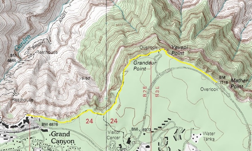
Topo map of South Rim Trail from El Tovar to Mather Point.

Head east from village along canyon rim


The Grand Canyon rightly defies description. Most who see it for the first time say it reminds them of a majestic painting, appropriately suggesting it’s a place that only can be visualized by actually gazing at it.

Among the canyon’s most spectacular sights can be seen within walking distance of Grand Canyon Village, the national park’s gateway to the South Rim. While the South Rim Trail extends several miles along the canyon edge, the short eastern section is perfect for a day hike with children. They’ll be able to see the Colorado River a mile below and an array of incredible buttes, towers and ridges and that stretch up to 10 miles away on the canyon’s other side.

Weather-wise, the best time to hike the trail is late May through summer. That’s also when the park is the busiest, so be prepared for crowds.

Arizona S.R. 64 provides the most direct route to the South Rim Trail. When arriving, park at the lodges in Grand Canyon Village, especially near the El Tovar Hotel.

The trailhead is behind the hotel's parking lot and heads roughly northwest toward the canyon rim. This really is just a spur leading from the lodges to the South Rim Trail. Upon reaching the rim trial, go right (or east). The trail is wide and paved. It’s also close to the canyon edge, so toddlers are best kept in child carriers.

Yavapai Point
The first 1.75 miles of the walk offer the classic striking views of the Grand Canyon. Most of the rock at the top of the canyon is 230 million years old, laid down when the first dinosaurs walked the earth. Each layer beneath the rim is progressively older, with the very bottom where the Colorado River flows some 2 billion years old, almost half of the Earth’s age.

Though the orange and brown striped canyon appears to be utterly desolate, the comforting scent of green Ponderosa pine and juniper fills the air along the rim. Pinyon pine, cactus and yucca generally live close to the canyon edge.

Looking out into the canyon, you may be lucky enough to spot the rare California condor. It’s the largest land bird in North America with a wingspan up to nine feet. You’re certain to spot ravens as well as canyon wrens and the brilliant blue Stellar’s jay. On the ground, expect to spy chipmunks, various small lizards, and the famous Abert's squirrel with its tufted ears. The squirrels and chipmunks have learned to beg for food, but as at a zoo don’t feed the animals. It’s unhealthy for them and potentially dangerous for you.

The crowds thin as you close on Yavapai Point, the first landmark and a good place to rest. The point’s observation station dates to 1928 and offers geology exhibits inside, making it a great place for the kids to learn a little science while getting out of the sun.

Mather Point
From Yavapai Point, you’ll walk 0.7 miles roughly southeast to Mather Point. Along the way, views of the canyon seem to shift like pictures in a marquee. The trail also is only a few feet from the edge at spots, so keep a very close eye on children.

Mather Point is a popular viewpoint, especially at sunset and sunrise, and a good place to rest.

The spot also is a good end point if you have preschoolers or early elementary school children. You either can go back the way you came or take a 0.25 mile spur to the Canyon View Information Plaza. At the plaza, you can catch a shuttle back to the lodges, a great relief to any tired little feet accompanying you.

For older children and teens, consider continuing on to Pipe Creek Vista. This marks the eastern terminus of the South Rim Trail, and as the road swerves away from the rim, you’ll find it very peaceful. The vista offers an impressive view of Pipe Creek, which merges with Garden Creek before flowing into the Colorado River. A shuttle is available at the vista for return to the lodges.

More:
Slideshow of day hike

Read more about day hiking the Grand Canyon in my Hittin’ the Trail: Day Hiking Grand Canyon National Park guidebook.


Sunday, October 6, 2013

Turn long Grand Canyon trails into day hikes

Grand Canyon National Park
This blog entry by Hikes with Tykes author Rob Bignell originally appeared in Seattle Backpackers Magazine.

The Grand Canyon is one of those rare landscapes that humbles a soul.

Its immense size – 6000 feet deep from rim to canyon floor at its deepest, 18 miles across from rim to rim at its widest – appears unreal to most visitors. Then there’s the unfathomable age of the rock, up to 2 billion years old. Or simply watch the ever-shifting light as the canyon’s mood rotates through the day, ranging from the mystical, multiple hues of sunrise and sunset, to the utterly stark harshness of its brilliantly lit desert walls at high noon.

Many of the national park’s trails head into the backcountry by going up and down steep canyon sides, offering fantastic adventures for backpackers. That’s not so great for families, especially with small children, though, who often find themselves limited to the crowded paved rim trails. Still, a small segment of any of those backcountry trails can be done as a day hike.

Primary among them on the South Rim is the Grandview Trail. A segment of it can be done as a 2.2-mile round trip day hike, but you’ll need to be in shape, and any children with you should be on your back or in their teens.

Following the western side of the ridge that extends northeast of Grandview Point, the trail quickly descends into the canyon. Logs and cobblestones make up the trail’s base during many sections.

Hikers first pass through Kaibab Limestone, formed some 245 million years ago during the Permian Era. This 300-feet thick layer of white to yellow rock once sat at the bottom of a warm, shallow sea that was much like today’s Caribbean.

About 1.1 miles from the rim, you’ll reach the Coconino Saddle, having descended 790 feet. The rock here formed about 270 million year ago. The impressive view below is of the upper valley of Hance Creek. Given the elevation you must hike to reach the rim, this marks a good turnaround point for day hikers.

On the North Rim, the North Kaibab Trail is the only maintained trail into the canyon. Day hike about 500 feet down in elevation, which alone is a steep trail at a high altitude covering about a 1.5-mile round trip. Children again will have to be on your back or older teens.

The trail descends from a montane forest, consisting of aspen, Douglas fir and ponderosa pine, into Roaring Springs Canyon. Meltwater flowing down this side canyon feeds the Colorado River.

As the trail winds downward, you’ll have gone about 500 feet below the rim in 0.75 miles of walking. At that point is the Coconino Overlook, where an excellent view of Roaring Springs Canyon awaits.

Turning back at the overlook is a good idea for day hikers. If early in the day, you may want to consider going a little farther down to the Supai Tunnel. A man-made passageway through the rock, reaching the tunnel makes for a 1.8-mile hike and about 1440 feet below the rim. Go ahead and walk through the small tunnel to see the looming cliffs with pinyon and juniper ahead.

Some other backcountry trails that you can shorten into great family day hikes include:
g South Kaibab Trail – On the South Rim, take the Kaibab Trail Route shuttle bus to the trailhead, which is east of the village and south of Yaki Point. While the trail goes for up to six miles round trip, you may want to shorten this steep walk by stopping after 0.75 miles (for 1.5 miles round trip) at Ooh-ahh Point, which is less than 200 feet below the rim. At the point, you round Yaki Point for a suddenly expansive view of the eastern canyon.
g Ken Patrick Trail – A short segment of this 10-mile (one-way) trail on the North Rim can be done through a forested area. About a mile from the North Kaibab parking lot, you’ll reach the junction for the Uncle Jim Trail; turn back here for a two-mile round trip. For families with older teens, you might consider extending the hike by taking part of the Uncle Jim route. A lollipop trail, combined with the Ken Patrick it runs 5 miles through woodland to Uncle Jim Point, a canyon overlook.
g Widforss Trail – Walk about a half-mile through aspen groves to the North Rim’s edge for a one-mile round trip. You’ll find that this trail is much less busy than those in the lodge area or those at the end of Cape Royal Road. The walk can be extended for several miles; if going the full length, the Widforss runs up to five miles one way with 350 feet in elevation change.

Read more about day hiking the Grand Canyon in my Hittin the Trail: Day Hiking Grand Canyon National Park guidebook.


Thursday, July 4, 2013

Shorten backcountry trips into day hikes at Grand Canyon National Park’s Widforss area

View of the Transept from Widforss Trail.
Photo courtesy Grand Canyon NPS.
Getting away from the Grand Canyon National Park’s crowds doesn’t mean require a backcountry hike far off the beaten path. Two long trails leaving from the North Rim’s Widforss parking area can be shortened into day hikes yet are within a few miles of the visitor’s center.

To reach the parking area, enter the park on Hwy. 67. About a quarter mile past the Cape Royal Road junction, turn right onto the dirt road. That first road ends at a parking lot in about a mile.

From the lot, two trails head into the backcountry.
• Widforss Trail – Walk about a half-mile through aspen groves to the canyon rim for a one-mile round trip. You’ll find that this trail is much less crowded than those in the lodge area or those at the end of Cape Royal Road. The walk can be extended for several miles; if going the full length, the Widforss runs up to five miles one way with a 350 feet in elevation change.
• South Kaibab Trail – For a real escape from the crowds, consider walking a little of this jeep trail, which heads north of the parking lot. In about 0.4 miles, you’ll reach the trail junction with the Point Sublime Trail; turnaround here for a 0.8-mile round trip. As both the South Kaibab and Point Sublime trails head into the backcountry, don’t go too far on either one.

Read more about day hiking the Grand Canyon in my Hittin’ the Trail: Day Hiking Grand Canyon National Park guidebook.


Thursday, June 20, 2013

Dogs allowed on some Grand Canyon trails

Dogs are allowed on the North Rim's Bridle Path at Grand Canyon
National Park. Photo courtesy of Grand Canyon NPS.
The usual wisdom is that to leave the family dog at home if traveling to a national park. There is some good news for hikers traveling with a dog to Grand Canyon National Park this summer, however.

Dogs and other pets are allowed in the park, though owners still must obey strict rules. First, dogs always must be on a leash no longer than 6 feet. In addition, they cannot go in hotel rooms or on park buses, so you may have to kennel them when you’re in those locations. Kennels (just for dogs and cats) are available only on the South Rim; there is a fee, and proof of vaccination is required. Leashed dogs are allowed at Desert View Campground, Mather Campground, Trailer Village, and the developed areas.

Queenie and Fido can go on a few park trails, if leashed. On the South Rim, those trails include any that are solely above the rim. On the North Rim, dogs are allowed only on the Bridle Trail connecting the lodge and the North Kaibab Trail and on the Arizona Trail continuing north from that point to the park entrance station. Dogs never are allowed below the rim.

Read more about day hiking the Grand Canyon in my Hittin the Trail: Day Hiking Grand Canyon National Park guidebook.


Saturday, June 15, 2013

Seattle Backpackers Magazine highlights best Grand Canyon day hikes

Seattle Backpackers Magazine on Thursday ran my article about family-friendly day hiking trails in Grand Canyon National Park. The article lists five trails – two on the South Rim and three on the North Rim – some of which take you along the canyon’s wooded edge and others that head into the canyon itself. The trails were drawn from my recent book, Hittin’ the Trail: Day Hiking Grand Canyon National Park.

Read more about day hiking the Grand Canyon in my Hittin the Trail: Day Hiking Grand Canyon National Park guidebook.


Monday, June 3, 2013

How to avoid, treat hyponatremia on hike

Hyponatremia is on the rise among desert hikers, such as
those at Grand Canyon National Park.
If hiking in the desert or on an extremely humid day, beware of suffering from hyponatremia. This ailment – a low sodium blood level – has been on the rise, in fact, at Grand Canyon National Park.

Sodium helps regulate the amount of water in and around your body’s cells; when it becomes too low, your cells swell with water, creating a variety of problems such as muscle spasms/cramps, loss of balance, nausea, confusion, fatigue and even death.

In deserts, this typically occurs because the heat causes people to sweat, resulting in a loss of sodium. When hikers drink water to replace the loss fluid, they aren’t replenishing their bodies with salt and other minerals, causing the sodium to become diluted and hence low.

To prevent hyponatremia, imbibe electrolyte drinks and tablets when hiking (sports drinks don’t contain enough electrolytes and so don’t work). Also bring salty food, such as beef jerky and sodium crackers with you. Continue to drink water, however, as your body still requires it in the dry heat.

If suffering hyponatremia, seek medical attention immediately. You will need intravenous fluids, restricted water intake and monitoring.

Read more about day hiking the Grand Canyon in my Hittin’ the Trail: Day Hiking Grand Canyon National Park guidebook.

Friday, May 31, 2013

Kid-friendly programs plentiful at GCNP

Grand Canyon National
Park Junior Park Ranger badge
Activities abound at Grand Canyon National Park to teach children about the natural wonder before them as well as the environment in general.

Among the kid-friendly programs are:
Junior Ranger – Children ages 4 and up can be sworn in as a Grand Canyon National Park junior ranger and receive a certificate by participating in several different programs. The most common way is to pick up a Junior Ranger Activity Booklet at a visitor center, complete it, and then attend a ranger-led program. Kids then receive a certificate and are sworn-in as junior park rangers during a ceremony. Presenting the certificate at a park gift store allows the child to purchase a junior ranger patch. During the summer, kids who participate in the Adventure Hike or Discovery Pack (ages 9-14) programs also can become junior rangers.
Ranger-led programs – A variety of programs meant specifically for children are held throughout the year on the South Rim and when open on the North Rim. Programs include short hikes, talks about condors, walks to fossil beds, and other presentations. A schedule for the various programs with their dates, times and locations, is available online.
Expeditions – Teenagers can sign up for multi-day camps in which they explore the canyon on a number of exciting adventures. The Rim to Rapids camp takes teens on a rapids ride and has them performing conservation field work. The Grand Inspiration camp involves teens drawing, painting, photographing and writing about the canyon as exploring it. Kids must apply for the camps through Grand Canyon Youth.

Read more about day hiking the Grand Canyon in my Hittin’ the Trail: Day Hiking Grand Canyon National Park guidebook.


Wednesday, May 29, 2013

Select from three trails at North Kaibab

Coconino Overlook on North Kaibab Trail, looking into Roaring Springs
Canyon. Photo courtesy of Grand Canyon NPS.
A great set of day hiking trails on the Grand Canyon National Park’s North Rim start at the North Kaibab Trail trailhead.

After entering the park on Ariz. Hwy. 67, use the North Kaibab parking lot, which is immediately after the Forever Resorts Grand Canyon.

From there, you can choose among three trails:
g North Kaibab Trail – The North Kaibab is the only maintained trail into the canyon from the North Rim. Rather than hike all the way to the bottom – which would require an overnight stay – hike about 500 feet down in elevation, which alone is a steep trail at a high altitude covering about a 1.5-mile round trip. The turn back point is the Coconino Overlook, where an excellent view of Roaring Springs Canyon awaits. While the North Kaibab is well-maintained, it’s also very steep with long drop-offs. Because of this, you won’t want to take young children on the trail.
g Bridle Path – The 1.2-mile trail (2.4-miles round trip) links the North Kaibab trailheads to the Grand Canyon Lodge. It parallels Hwy. 67 and typically is taken by those staying at the lodge to the North Kaibab trailhead. For travelers not staying at the lodge and who have dogs, this is a great trail as pets on leashes are allowed.
g Ken Patrick Trail – A short segment of this 10-mile (one-way) trail can be done through a forested area. About a mile from the parking lot, you’ll reach the junction for the Uncle Jim Trail; turn back here for a two-mile round trip. For families with older teens, you might consider extending the hike by taking part of the Uncle Jim route. A lollipop trail, combined with the Ken Patrick it runs five miles through woodland to Uncle Jim Point, a canyon overlook. To shorten the trip, go right where the trail’s loop begins; it’s then a little more than three miles when combined with the Ken Patrick.

Read more about day hiking the Grand Canyon in my Hittin’ the Trail: Day Hiking Grand Canyon National Park guidebook.


Wednesday, May 22, 2013

‘Hittin’ the trail’ guidebook on Grand Canyon National Park released

The second ebook in my Hittin’ the Trail series went on sale today. Hittin’ the Trail: Day Hiking Grand Canyon National Park offers the only complete list of day hiking trails in one of the nation’s favorite national parks. In addition, with one tap of the screen, you can:
g Plan days of fun family-friendly activities
g Reserve a campsite or lodging
g Receive a list of the parks’ current programs
g Learn about special kid programs
g Find directions, entrance fees, parking lots and more!

The book is available on Kindle, Nook/Kobo, iBook/iPad and other ereaders.

Read more about day hiking the Grand Canyon in my Hittin’ the Trail: Day Hiking Grand Canyon National Park guidebook.


Tuesday, May 21, 2013

Unique Grand Canyon views on North Rim

Point Imperial. Photo Courtesy Grand Canyon NPS.
For unique views of the Grand Canyon, consider hiking the Point Imperial Trail on Grand Canyon National Park’s North Rim.

To reach this part of the park, as driving south on Ariz. Hwy. 67, turn left onto Point Imperial Road about three miles before the visitor center/lodge. In 5.4 miles, turn left rather than onto Cape Royal Road.

The road ends after three miles at the Point Imperial parking lot, which offers picnic tables overlooking the eastern canyon from an altitude of 8803 feet. This is the highest of the North Rim vistas.

The trail leaves from the parking lot, heading along the canyon rim for two miles (four-miles round trip) through forestland destroyed during the 2000 Outlet Fire, though new aspen groves have taken root. The trail is fairly easy with only 100 feet in elevation change. It is part of the Arizona Trail.

Canyon views along Point Imperial Trail are somewhat different than what you’ll find on other trails at the national park. In this section of the canyon, the cliff walls are much closer together, so it appears to be a more conventional albeit deep gorge. Rising above the trail in the distance is Saddle Mountain.

A good turn back point is the trail’s terminus at the national park’s boundary. It can be extended, though, by taking Nankoweap Trail or Kaibab National Forest Road 610, but this isn’t recommended unless you plan to spend the night camping in the backcountry.

Read more about day hiking the Grand Canyon in my Hittin’ the Trail: Day Hiking Grand Canyon National Park guidebook.


Saturday, May 11, 2013

Walk through Permian Era remains on trail

Topo map of Grand Canyon's Grandview Trail.
View looking west from Grandview Point,
near Grandview Trail's trailhead. 
Not all of the Grand Canyon National Park’s South Rim trails begin at Grand Canyon Village or require a shuttle to reach. Primary among them is the Grandview Trail.

The steep trail heads into the canyon, connecting with other routes and offering interesting spurs. A segments of it can be done as a 2.2-mile round trip day hike, but you’ll need to be in shape, and any children with you will need to be in their teens.

To reach the trail, take Arizona Hwy. 64 (aka Desert View Drive) about 12 miles east of Grand Canyon Village. Leave vehicles in the Grandview Point parking lot. The trailhead is at the lot’s north end.

Shallow, Tropical Sea
Following the western side of the ridge that extends northeast of Grandview Point, the trail quickly descends into the canyon. Logs and cobblestones make up the trail’s base during many sections.

Hikers first will pass the Kaibab Limestone, formed some 245 million years ago during the Permian Era. This 300-feet thick layer of white to yellow rock once sat at the bottom of a warm, shallow sea, much like today’s Caribbean.

During the Permian, the world’s land masses formed a single supercontinent called Pangaea, which was surrounded by a single ocean, known as Panthalassa. The land began to dry as the first ancestors of mammals, turtles and dinosaurs dominated the earth.

Below the Kaibab, hikers walk through the 200-feet thick Toroweap Formation. The rock layer indicates that for several million years seas covered and retreated across the landscape, which during that period would have been a coastal area.

Age of the Dinosaurs
The rest of the trail segment descends through the Coconino Sandstone, formed as wind-blown sand covered a swampy floodplains over millions of years. Fossilized reptile tracks have been found in this layer of rock.

About 1.1 miles from the rim, you’ll reach the Coconino Saddle, having descended 790 feet. The rock here was formed about 270 million year ago. The impressive view below is of the upper valley of Hance Creek. Given the elevation you must hike to reach the rim, this marks a good turnaround point for day hikers.

The trail does continue for several miles, passing the abandoned Last Chance Mine, which at one time was owned by the prospector who actually constructed this path back in the 1890s. The copper mine sits on the Horseshoe Mesa another 1.9 miles from the saddle.

If taking Grandview Trail, be sure to wear a sunhat and sunscreen and to bring water. Hiking boots are a must. Finally, always remain cautious, as the trail isn’t maintained.

Read more about day hiking the Grand Canyon in my Day Hiking Grand Canyon National Park guidebook.


Thursday, May 9, 2013

Day hike North Rim’s Cape Royal road trails

Unkar Delta is framed through the natural arch
of Angels Window on the Cape Royal Trail.
Photo courtesy Grand Canyon NPS.
Plenty of North Rim trails at Grand Canyon National Park can be day hiked without driving all the way to the Grand Canyon Lodge. A good set of them are along Cape Royal Road.

To reach this part of the park, as driving south on Ariz. Hwy. 67, turn left onto Point Imperial Road about three miles before the visitor center/lodge. In 5.4 miles, turn right onto Cape Royal Road.

The Ken Patrick Trail crosses Cape Royal Road in about a half-mile. There’s no parking lot here but is a pullout area just south of the trail crossing; be careful of road traffic.

If taking the trail on the road’s left side, you’ll head just under three miles one way (slightly less than six miles round trip) briefly through an alpine forest and then along the canyon rim to Point Imperial. Picnic tables and restrooms make this a perfect stop for a midmorning snack or noontime meal with great views of the Painted Desert and Mount Hayden. The trail does continue heading north, but the point makes a good turnaround spot on what already is a long day hike.

Taking the trail on the road’s right side leads along the canyon rim to a small point overlooking Bright Angel Canyon in about a mile (two-miles round trip). While there are no facilities there, it offers a more “out in the wilderness” experience and at times can be difficult to follow. The trail does continue heading southwest along the rim, but the point makes a good turnaround spot.

Alternatively, you can skip the Ken Patrick Trail and take Cape Royal Road across a narrow isthmus, with the canyon on both sides, onto the Walhalla Plateau. You’ll pass Greenland Lake and Vista Encantada (which has picnic tables) before coming to Roosevelt Point. Park at the Roosevelt Point parking lot for the Roosevelt Point Trail, for a 0.2-mile loop through a woodland along the rim. Breaks in the trees frame great views of the canyon. Benches also are along the trail.

Continuing farther onto the plateau on Cape Royal Road brings you to Cape Final Trail. Running four miles round trip with 150 feet elevation change, the trail heads to a canyon overlook. The path is part of the Arizona Trail, which runs across from the state from the Mexico border to Utah.

A little farther along the road is the extremely short Walhalla Ruins Trail. From the Walhalla Overlook parking lot, a 0.2-mile round trip trail heads to the archeological site. Ranger talks often are held at the overlook, from which you can see a delta of the Colorado River, the Unkar Delta. Ancient Native American who once lived in the canyon farmed the delta.

About 0.75 miles south of that trailhead is Cliff Spring Trail. Park in the pullout; the trailhead is across the road. The one-mile round trip trail changes 600 feet in elevation but offers plenty of great sights. It begins by cutting into a forested ravine then parallels a sandstone wall with shade from overhangs. It ends in a fern oasis at a man-high boulder under an overhang; look for the spring between the boulder and sandstone wall. Though the water appears crystal clear, it can be contaminated, so do not drink it.

Cape Royal Road ends its 15-mile stretch by winding down to its namesake, Cape Royal, a peninsula sticking out the of Walhalla Plateau onto Bright Angel Canyon. The Cape Royal Trail takes you from the parking lot at the road’s end to farthest point on the peninsula, which sits at 7685 feet.

The 0.6-mile round trip paved trail is among the easiest walks of those in this section of the North Rim. Look for the trailhead at the Cape Royal parking area’s southeast side. The flat trail offers pleasant views of the canyon and the Colorado River with a short side trip to Angels Window. Interpretive markers about the area’s natural history line the trail. This path also is part of the Arizona Trail. There are picnic tables and restrooms here as well.

Be advised that a wildfire swept through this part of the North Rim in autumn 2011. Because of this, some trails and facilities may be temporarily unavailable to visitors.

Read more about day hiking the Grand Canyon in my Hittin’ the Trail: Day Hiking Grand Canyon National Park guidebook.


Friday, April 26, 2013

To avoid crowds, try North Rim trails

The view from Bright Angel Point. Photo courtesy Grand Canyon NPS.
As the South Rim of Grand Canyon National Park gets most of the press, the North Rim is just as beautiful. Fortunately, it also offers a number of great day hikes.

In fairness, the South Rim is iconic and somewhat more accessible. But if coming from Utah and Colorado or all points north, the North Rim is fairly easy to reach. You’ll also find this side of the canyon much less crowded.

To reach the North Rim, from Jacob Lake, Ariz., take Ariz. Hwy. 67 south about 40 miles to the North Entrance. You’re at a high altitude, about 8824 feet, but the summer sun still will be intense, so be sure to bring a brimmed hat and sunscreen with you; in addition, you’re still in a desert environment, so make sure you have filled canteens before any hike.

Most visitors to the North Rim stay at the Grand Canyon Lodge or one of the nearby campgrounds. The lodge and visitor center sits on a peninsula overlooking Bright Angel Canyon. From the lodge and center, you can access two trails:
g Bright Angel Point Trail – The 0.6-mile round trip takes walkers to the peninsula’s very tip, where they can enjoy a three-sided view of the canyon. Pick up the trail at either the log shelter by the visitor center or at the lodge’s back porch. Pamphlets describing the sights can be picked up from a box along the trial. The path is paved, but the 150-feet change in elevation can be taxing at that high altitude.
g Transept Trail – The three-mile round trip takes hikers on a narrow dirt trail along the canyon rim, connecting the Grand Canyon Lodge and North Rim Campground. While sections are shaded and cool air does blow up from the canyon, the 200 feet in elevation can be trying for those who aren’t physically fit.

Other trails are available along the North Rim but require driving to.

Read more about day hiking the Grand Canyon in my Hittin’ the Trail: Day Hiking Grand Canyon National Park guidebook.