Showing posts with label South Rim Trail. Show all posts

Tuesday, September 23, 2014

Best trails to see Grand Canyon's wonders

Grand Canyon at sunset, from Mather Point.
Among the best ways to see Grand Canyon National Park’s top sights is via a day hike. Just four short walks will allow you to enjoy each of the park’s highlights – the Colorado River gorge, archeological and historical ruins, and incredible sunrises and sunsets.

Colorado River gorge
One of the Seven Natural Wonders of the World, the Grand Canyon’s immense size – 6000 feet deep from rim to canyon floor at its deepest, 18 miles across from rim to rim at its widest – appears unreal to most visitors. Then there’s the unfathomable age of the rock, up to 2 billion years old. While the South Rim Trail extends several miles along the canyon edge, the short eastern section is perfect for a day hike with children. They’ll be able to see the Colorado River a mile below and an array of incredible buttes, towers and ridges that stretch up to 10 miles away to the canyon’s other side.

Archeological ruins
Along the North Rims’ Cape Royal Road is the extremely short Walhalla Ruins Trail (0.2-miles), which heads to a site inhabited as long as 900 years ago. Ranger talks often are held at the overlook next to the trail’s parking lot; from the overlook, you can see the Unkar Delta of the Colorado River, which ancient Native Americans once farmed.

Historical building
Hermit’s Rest, a century-old building that originally served as a restaurant for a stop along the Atchison, Topeka and Santa Fe Railway, was designed so that from a distance it looked like a natural rock formation. From Hermit’s Rest, a segment of the South Rim Trail can be taken 1.1-miles to Pima Point, offering excellent views of the canyon bottom a mile below.

Sunrises…or sunsets
Mather Point boasts spectacular sunsets and sunrises for those willing to walk in the dark. From the El Tovar Hotel, hike a segment of the South Rim Trail about 2.45 miles one-way to the point. You either can go back the way you came or take a 0.25-mile spur to the Canyon View Information Plaza, where you can catch a shuttle to the lodges.

Read more about day hiking the Grand Canyon in my Hittin’ the Trail: Day Hiking Grand Canyon National Park guidebook.


Tuesday, September 2, 2014

Classic Grand Canyon sights an easy walk

The sun sets over Yavapai Point.
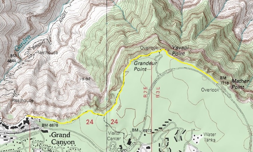
Topo map of South Rim Trail from El Tovar to Mather Point.

Head east from village along canyon rim


The Grand Canyon rightly defies description. Most who see it for the first time say it reminds them of a majestic painting, appropriately suggesting it’s a place that only can be visualized by actually gazing at it.

Among the canyon’s most spectacular sights can be seen within walking distance of Grand Canyon Village, the national park’s gateway to the South Rim. While the South Rim Trail extends several miles along the canyon edge, the short eastern section is perfect for a day hike with children. They’ll be able to see the Colorado River a mile below and an array of incredible buttes, towers and ridges and that stretch up to 10 miles away on the canyon’s other side.

Weather-wise, the best time to hike the trail is late May through summer. That’s also when the park is the busiest, so be prepared for crowds.

Arizona S.R. 64 provides the most direct route to the South Rim Trail. When arriving, park at the lodges in Grand Canyon Village, especially near the El Tovar Hotel.

The trailhead is behind the hotel's parking lot and heads roughly northwest toward the canyon rim. This really is just a spur leading from the lodges to the South Rim Trail. Upon reaching the rim trial, go right (or east). The trail is wide and paved. It’s also close to the canyon edge, so toddlers are best kept in child carriers.

Yavapai Point
The first 1.75 miles of the walk offer the classic striking views of the Grand Canyon. Most of the rock at the top of the canyon is 230 million years old, laid down when the first dinosaurs walked the earth. Each layer beneath the rim is progressively older, with the very bottom where the Colorado River flows some 2 billion years old, almost half of the Earth’s age.

Though the orange and brown striped canyon appears to be utterly desolate, the comforting scent of green Ponderosa pine and juniper fills the air along the rim. Pinyon pine, cactus and yucca generally live close to the canyon edge.

Looking out into the canyon, you may be lucky enough to spot the rare California condor. It’s the largest land bird in North America with a wingspan up to nine feet. You’re certain to spot ravens as well as canyon wrens and the brilliant blue Stellar’s jay. On the ground, expect to spy chipmunks, various small lizards, and the famous Abert's squirrel with its tufted ears. The squirrels and chipmunks have learned to beg for food, but as at a zoo don’t feed the animals. It’s unhealthy for them and potentially dangerous for you.

The crowds thin as you close on Yavapai Point, the first landmark and a good place to rest. The point’s observation station dates to 1928 and offers geology exhibits inside, making it a great place for the kids to learn a little science while getting out of the sun.

Mather Point
From Yavapai Point, you’ll walk 0.7 miles roughly southeast to Mather Point. Along the way, views of the canyon seem to shift like pictures in a marquee. The trail also is only a few feet from the edge at spots, so keep a very close eye on children.

Mather Point is a popular viewpoint, especially at sunset and sunrise, and a good place to rest.

The spot also is a good end point if you have preschoolers or early elementary school children. You either can go back the way you came or take a 0.25 mile spur to the Canyon View Information Plaza. At the plaza, you can catch a shuttle back to the lodges, a great relief to any tired little feet accompanying you.

For older children and teens, consider continuing on to Pipe Creek Vista. This marks the eastern terminus of the South Rim Trail, and as the road swerves away from the rim, you’ll find it very peaceful. The vista offers an impressive view of Pipe Creek, which merges with Garden Creek before flowing into the Colorado River. A shuttle is available at the vista for return to the lodges.

More:
Slideshow of day hike

Read more about day hiking the Grand Canyon in my Hittin’ the Trail: Day Hiking Grand Canyon National Park guidebook.


Wednesday, April 24, 2013

Avoid GCNP crowds at Hermit’s Rest

Pima Point on South Rim Trail. Photo courtesy of Grand Canyon NPS.
To get away from the crowds that frequent the popular Bright Angel and South Kaibab trails on Grand Canyon National Park’s South Rim, consider heading to the Hermit Trail trailhead for a couple of options.

During April to October, take the shuttle bus from Grand Canyon Village to Hermit’s Rest (Personal vehicles may be driven and parked there, though, if you have a handicap permit.). Hermit’s Rest is a century-old building built as a restaurant for a stop along the Atchison, Topeka and Santa Fe Railway. It was designed so that from a distance it looks like a natural rock formation and now serves as a small gift shop and snack bar.

From Hermit’s Rest, you have two day hike options:
g Rim Trail segment – Sometimes referred to as the South Rim Trail, the trail runs 13 miles past Grand Canyon Village to the South Kaibab trailhead but can be shortened to a 1.1-mile trek to Pima Point. This option is perfect if you have younger children or are carrying them on your back. The dirt trail is fairly flat and offers excellent views of the canyon a mile below. At Pima Point, you can pick up a shuttle back to the village or return for a 2.2-miles round trip.
g Hermits Trail segment – The 8.9-mile backcountry trail easily can be shortened for a scenic 1.2-mile day hike to the Waldron Trail junction (2.4-miles round trip). The trailhead is about 500 feet west of Hermits Rest. Children hiking the trail should be fit teenagers as it’s a steep walk back up; the unmaintained trail descends 1240 feet into the canyon.

Read more about day hiking the Grand Canyon in my Hittin’ the Trail: Day Hiking Grand Canyon National Park guidebook.


Thursday, April 18, 2013

Shorten South Rim trails into day hikes

Cedar Ridge as seen from Oooh-Ahh-Point
on the South Kaibab Trail.
Among the Grand Canyon National Park’s most spectacular sights can be seen on day hikes near Grand Canyon Village, the gateway to the South Rim. While each of the trails heads for several miles, each of them can be shortened into reasonable day hikes.

The three major South Rim trails near the village include:
Bright Angel Trail – You’ll find the trailhead at Bright Angel Lodge near the mule corral. While the trail heads 13.6 miles round trip into the backcountry, day hikers can turnaround after 1.5 miles (for three miles round trip) at the Mile-and-a-half Resthouse after descending 1063 feet. The trail is very steep, with 10 percent average grades and if children are with you, is best for older teens.
South Kaibab Trail – Take the Kaibab Trail Route shuttle bus to the trailhead, which is east of the village and south of Yaki Point. While a the trail goes for up to six miles round trip, you may want to shorten this steep walk by stopping after 0.75 miles (for 1.5 miles round trip) at Ooh-ahh Point, which is less than 200 feet below the rim. At the point, you round Yaki Point for a suddenly expansive view of the eastern canyon. Most elementary school-aged kids can handle this trail.
South Rim Trail – While the South Rim Trail extends several miles along the canyon edge, the short eastern section is perfect for a day hike with children of any age. They’ll be able to see the Colorado River a mile below and an array of incredible buttes, towers and ridges that stretch up to 10 miles away on the canyon’s other side. Access the trail at any viewpoint in the village or on Hermit’s Road.

Read more about day hiking the Grand Canyon in my Hittin’ the Trail: Day Hiking Grand Canyon National Park guidebook.