Showing posts with label Big Bend National Park. Show all posts

Friday, August 21, 2015

Aerial vid of Rio Grande in Bend Bend N.P.

Rio Grande runs through Santa Elena Canyon. Photo courtesy of NPS.
The mighty Rio Grande defines Big Bend National Park, carving through the desert landscape as offering a score of recreational opportunities from river rafting to hiking.

Map of Santa Elena Canyon Trail
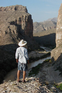
Day hikers can enjoy great views of and get up close to the Rio Grande on the Santa Elena Canyon Trail near the park’s center. From the Castolon Visitor Center, travel northwest on the Ross Maxwell Scenic Drive. Before hiking, though, stop at the Santa Elena Canyon Overlook for a view of the Rio Grande about 60 feet below.

Where the scenic drive ends, the trail begins. It first crosses the Terlingua Creek, then ascends via paved steps to a vista of the river. Next it heads into the canyon until the walls – which soar nearly 1400 feet overhead – meet the Rio Grande.

Overall, about 118 miles of the Rio Grande runs through Big Bend National Park. Here’s an aerial video of the Rio Grande in the park:


Also see: 
• Best trails for seeing Big Bend’s wonders

Learn about trail guidebooks available in the Hittin’ the Trail series.


Tuesday, April 22, 2014

Hike famous Rio Grande at Big Bend N.P.

The Rio Grande in Boquillas Canyon.
Among the best ways to see Big Bend National Park’s major sights is via a day hike. Though the park is vast, three short trails will allow you to enjoy the park’s major highlights – the Rio Grande River, some of America's darkest skies, and a historic Native American route.

Rio Grande
The Rio Grande stands as the international border between the United States and Mexico for more than a thousand miles. About a tenth of that border is within the national park boundaries. The Boquillos Canyon Trail near Rio Grande Village allows day hikers to wade into the river and to enjoy some of the intriguing landscape the waterway has carve through the Chihuahuan Desert.

Starry, starry night
Designated an “International Dark Sky Park,” Big Bend boasts among the darkest measured skies of the continental United States. Some nights, the Milky Way band is starkly visible. The Window View Trail in the Chisos Basin marks a great spot for some stargazing.

Great Comanche Trail
During the mid-1800s, Comanche and Kiowa Indians annually traveled this Great Plains-Mexico route, usually on raids. One of those fords over the Rio Grande is the Grand Indian Crossing. The same path can be hiked today on the 1.4-mile (one way) jeep trail heading south to Solis Campground, just upstream from Mariscal Canyon; be forewarned that upon leaving the paved highway, a four-wheel drive vehicle is needed.

Learn about other great national park day hiking trails in my Best Sights to See at America’s National Parks guidebook.


Thursday, August 30, 2012

Photos (3D!), map of Boquillas Canyon Trail

Caves the size of auto show rooms and the Rio Grande await intrepid travelers who hike the Boquillas Canyon Trail in Bend Bend National Park.

The park preserves more than 1,200 square miles of the Chihuahuan Desert along the international border with Mexico, marked by the Rio Grande. The easy 1.4-mile long trail takes you right up to the river border through Boquillas Canyon, one of park’s three largest canyons.

To reach the trail, from U.S. Hwy. 385, take Park Route 12 to Rio Grande Village then turn onto Boquillas Canyon Road. The parking area and trailhead is at the road’s end.

The Boquillas Canyon Trail heads over a low limestone hill, descends to the Rio Grande’s banks, then skirts the river shoreline:


Map of the trail:


Before arriving at the trail, considering pulling off into the overlook for a view of the canyon (photo courtesy of Big Bend NPS):


Sign at trailhead (showing there's plenty of bird life in the canyon):


Spring flowers bloom in this 3D photo of the trail leading into the canyon (photo courtesy USGS):


Gravel bar along the Rio Grande in a 3D photo of the trail inside the canyon (photo courtesy USGS):


Boca, or a weathered cave, in the limestone cliff, in a 3D photo of the trail inside the canyon (photo courtesy USGS):


Here's a full description of the trail.

Learn about other great national park day hiking trails in my Best Sights to See at America’s National Parks guidebook.


Tuesday, November 1, 2011

Caves, sand hills await in Boquillas Canyon

Boquillas Canyon Trail
Caves the size of auto show rooms and grand views overlooking the Rio Grande await intrepid travelers who hike the Boquillas Canyon Trail in Big Bend National Park.

The park preserves more than 1,200 square miles of the Chihuahuan Desert along the international border with Mexico, marked by the Rio Grande. The trail takes you right up to the river border through Boquillas Canyon, one of park’s three largest canyons.

There’s a narrow window for visiting the park. During late spring, summer, and early fall, midday temperatures often climb above 100 degrees F, though even then walks can be comfortably taken during early morning hours. March typically is the driest month, and the days just before April typically are the best to visit.

Descending to Rio Grande
The trail sits in the park’s eastern side. From U.S. Hwy. 385, take Park Route 12 to Rio Grande Village (where there’s a visitor center, though it’s closed during the summer), then turn onto Boquillas Canyon Road. There’s a viewing point on the way to the trail that is worth a stop. The parking area is at the road’s end. You’ll find the trailhead at the parking lot.

The easy 1.4-mile long trail largely is a fine sand surface and takes you back into Boquillas Canyon. The beginning of the trail consists of wooden planks and heads through flat desert scrub. Look for yucca and prickly pear cacti with its fruits.

The trail then heads over a low limestone hill, descending to the Rio Grande’s banks. Watch for the Indian mortar holes. There is also archeological evidence of pre-historic human inhabitation in the canyon.

This riverside section of the trail is lush and green, a respite from the stark desert that you drove through to reach Rio Grande Village and the trail. A variety of birds call the river shore home, and with the area’s remoteness, you’re certain to hear any number of songs, including those of the ash-throated flycatcher, black phoebe, black-throated sparrow, blue-winged teal, canyon towhee, cactus wren, chipping sparrow, common raven, house finch, Inca dove, ladderback woodpecker, loggerhead shrike, meadowlark, mockingbird, rock wren, rough winged swallow, turkey vulture, vermillion flycatcher, verper sparrow, white-wing dove, and the yellow rumped warbler. And yes, you’ll likely spot a roadrunner.

Boca
The trail from here largely skirts the river. The clear water offers inspiring reflections of canyon walls. Don’t be surprised if you also catch sight of a river rafting group navigating its way into the canyon or a rider stopping to let his horse drink from the river.

At the trail’s end is series of wind-driven sand hills and a shallow cave. Your feet will sink in the sand hills, which can make for some fun sliding. The cave is a boca, or a weathered cliff, and stretches several stories high in sediment laid down over tens of millions years when this area was under a shallow sea.

Be forewarned: You are in a very remote area. There is no cell phone coverage. In addition, you’re walking through the desert. For half-day hikes, you should carry at least 2 quarts of water per person. Springs and tinajas – the depressions in rock where water collects – typically are unsafe to drink from.

The good news is that if you should be injured, someone likely will be along soon. Locals from Mexico often cross the shallow river to sell trinkets and handiwork. Technically, it is illegal to purchase their goods. It’s also illegal to cross the border into Mexico by fording the river (and in any case, fording a river with children is unsafe).

Learn about other great national park day hiking trails in my Best Sights to See at America’s National Parks guidebook.