Showing posts with label Big Bay State Park. Show all posts

Wednesday, October 15, 2014

Variety of trails explore Wisconsin’s beautiful Madeline Island

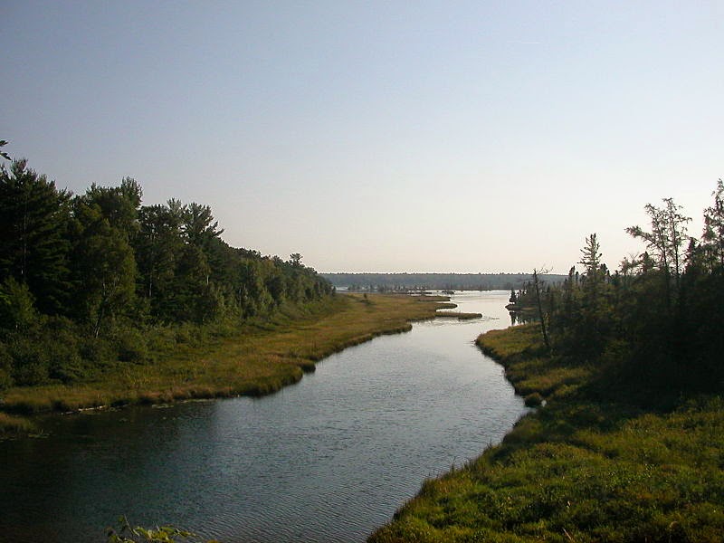
Big Bay Lagoon in Big Bay State Park. Photo courtesy of Wikimedia.

Three public
areas offer
hiking paths


Impressive Lake Superior vistas, beach walks, and old logging roads await day hikers on Madeline Island in northern Wisconsin.

The largest of the 22 Apostle Islands, Madeline Island offers three major parks – Big Bay State Park, the Madeline Island Wilderness Preserve (for which a north and a south unit exist), and Big Bay Town Park – each with trails. Most reach the island via a ferry ride from Bayfield, Wis., but other boat docking and even air transportation is available.

Among Madeline Island’s major trails are:
g Bay View Trail – Incredible views of Lake Superior await hikers on this Big Bay State Park trail. Adding the Boardwalk Trail on the sand spit turns this into a 5-mile round trip, though that can be cut in half if turning around at the boardwalk.
g Big Bay Town Park Trail – The trail heads east from the park entry road to a bridge that connects with a sand spit and beach along Big Bay. The beach trail can be followed south for about 0.2 miles to Big Bay State Park and then extended by connecting with the aforementioned Boardwalk Trail.
g Capser Trail – The 2-mile one-way trail runs between a parking area on Middle Road/Chebomnicon Road and County Road H/Big Bay Road in the Madeline Island Wilderness Preserve as part of the Madeline Island Ski & Hiking Trail South Section. A stem trail leads to an observation deck overlooking a wetlands.
g Lagoon Ridge Trail – The 2.6-mile round trip trail heads from Lake Superior around Big Bay Lagoon to a camping area on Big Bay State Park’s northern side. A good portion of it runs atop a ridge overlooking the lagoon and the Great Lake.
g North End Trail – Logging roads and old survey lines have been reclaimed as a trail that with its side loop runs up to 7 miles long in the Madeline Island Wilderness Preserve. Three trailheads access the collection of loops and stems that also are collectively known as the Madeline Island Ski & Hiking Trail North Section.
g Nucy Meech Trail – The Capser Trail can be extended 0.85 miles by taking this narrow path in the Madeline Island Wilderness Preserve’s southern unit. It’s being used to monitor the spread of buckthorn, barberry and other invasive species on the island.
g Point Trail and Point Trail Loop – Point Trail and a portion of the Point Trail Loop skirt the Lake Superior shoreline with a beach area for a 1.7-mile hike in Big Bay State Park. Access the trail from the parking lot for the Point Picnic Area.

Learn about trail guidebooks available in the Hittin’ the Trail series.


Monday, July 28, 2014

Best trails for seeing wonders of Wisconsin’s Big Bay State Park

Boardwalk Trail
Among the best ways to see the top sights in Wisconsin’s Big Bay State Park is via a day hike. Just three short trails will allow you to enjoy each of the park’s highlights – fantastic Lake Superior views, a romantic sunset, and a barrier beach pine forest.

Lake Superior views
Stretching for 31,700 square miles east and north of Madeline Island is Lake Superior, the world's largest freshwater lake, at least by surface area. Point Trail and a portion of the Point Trail Loop skirt the shoreline with a beach area for a 1.7-mile hike.

Romantic sunset
On a clear evening, the sunset casts Lake Superior in a golden glow that darkens with the sky from orange to purple to midnight blue, a perfect hour to spend with your loved one. Though facing east, the 1.3-mile Bay View Trail marks a good location to cuddle and watch Mother Nature’s free light show.

Barrier beach pine forest
Barrier beaches are common along the Atlantic coastline, and a microcosm of one with its own forest of red and white pines sits on Madeline Island. The 0.5-mile Boardwalk Trail heads through the woodlands on Big Bay Sand Spit.

Find out about trail guidebooks available in the Hittin’ the Trail series.


Monday, March 18, 2013

Follow island shoreline with Lake Superior

Big Bay State Park on Madeline Island.
Incredible views of Lake Superior await hikers traveling to Big Bay State Park in northern Wisconsin.

The park sits on Madeline Island, the largest of the famous 22 Apostle Islands. Taking the Bay View Trail along with a border a self-guided interpretive trail is a 5-mile round trip, though this can be cut in half by turning around at the boardwalk.

To avoid the Northwoods cold, visit in June and July. You’ll have to first load your vehicle aboard the Madeline Island Ferry, which runs every half hour from Bayfield on the mainland to La Pointe on the island. After a 20-minute ride across the lake, take County Road H east for about four miles. Turn right/east on Hagen Road. The park entrance is in 2 miles; you’ll need to pay an entry fee.

Continue on the park entry road (aka Haines Road), then turning right onto Wilderness Road. Where the road loops is a parking lot. The trailhead is on the lot’s east side.

An easy, well-maintained trail, you’ll pass Point Picnic Area to the edge of Madeline Island. At one time, the island – as well as the other Apostle Islands – was part of the mainland. Four sets of glaciers during the past 100,000 years and the ensuing lakes have eroded the 600 million-year-old sedimentary rock and formed the islands.

Sunsets and glaciers
At the T-intersection with Lake Superior before you, go left onto Bay View Trail (to the right is Point Trail). The wooded trail hugs the shoreline. You’re certain to spot wildlife and likely will see some bluff caves. If staying overnight, do the trail at the sunset – you won’t be disappointed by the spectacular views over Lake Superior’s Big Bay.

The largest of the Great Lakes sits atop hard basalt that formed 1.1 billion years ago when the North American continent literally was splitting. Eventually this separation stopped, and the rift filled with sediment. Glaciers during the last Ice Age excavated these deposits and left the cold water that forms the lake.

As rounding the shoreline, Bay View Trail turns into Lagoon Ridge Trail; follow this for a few yards to the Boardwalk. If short on time or tired, you may want to turn back here. If the day is young and you’re full of energy, go right, continuing along the boardwalk, which cuts through a white and red pine forest sitting upon Big Bay Sand Spit. Bearberry and wintergreen grows beneath the pines.

Nicely flat, the half-mile boardwalk offers benches for resting, interpretive signs and more impressive lake views. A lagoon sits to the boardwalk’s left.

Barrier beach
Some 15,000 years ago when Madeline Island reappeared as the glaciers retreated and melted, the lagoon didn't exist and was part of Big Bay. Since then, wave action and lake currents built a pair of barrier beaches, creating the lagoon.

The boardwalk turns into the self-guided nature trail that runs up the spit. You may want to take a break along the beach for a swim.

The nature trail includes a couple of small loops in it. Watch for bald eagles that nest and raise their younglings in the park. Upon reaching the trail’s end, turn around and return the way you came.

Before coming to the island, make sure you bring insect repellent. Bugs can be bothersome in the trail’s forested sections, and repellent sometimes can be difficult to find on the island.

Learn about trail guidebooks available in the Hittin’ the Trail series.