Showing posts with label Amery. Show all posts

Saturday, January 31, 2015

Photo album: Cattail State Trail in Amery, WI

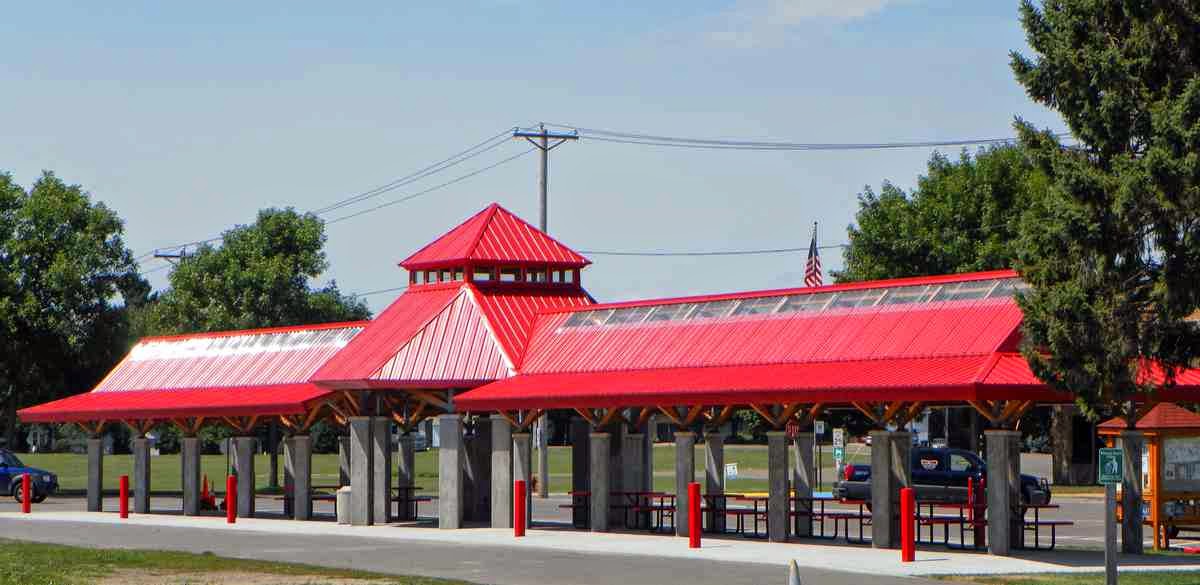
Wisconsin's Cattail State Trail runs for nearly 18 miles on an old Soo Line rail line between Amery and Almena with access in Turtle Lake. A good spot to start the hike is in Amery at the Trailhead Pavilion in Soo Lake Park (below; photo courtesy City of Amery) Parking, restrooms and wifi access is available there.


Heading east from the pavilion, the trail crosses a bridge over the Apple River (below).


The trail is flat and wide as it leaves Amery (below).


The diversity of trees makes for a colorful autumn walk (below; photo courtesy of Wisconsin DNR).


Here's a full description of the trail.

Read more about day hiking this and nearby trails in my Hittin’ the Trail: Day Polk County, Wisconsin guidebook.


Sunday, June 30, 2013

Cabin Coffee Shop in Amery, Wis., hosts meet-the-author event

A special thank you to the Cabin Coffee Shop in Amery, Wis., for hosting my meet-the-author session on Saturday, June 29, 2013. We sold some books, met some great people, and introduced a few others to a great coffee shop. The Amery stop is part of my summer book tour promoting Headin’ to the Cabin: Day Hiking Trails of Northwest Wisconsin, which describes more than a 100 day hiking trails in Ashland, Barron, Bayfield, Burnett, Douglas, Polk, St. Croix, Sawyer and Washburn counties, including several in the Amery area. Missed the Amery stop? No worries. You can meet more than 20 regional authors, including yours truly, at the Northwind Book and Fiber book fair in Spooner, Wis., on Saturday, July 6.

Read more about family friendly day hiking trails in my Headin' to the Cabin guidebooks.


Tuesday, June 25, 2013

Cabin Coffee Shop in Amery, Wis., hosting book reading/signing

The Cabin Coffee Shop in Amery, Wis., is graciously hosting a book reading/signing for my recent book, Headin’ to the Cabin: Day Hiking Trails of Northwest Wisconsin, on Saturday, June 29 from 10 a.m. to noon (An appropriately named place for the reading, isn’t it?). The coffee shop serves breakfast, lunch and great sweet treats. Headin’ to the Cabin describes more than a 100 day hiking trails in Ashland, Barron, Bayfield, Burnett, Douglas, Polk, St. Croix, Sawyer and Washburn counties, including several in the Amery area. The Cabin Coffee Shop is located at 1300 110th St. (just off of U.S. Hwy. 8) in Amery.

Read more about family friendly day hiking trails in my Headin' to the Cabin guidebooks.


Wednesday, June 12, 2013

Polk County (Wis.) Info Center now carrying ‘Headin’ to the Cabin’

The Polk County (Wis.) Information Center is carrying my recent book, Headin’ to the Cabin: Day Hiking Trails of Northwest Wisconsin. The center provides tourism information for visitors to Polk County and Wisconsin in general and includes a gift store featuring books on local topics. Headin’ to the Cabin details more than three-dozen Polk County trails, including those in or near the communities of St. Croix Falls, Osceola, Amery, Frederic, Luck, Turtle Lake and Balsam Lake. The information center is at the intersection of U.S. Hwy. 8 and Wis. Hwy. 35.

Find out about other trail guidebooks available in the Hittin’ the Trail series.


Wednesday, June 5, 2013

Third ‘Hittin’ the Trail’ book, on Polk County, Wisconsin, released

The third book in my Hittin’ the Trail hiking guide series, Hittin’ the Trail: Day Hiking Polk County, Wisconsin, went on sale Tuesday. The ebook lists dozens of great family-friendly trails in all of your favorite Polk County communities, including St. Croix Falls, Osceola, Amery, Turtle Lake, Balsam Lake, Frederic and Luck. Included is a primer about day hiking essentials, such as gear, clothing, navigation, and how to avoid various trail dangers. Day Hiking Polk County, Wisconsin is available as an ebook on Kindle, Nook, iBook/iPad, Kobo, and other formats.

Find out about other trail guidebooks available in the Hittin’ the Trail series.


Wednesday, April 17, 2013

Rail line converted to trail great for hiking

 Stower Seven Lakes State Trail west of Amery.
Stower Seven Lakes State Trail map

Stower Seven Lakes trail
runs thru woods, farms


Peaceful woodland, serene ponds, and picturesque farms await day hikers on the Stower Seven Lakes State Trail heading west of Amery.

Built on a former rail line, the 14-mile trail heads to a mile short of Dresser. A good segment to take is from the trailhead in Amery for about 3 miles to the southern tip of Bear Trap Lake.

With a surface of crushed limestone and the generally level grade of rail lines - to save locomotive fuel consumption, railroads sought grades of no more than 3 percent for their lines - the trail is easy for families with children to handle. Milepost signs conveniently punctuate the trail.

Pastoral scenery
In Amery, the trail begins on Harriman Avenue west of Wis. Hwy. 46. A public parking lot is near the trail just east of Harriman Avenue.

About 0.2 miles in as leaving Amery, the trail crosses between North Twin and South Twin lakes. On North Twin Lake, a popular fishing destination, watch for bald eagles diving to snare walleye or Northern pike for a meal. Loons also can be spotted here.

At just under a mile, the trail crosses Baker Avenue. Though the area is moderately built up, the trail is nicely wooded with maple and oak, keeping you isolated from the sights of modern life.

Around 1.5 miles, the trail skirts a small group of ponds to the north. After that, farmland is visible between the tree breaks to the north and soon becomes more prevalent.

Bear Trap Lake
The trail is named for Harvey and Marilyn Stower of Amery. For many years, Harvey served in the Wisconsin Legislature and as Amery’s mayor.

As nearing Deronda, the trail intersects a couple of highways, so be safe when crossing them. The first of them comes at about 2.5 miles, when the trail junctions with State Highway 115. The next comes at about 2.8 miles with County Road F.

About three miles in, the trail reaches the southern tip of Bear Trap Lake with Kinney Lake to the south. This marks a good spot to turn around.

If time and energy permits, though, continue onward. At Deronda, the trail heads three more miles to Wanderoos, then 5 miles to Nye, and finally 2.5 miles to its end at 90th Avenue near Dresser.

Monday, April 15, 2013

Great hiking trails await near Clear Lake, WI

Apple River from Cattail State Trail.
Visitors to the northwestern Wisconsin village of Clear Lake will find a number of great day hiking trails worth exploring. Among them:
g Cattail State Trail North of town, pick up the state trail that runs between Amery and Almena. Crushed stone covers the route, and the old rail line is smooth with the most gradual of elevation gains.
g Clear Lake-Clayton Trail Eleven miles of old railbed have been converted into a path running between two villages, the trail’s namesakes. The trail passes several lakes as it nears Clayton.
g Clear Lake Village Park – A short trail takes hikers through tall oaks and white-barked birch trees to French Lake. In autumn, an array of colors from the variety of trees in the 260-acre park are impressive.

Read more about family friendly day hiking trails in my Headin' to the Cabin guidebooks.


Tuesday, April 9, 2013

Several great trails await in Amery, Wis.

Walking Trail at York Park.
Visitors to Amery, Wis., this summer will find trails both impressive and quaint. Two major state trails meet in the “City of Lakes” while a couple of local trails offer small jaunts in wooded sections of town. Five great trails to hike in Amery include:
g Amery Regional Medical Center Walking Trail – The local hospital grounds provides a community walking path running along the Apple River. The forested path nicely keeps views of the urban area to a minimum.
g Green Trail – North of the city, a trio of trails at the Balsam Branch Cross Country Ski Trails make their way through woodlands for hiking, skiing and snowshoeing. Try the Green Trail, a 3-mile trail that includes a segment circling a pond with swans.
g Cattail State Trail This route, located on what used to be old railroad tracks, runs for nearly 18 miles on an old Soo Line rail line between Amery and Almena. The Amery end of trail begins in woodland then passes through farmland and prairie.
g Stower Seven Lakes Trail – The 14-mile trail heads west of Amery past seven glacial lakes to just shy of Dresser. In addition to the lakes, you’ll head through maple and oak forests, prairies and picturesque farms.
g York Park Walking Trail – Three miles of graveled trails take hikers through a hardwood forest and past a lakeshore in this 40-acre park. Despite the park’s urban setting, it’s a prime spot to spot a variety of birds, including common loons, bald eagles and osprey.

Learn about trail guidebooks available in the Hittin’ the Trail series.


Sunday, August 12, 2012

Cattail State Trail rambles along old rail line

Cattail State Trail in autumn
Active railroad lines once crisscrossed northwestern Wisconsin’s beautiful countryside, but the advent of highways made many of them obsolete. A number of those old tracks fortunately have been converted to hiking trails so that modern day walkers can enjoy a plethora of scenery from woodlands to rolling pastures.

Among them is the Cattail State Trail, which runs for nearly 18 miles on an old Soo Line rail line between Amery and Almena with access in Turtle Lake. Its location is perfect for a number of cabin-goers in Polk and Barron counties.

To reach the trail, take U.S. Hwy. 8 to any of the above mentioned communities. The trailhead is on Keller Avenue South (Wis. Hwy. 46) near Baker Street West at Soo Lake Park’s trailhead pavilion in Amery, behind the village hall (where you can park) in Turtle Lake, and on Alma Street in Almena.

As a point along the trial, Turtle Lake serves as a great starting point, since you can break the trail into smaller sections by going either toward Amery or Almena. The Turtle Lake access also is a block from Railway Park, which includes a picnic shelter. Head west toward Amery for wetlands and a thick woods, both of which teem with wildlife, including white-tailed deer, otter, mink, fox, eagles, osprey, a couple of hundred bird species, and even black bear. This five-mile section of the trail running to the village of Joel also is open to horses.

If starting in Amery, the trail begins in woodland then passes through farmland and prairie. Beaver Creek runs alongside the trail as closing on Joel.

In Almena, a 16-mile extension heads east to Cameron. Though pretty, this direction generally is not great for hikers, as three miles into the extension is an expansive area popular with ATVers. The extension also closes around mid-October for hunting and then becomes a snowmobile trail in winter.

Crushed stone covers the main trail, and the old rail line is smooth with the most gradual of elevation gains. The trail boasts six bridges. It does cross several roads, however, so be careful at these intersections, especially if with children.

The trail also is open to dogs, which is great for many families. Dogs must be on a leash 8 feet or shorter at all times, however.

Read more about day hiking Barron County in my Hittin’ the Trail: Day Barron County, Wisconsin guidebook.