 |
| The Appalachian Trail crosses Fontana Dam, the largest dam east of the Rocky Mounties. Photo courtesy of Wikipedia. |
 |
| Topo map: Appalachian Trail, Plate 1 |
 |
| Plate 2 |
 |
| Plate 3 |
 |
| Plate 4 |
 |
| Plate 5 |
 |
| Plate 6 |
Trail enters
Great Smoky
Mountains N.P.
at Fontana Dam
Day hikers can walk the famous Appalachian Trail as it crosses the highest dam east of the Rockies on the way to a lookout tower in Great Smoky Mountains National Park.
The Appalachian Trail’s Fontana Dam to Shuckstack Lookout Tower segment runs 8.2-miles round trip. Parts of the segments are very steep and strenuous.
To reach the trail, from Byron City, N.C., head south/east on U.S. Hwy. 19, which becomes U.S. Hwy. 74. Eventually, N.C. Hwy. 28 joins the highway from the south/east. When Hwy. 28 splits to head north/west, exit on it. Upon reaching Fontana Dam Road/Hwy. 1245, turn right/east onto it. Follow the road until it dead ends in a parking lot at the dam.
Go north from the lot to the dam, taking the walkway onto the dam. The Appalachian Trail heads over it, so this is not a spot for anyone afraid of heights.
At 480 feet high, the dam stretches 2,365 feet long. Impounding the Little Tennessee River, the dam holds back water for 30 miles to form Fontana Lake. Construction of the dam began in 1942 with it opening in late 1944.
Up the ridge
Once on the dam’s other side, the trail technically enters the national park. It veers northwest alongside Lakeview Drive W.; the road/trail roughly parallels the Fontana Lake shoreline.
In 0.6 miles from the parking lot near the end of Lakeview Drive W., the Appalachian Trail splits off to the left/west. From there, you begin a steep climb; the split from the road is at 1879 feet elevation, and more than a 2000-foot ascent awaits you over the next 3.5 miles. Most of the elevation gain, though, comes in the first two-thirds of the hike.
The trail essentially runs atop an unnamed ridge sandwiched between two other elevated hillsides – the Shuckstack Ridge to the east and the taller Twentymile Ridge to the west and north.
Though definitely on a narrow dirt path in the wilderness, don’t worry about getting lost. A simple white line blazed on the trees indicates the AT.
In all, seventy miles of the 2,158-mile Appalachian Trail run through the national park. It enters the park from the north at Davenport Gap; Fontana Dam marks the southern entry point. The park’s tower at Clingmans Dome is the trail’s highest point between Maine and Georgia.
You can stay overnight for free off the trail in the park, unless you’re thru-hiking – which the park service defines as starting at least 50 miles outside of the park with plans to go at least 50s mile beyond it; in that case, you’ll need a permit.
Shuckstack Lookout Tower
At 3.6 miles from the trailhead, you’ll reach the steepest portion of trail. Fortunately, it's short.
The unnamed ridge at its top joins Twentymile Ridge. About four miles into the hike, once atop Twentymile, you’ll reach a three-way junction; go right/east onto the spur trail.
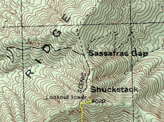
In 0.1 miles, you’ll reach Shuckstack Lookout Tower, which sits at 4020 feet, just above Sassafras Gap. Constructed in 1934, it’s one of three park fire towers still in operation. You can take 78 steps up 60 feet to the top; while generally safe, the steel tower is in need of repair with some steps missing, and the tower's wood floor is partially rotted.
If you do head up to the top, you’ll be rewarded with incredible 360 degrees of the surrounding park. To the west are the Unicoi Mountains. The Great Smoky Mountains rise in the north and east. The Blue Ridge Mountains and Fontana Lake are to the southeast. The ridge you walked on with the Snowbird and Nantahala mountains beyond are to the south.
After taking in the sights, retrace you steps back down the ridge and across the dam to your parking lot.
Learn about other great trails at this national park in Best Sights to See at Great Smoky Mountains National Park.
