Showing posts with label Tennessee. Show all posts

Wednesday, May 11, 2016

Top sights to see at Great Smoky Mtns. NP

One of Great Smoky Mountain National Park's many streams.
Imagine a place where several waterfalls tumble more than eight stories over ancient rock, where you can hike to a mountain vista offering 100-mile views, where countless streams and rivers rush over riffles and cascades through dense verdant forests, where you can traipse through historic pioneer buildings or stand in awe before a rare, majestic elk that haven’t been seen in these parts since George Washington’s time. The place is real. It’s Great Smoky Mountains National Park.

America’s most visited national park, more than 10 million people annually enter the vast, sprawling mountain terrain that crosses the states of Tennessee and North Carolina. The high visitation occurs in part because a sizable number of Americans live within a day’s drive from the park. Great Smoky Mountains’s natural beauty and rich, preserved history, however, ensure it’s a sparkling gem that’s worth the road trip.

Several access points exist for Great Smoky Mountains National Park. Most begin the last leg of their journey to the national park from either Knoxville, Tenn., or Asheville, N.C. For either city, Interstate 40 leads to the park.

From Knoxville, take I-40 east/south. Exit south on Tenn. Hwy. 66, which merges with U.S. Hwy. 441. This runs through Gatlinburg and to the park’s northcentral entrance. Hwy. 441 cuts through the park over Newfound Gap.

From Asheville, go west/north on the interstate. Exit west/south on U.S. Hwy 74 then go west/north on U.S. Hwy 19. In Cherokee, the road junctions with U.S. Hwy. 441, which can be taken north into the park and to Newfound Gap. To reach Bryson City, N.C., and its southcentral entry into the park, continue west on Hwy. 19.

Staying on I-40 from either city takes you to the park’s eastern side. Several popular entrances to the park can be found along the way.

To reach the park’s west side entrances, from Knoxville take U.S. Hwy 129 south. Exiting on N.C. Hwy. 28 heads to Fontana Dam.

Top sights – and the trails to see them at the park – include:
Deep/Indian Creeks
Laurel Falls
Clingmans Dome
Mingus Mill
Elk herd

Learn about other great trails at this national park in Best Sights to See at Great Smoky Mountains National Park.


Saturday, May 7, 2016

Ten must-see sights at Great Smoky N.P.

View from trail on way to Chimney Tops. Courtesy of Photoree.
Great Smoky Mountains National Park is so large that unless you spend years there, you won’t see all it offers. So when you’ve only a week or so to visit the park, what are the absolute must-do sights?

For many park visitors, the narrow Roaring Fork Motor Nature Trail – winding through a dense verdant forest past historic pioneer buildings – is the park. Easy to reach from Gatlinburg, Tenn., on the park’s northcentral side, the one-lane loop offers a variety of outstanding sights, including log cabins, rushing creeks, and wildflowers. Without a doubt, though, the best sight is the national park’s highest waterfall: Rainbow Falls.

In large part because of the strenuous hike, most park visitors eschew Rainbow Falls for one that’s much easier to reach and is quite impressive in its own right: picturesque 80-foot Laurel Falls. It’s unquestionably the national park’s most visited waterfall.

Another of the park’s most scenic drives heads to Cades Cove, an isolated mountain valley that is a popular destination thanks to many well-preserved pioneer buildings. A campground, several historic buildings, and a number of trails heading into the surrounding mountains can be found there. Yet, while incredibly beautiful now, Cades Cove looked quite different to the pioneers who first settled it. That’s because the chestnut – one of the trees that those settlers depended upon – has since largely disappeared. Park visitors can walk through what once a grove of majestic chestnut trees on the Cades Cove Nature Trail.

Newfound Gap Road
The major highway crossing the national park is Newfound Gap Road, which is U.S. Hwy 441, runs nearly 32 miles from south of Gatlinburg to Oconoluftee, N.C. Several waysides allow visitors to hike short distances into the mountain valleys. Among the most impressive sights along the road, however, is the tops of those surrounding peaks. On one of those sights, Chimney Tops, you walk across a rare rock summit and be rewarded with some of the best views around.

The other fantastic mountain top along the Newfound Gap Road is Clingmans Dome, where you can enjoy views of up to a hundred miles atop one of the highest points east of the Mississippi River.

Between Chimney Tops and Clingmans Dome is another outstanding sight along Newfound Gap Road: a pair of cave-like formations with impressive vistas along the way. The 4.4-miles round trip Alum Cave Trail sports an elevation gain of 1120 feet but is well-worth the effort.

Creeks and historic sites
More than 2900 miles of streams and rivers rush down the mountains and across valley floors at the national parks. Because of the streams’ steep grades, they often cut down to erosion-resistant rock, resulting postcard-perfect ribbons of water over riffles. Many drop over ledges to form waterfalls. Among the best ways to enjoy these scenic streams is a combination of the Deep Creek/Indian Creek Falls Trails. Two small waterfalls and a series of small cascades sit in the lark’s south-central section near Bryson City, N.C.

There is no shortage of historic sites to see in the national park. Among the most popular are clusters of them near the Sugarlands Visitor Center southeast of Gatlinburg and those in Cades Cove. One of the less visited but equally impressive sites is the Mingus Historic Grist Mill in the park’s North Carolina section. A 4-miles round trip, the Mingus Creek Trail segment runs past both the historic grist mill and a pioneer cemetery.

Though elk were once a common sight in the southern Appalachian Mountains, over-hunting and habitat destruction doomed them. In fact, North Carolina has not had any native elk since the late 1700s – until reintroduction efforts began in the national park during the early 2000s. Visitors now can see a rare herd of elk on the Big Fork Ridge Trail.

The longest hiking-only footpath in the world – the Appalachian Trail – runs 2158 miles between Maine’s Mount Katahdin and Georgia’s Springer Mountain. In all, seventy miles of the trail heads through Great Smoky Mountains National Park. Most of it is deep in the park’s interior. One very accessible section of the trail in the park can be found where it crosses the highest dam east of the Rockies on the way to a lookout tower. The Appalachian Trail’s Fontana Dam to Shuckstack Lookout Tower segment runs 8.2-miles round trip.

Learn about other great trails at this national park in Best Sights to See at Great Smoky Mountains National Park.


Monday, April 25, 2016

Great Smoky Mtns. abounds with waterfalls

Ramsey Cascades, courtesy Great Smoky Mountains NPS.
Thanks to geography, Great Smoky Mountains National Park is a great destination for waterfall lovers.

All across the park, the steep grade of rivers and creeks has carved down to erosion-resistant layers that suddenly drop-off. A few waterfalls top 90 feet in height.

Most of these can be reached via a day hike. They include:
Ramsey Cascades – Water spills over 100 feet of cascades, a great reward for the strenuous 8-mile round trip hike. Park at the trailhead along Greenbrier Road.
Juney Whank Falls – The 90-foot falls, split into two sections, is easy to reach via the 0.8-mile round trip Juney Whank Falls Trail. Park at the end of Deep Creek Road north of Bryson City, N.C.
Hen Wallow Falls – The Gabes Mountain Trail runs 4.4 miles round trip to the 90-foot falls. Park in the lot designated for hikers at the Cosby Picnic Area.
Rainbow Falls – At 80 feet, this is the park’s highest single-drop waterfalls. Reaching it requires a 5.4-miles round trip hike uphill, but there are several other small falls along the way to enjoy.
Laurel Falls – A picturesque 80-foot waterfall awaits day hikers on the Laurel Falls Trail. The easy-to-reach trail runs 2.6-miles round trip from a lot at Fighting Creek Gap.
Mouse Creek Falls – The 45-foot falls can be reached via the 4-mile round trip Big Creek Trail near Cataloochee, N.C. Park at the Big Creek Trailhead on a gravel road off of Waterville Road.
Grotto Falls – The 25-foot falls awaits at the end of the Trillium Gap Trail, a 3-mile round trip hike through old-growth hemlocks. Park at the trailhead off of the Roaring Fork Motor Nature Trail.
Indian Creek Falls – The falls, which cascades about 25 feet down a series of ledges into a wide pool. The 1.6-mile round trip is located on the Deep Creek/Indian Creek Falls Trail north of Bryson City, N.C.
Abrams Falls – Though a short drop of only 20 feet, the ferocity of the water tumbling over the falls is impressive. The trailhead for Abrams Falls Trail is just past Stop No. 10 on the Cades Cove Loop road.
Mingo Falls – The area’s best falls – at 120 feet the tallest in the southern Appalachians – actually sits just outside of the park on the Cherokee Indian Reservation in North Carolina. Take the Pigeon Creek Trail for 0.4-miles round trip from the Mingo Falls Campground to the falls.

Learn about other great trails at this national park in Best Sights to See at Great Smoky Mountains National Park.


Wednesday, April 13, 2016

Several entries lead to great GSMNP hikes

The view from atop Clingman's Dome.
A vast, sprawling park covering 816 square miles, Great Smoky Mountains National Park offers a number of access points and sections.

Most visitors enter through Gatlinburg, Tenn., which sits at the park’s northcentral side. There’s good reason to select Gatlinburg, as it leads to multiple scenic areas. Among them is the Roaring Fork Motor Trail, which offers trailheads to 80-foot Rainbow Falls and Mount Le Conte. The Sugarlands Visitor Center is west of that road and provides access to pretty Laurel Falls and the Elkmont and Tremont areas.

Gatlinburg also is the main way to reach another popular section of the park – Cades Cove. The cove is in the park’s northwest. Nearby can be found a historic mill and farm site as well as the Cades Cove Nature Trail.

The Newfound Gap Road is the main north-south highway through the park, running from Gatlinburg to the Oconaluftee area. Along the way is Clingman’s Dome (the highest point on the Appalachian Trail), Chimney Tops, the Alum Cave Trail, the Mingus Mill, and the Mountain Farm Museum.

From North Carolina, Bryson City serves as a major entry point to the park’s southcentral section. Footpaths pass several streams with waterfalls, most notably the Deep Creek/Indian Creek Falls Trail.

Some less used access points include Fontana Dam in the park’s southwest side, Hentooga Ridge Road, which runs past Balsam Mountain, Cataloochee, and Big Creek, all in North Carolina. Other Tennessee entries includes Cosby, Greenbrier (south of Pittman Center), and Townsend, which runs to either Cades Cove or Tremont.

Learn about other great trails at this national park in Best Sights to See at Great Smoky Mountains National Park.


Tuesday, April 5, 2016

Great Smoky’s geography means great trails

Spruce Flat Falls, Great Smoky Mountains National Park.
The Great Smoky Mountains’ geography consists of several mountains with valleys tucked between them and the ridgelines leading to their peaks. The result is a number of great, diverse hiking trails to explore.

For many Americans, it is synonymous with the Appalachians though only a small part. Among the oldest mountains in the world, the Appalachians stretch from Alabama northeast to Canada and so are much diverse geographically and culturally. The Southern Appalachians contain two ranges – Blue Ridge, which is to the northeast, and Unakas, which is to the Southwest. The widest part of the Unakas Range is the Great Smoky Mountains.

The Great Smoky Mountains also are almost the Appalachian’s tallest, containing 16 peaks above 5000 feet. The higher elevations receive an average of 85 inches of precipitation annually.

At 6625 feet, Clingmans Dome is the highest point in the national park and anywhere along the 2175-mile Appalachian Trail, as well as the third highest east of the Mississippi River. From its summit on a clear day, hikers can see for more than 100 miles across Tennessee to the north and North Carolina to the south and east. The Clingmans Dome Trail runs 1-mile round trip from the visitor center to the summit, which sports an observation tower on top.

That water drains off the Great Smoky’s peaks in more than 2100 miles of streams and rivers. All of it eventually reaches the Tennessee River, which flows into the Mississippi River.

The waterflow has left an array of beautiful scenery – waterfalls, gurgling streams, deep valleys beneath high rocky peaks, gaps between the mountains where roads and trails run, and more.

Among the park’s prettiest stretches of water is a half-mile run of Big Creek in North Carolina. Take the Big Creek Trail on a 4-mile round trip to where the stream spills between two large boulders to form the Midnight Hole, then a half-mile later come to where Mouse Creek empties into Big Creek via a 35-foot waterfalls.

Because of the elevation changes and the high precipitation, the Great Smoky Mountains holds five distinct ecosystems that support an incredible amount of biological diversity. More than 1500 flowering and 4000 non-flowering plants can be found there. Rare old-growth hemlock trees can be found in several spots, most notably the Alum Cave Trail.

The highest single-drop waterfall in the national park is Rainbow Falls at 80 feet. The Rainbow Falls Trail runs 5.4-miles round trip to the sight.

Learn about other great trails at this national park in Best Sights to See at Great Smoky Mountains National Park.


Monday, March 28, 2016

Trails explore Great Smoky NP’s rich history

John Oliver cabin, built in 1822-23 at Cades Coves, Great Smoky Mountains
National Park. Courtesy of By I, Bms4880, CC BY 2.5 /Wikipedia Commons.

Pioneer cabins, mills await on short day hikes


A number of great day hikes allow visitors to explore the Great Smoky Mountain National Park’s rich history.

The area that now makes up Great Smoky Mountains National Park has been long inhabited by Native Americans. One projectile found in the park dates to 9000 years ago.

When white settlers arrived in the late 1700s, Cherokees were the dominant tribe. They called the Great Smoky Mountains Shaconaqu or “place of blue smoke.”

As homesteaders settled the Great Smoky Mountains, the Cherokees viewed them as encroachers; after violence erupted, the Army intervention ensued. Following the Treaties of 1798 and 1819, Cherokees were forced to give up the mountains.

Then in 1838, the Army forcibly captured and moved Cherokees who refused to leave the Great Smokies. An estimated 4000 Cherokees died on the Trail of Tears in the relocation to Oklahoma. Still, some legally remained and became the Eastern Band of Cherokees.

Pioneers
White settlers of the Great Smoky Mountains mostly were of Scotch-Irish, English and German descent. Oconaluftee and Cades Cove were the first communities established. The John Cable Mill Trail allows visitors to see several historic buildings at Cades Cove.

Before electricity, people depended upon water wheels to power grist mills. The Mingus Mill, built in 1886, still stands today and can be seen via the Mingus Creek Trail, which heads along its namesake in North Carolina. When done hiking, drive a half-mile south of the trailhead to the Mountain Farm Museum and explore a farmhouse, barn, applehouse, springhouse, and smokehouse also all built in the 19th century.

Lumber companies followed in the late 1800s – some areas communities such as Smokemont, Tremont, Ellmont and Proctor initially were company towns – and they found great riches to be had. Some trees were so large that a single trunk filled a railcar.

Clearcutting left erosion and wildfires in its wake, however. As the primeval forest disappeared, a movement to preserve it arose. In 1923, businessman Willis Davis and wife Anne, who served in the Tennessee Legislature, proposed that the area be preserved as a national park. Congress authorized creation of the park three years later.

To actually have a national park, though, required the monumental task of purchasing 6000 separate tracts of land that would comprise the park. The effort quickly began in earnest during the 1920s.

Modern park
By the 1930s on the sections of land purchased and preserved as a national park, the Civilian Conservation Corps constructed trails, fire towers, and other infrastructure. The Appalachian Trail later was built through the park on its way between Maine and Georgia.

One of the great ecological disasters in the park occurred during the first-half of the 20th century when blight, due to a fungus accidentally introduced from Asia, quickly wiped out whole groves of chestnuts. By the 1940s, the blight had destroyed about 4 billion trees nationwide. The Cades Cove Nature Trail heads through an area in which chestnut trees once towered.

The park received a boost in public interest during the 1950s when Disney filmed parts of its popular television series “Davy Crockett, King of the Wild Frontier” there.

During the early 2000s, park officials reintroduced a herd of elk to the park. Native elk had not graced the park since the late 1700s when overhunting and habitat loss doomed them in the Great Smoky Mountains. Today, the elk can be see at the trailhead for the Big Fork Ridge Trail.

Learn about other great trails at this national park in Best Sights to See at Great Smoky Mountains National Park.


Sunday, March 20, 2016

Explore Great Smoky Mountains’ geology

The highest points of the Great Smoky Mountains consist of
erosion-resistant metasandstone.
One billion years ago, the area that now is the Great Smoky Mountains sat in an ocean at the edge of the North American continent. As clay, mud, sand and silt eroded off a nearby highlands, they filled the water, forming a layer nine-miles thick.

Much of the rock currently at the national park’s surface are sedimentary layers that piled atop that layer over a span of 95 million years beginning about 545 million years ago. Fossils of sea creatures – burrows of worms and shells of crustaceans – can be found in these sedimentary layers at the park, most notably Cades Cove.

About 310 million years ago, the North American and African tectonic plates crashed into one another. For the next 65 million years, this grinding of plates pushed up land all along the North American coastline, creating the Appalachian Mountains, which stretched from Newfoundland to Alabama. At one time, the Appalachians stood as high as the Rocky Mountains do today.

As the two tectonic plates separated and moved to their current positions, erosion began to tear down the Appalachians. Rivers and streams moved the sand and silt to the Atlantic Ocean and Gulf of Mexico; in fact, some of today’s Gulf of Mexico beaches are made of eroded rock from what is now the Great Smoky Mountains.

The most resistant of those rocks – metasandstone – remain the park’s highest peaks. The majority of waterfalls occur at metasandstone ledges.

In the millennia ahead, the Great Smoky Mountains eventually will erode away. Geologists estimate the park is losing about an inch of elevation every 500 years.

Some great spots to explore the park’s geology include:
Chimney Tops Trail
Clingmans Dome Trail
Rainbow Falls Trail

Learn about other great trails at this national park in Best Sights to See at Great Smoky Mountains National Park.


Saturday, March 12, 2016

Kid activities abound at GSM National Park

Courtesy Great Smoky Mountains NPS.
A trip to Great Smoky Mountains National Park can be an educational experience for kids – though they may be having too much fun to even notice that they’re learning!

The park delivers a variety of great activities that children can participate in from spring through autumn. Among the many offerings:
Ranger-led events – Programs at several locations throughout the park focus on a range of interests, from wildlife and plants found in the Great Smoky Mountains to preserving local natural and cultural treasures. Among the most popular programs are the daily milling demonstrations at historic Mingus Mill and Cable Mill.
Junior Ranger Kids – Kids between the ages of 5-12 can become a Junior Ranger. They’ll first need to purchase a Junior Ranger booklet (available online, at any park visitor center or at the Cades Cove or Elkmont campground) and complete its activities, and then they can receive a Junior Ranger badge. A Not-So-Junior Ranger program is available for teenagers (and adults who still fancy themselves kids).
Summer camps and workshops – Family camps, naturalist workshops, summer camps, hikes, and other adventures are available in the park at the Great Smoky Mountains Institute at Tremont and the Smoky Mountain Field School. Most require advanced registration.

Learn about other great trails at this national park in Best Sights to See at Great Smoky Mountains National Park.


Saturday, February 13, 2016

Great Smoky trail heads to ‘caves,’ views

View from Alum Cave. Photo courtesy of Wikipedia.
Topo map of Alum Cave Trail.

Popular Alum Cave Trail
refurbished during 2015


A pair of cave-like formations and fantastic vistas await day hikers on the Alum Cave Trail in Great Smoky Mountains National Park.

The 4.4-miles round trip sports an elevation gain of 1120 feet but is well-worth the effort. In fact, the trail is so popular during autumn and on any weekend with pleasant weather, that you’ll want to arrive early or you won’t find a parking space.

To reach the trailhead, from Gatlinburg, Tenn., drive south on Newfound Gap Road/U.S. Hwy. 441 for about 10 miles; look for parking lot on left/east for the Alum Cave Trailhead. The dirt-packed trail starts at 3830 feet elevation in the Grassy Patch and immediately crosses Walker Camp Prong.

For the next mile, the trail heads through an old-growth forest of hemlock and yellow birch alongside Alum Cave Creek. The grade is gentle.

It then turns north and follows the Styx Branch, a tributary of Alum Cave Creek. During summer, rhododendron blooms here, making for an impressive sight.

Arch Rock
At 1.3 miles, the trail reaches the first cave-like formation, Arch Rock. Freezing and thawing created the arch by eroding away the softer rock beneath the harder black slate. The trail goes under the arch, and steel cables sometimes serve as handrails. Hikers take stone steps out of Arch Rock.

From there, the trail crosses the Styx Branch and becomes fairly steep.

At 1.9 miles, the trail reaches Inspiration Point, an outcropping at 4700 feet elevation. It offers great views. To the west is Little Duck Hawk Ridge; the Eye of the Needle, a hole in the rock at the ridge's top, can be seen from here as well. To the northeast is Mount Le Conte, the sixth highest peak east of the Mississippi River.

Peregrine falcons – locally called duck hawks – can be spotted flying about in the area. In fact, the trail’s destination sits just below the aptly named Peregrine Peak.

Alum Cave
At 2.2 miles, the trail arrives at Alum Cave. Not truly a cave but a bluff of orange clay with a concave wall that stretches 80 feet high and close to 500 feet long, it technically is known as a rock shelter. Water often drips off the black slate ledges above, and during winter, icicles will form and drop, making this a dangerous stop during the colder months.

The cave takes its name from the alum that was mined there during the mid-1800s. A company dug out Epsom salt from the cave as early as 1838; this was used as a reddish brown dye for clothing. The Confederate Army in the 1860s mined saltpeter from the cave to manufacture gunpowder.

Sitting at 4950 feet elevation, the cave offers excellent views of the surrounding countryside. The trail can be taken all the way to the summit of Mount Le Conte (even better vistas are to be had on the climb up), but for a day hike the cave makes a good spot to turn back.

Other trail reports often claim the route can be muddy and with tree roots difficult to walk. While those reports are accurate, in 2015 the trail got a much needed makeover, repairing sections where erosion and landslides had caused damage.

Learn about other great trails at this national park in Best Sights to See at Great Smoky Mountains National Park.


Friday, February 5, 2016

Trail heads through former chestnut grove

Gold autumn leaves of a rare chestnut tree
in Great Smokey Mountains National Park.
Photo courtesy of GSMNPS.

Short path crisscrosses isolated
valley at Great Smoky Mountains


Day hikers can walk through what once a grove of majestic chestnut trees in Great Smoky Mountains National Park via the Cades Cove Nature Trail.

The 1.4-miles round trip trail (from the parking lot) sits in Cades Cove, an isolated mountain valley that is a popular destination thanks to many well-preserved structures from pioneer days. The chestnut was one of the trees that those settlers depended upon.

To reach the trailhead, from the park’s Townsend Entrance Road in Tennessee, go right/west on Laurel Creek Road. The scenic highway heads straight into Cades Cove. Once there, go left/south into the Cades Cove Campground and park at the ranger station.

Topo map, Cades Cove Nature Trail.
From the lot’s southwest corner, walk south alongside Campground Drive. The road curves east. As it begins to curl north, look for the Cades Cove Nature Trail trailhead on the right/east.

A short stem trail leads to the main loop. Where the loop begins, continue straight/southeast. The loop is about a half-mile.

Saplings and overlook
In the 1800s, the mountainsides of Cades Cove looked dramatically different than today. At that time, nearly a third of the forest surrounding Cades Cove consisted of towering chestnut trees. During spring, the chestnut blossoms made the mountainsides appear as if they were covered in snow. Each autumn, settlers could stand knee-deep in chestnuts. Many of the trees had diameters of nine to ten feet.

As the trail comes to Cooper Branch, which it crosses four times, there are no chestnuts to be seen. These days, oak, dogwood, sourwood and pine dominate.

What killed the chestnuts? Blight, via a fungus accidentally introduced from Asia, quickly wiped them out. By the 1940s, the blight had killed about 4 billion trees nationwide.

After the last crossing, the trail winds away from the creek to an overlook about 60 feet above the creek. Look along the way for spindly chestnut saplings, all that remain of the once mighty groves.

Significant changes
The loss of the chestnuts greatly changed life in the valley. Lumber from the tree, which was considered straight-grained and durable, no longer could be sold. Many settlers also had incorporated the sweet chestnut into their diets and gathered them for sale in nearby urban markets.

Animals suffered as well from the collapse of the chestnut groves. The fall nuts were a source of high calories for bears. They now rely on the less nutritious acorn for food.

From the overlook, the trail winds down the small hill then rejoins the stem. From there, retrace your steps back to the parking lot.

Despite the loss of the chestnut tree, the trail is still beautiful. Dogwoods bloom in spring while the sourwoods and maples turn red in autumn.

Note that older maps and literature refer to this route as the Vista Trail.

Learn about other great trails at this national park in Best Sights to See at Great Smoky Mountains National Park.


Thursday, January 28, 2016

Paved trail heads to high, scenic waterfalls

Laurel Falls, Great Smoky Mountains National Park, courtesy Wikipedia.
Topo map, Laurel Fall Trail.

Popular route sits in northcentral Great Smoky Mountains NP


A picturesque 80-foot waterfall awaits day hikers on the Laurel Falls Trail at Great Smoky Mountains National Park.

The easy-to-reach trail runs 2.6-miles round trip but gains 314 feet in elevation. During peak season, get to the trailhead early as the parking lot for the popular trail quickly fills up. For great photos, hike early morning or late in the day, as the shade from the nearby mountains will prevent the water in your pictures from being washed out as reflecting sunlight.

Mountain laurel
To reach the trailhead, from Gatlinburg, Tenn., take U.S. Hwy 441/Newfound Gap Road south. Turn left/west onto Fighting Creek Gap Road. Upon reaching Fighting Creek Gap, watch for a parking lot on right/north side. The trail leaves from the center of the lot's north side.

One of the reasons this trail remains popular is that the section leading to the impressive waterfalls is paved. Built during 1932 so fire crews could quickly reach the Cove Mountain area if needed, erosion quickly became a problem, and the trail was paved. Still, due to the steep grade and rough pavement, it’s not suitable for strollers or wheelchairs.

The trail heads through a pine-oak woods with hemlock and beech along the stream, making for a colorful walk in autumn. May also is impressive, as mountain laurel blooms along the trail and near the falls, which runs its highest that month.

Within short order, the trail crosses Pine Knot Branch then begins to parallel Laurel Branch. Wooden posts appear every 0.1 miles so that you know far you’ve come.

Laurel Falls
Deer, often with fawns, wood squirrels, and songbirds are common on the trail. Be aware that black bears do live in the area and sometimes can be seen from the walkway; don't litter – including tossing apple cores – along the trail, as this attracts the bears.

The waterfall on Laurel Branch is magnificent, consisting of an upper and a lower section. A wide walkway crosses the stream where the mist from the falls roils over her head.

Stay off the rocks near the falls, as they are slippery due to mist and algae. In addition, the trail sports steep drop-offs, especially close to the falls, so keep an eye on children.

For those with a little extra energy, the trail continues past the waterfall to an old fire tower on Cove Mountain's summit. The tower is 4-miles round trip from the parking lot.

Learn about other great trails at this national park in Best Sights to See at Great Smoky Mountains National Park.


Wednesday, January 20, 2016

Hike to Great Smoky’s ‘highest’ waterfall

Rainbow Falls. Photo courtesy of Great Smoky Mountains NPS.
Topo map for Rainbow Falls Trail, Plate 1
Topo map for Rainbow Falls Trail, Plate 2
Topo map for Rainbow Falls Trail, Plate 3

Rainbow Falls drops 80 feet near Gatlinburg, Tenn.


Families can hike to Great Smoky Mountains National Park’s highest waterfall on the Rainbow Falls Trail in Tennessee.

The 5.4-miles round trip does come with an asterisk – there are several other falls in the park that are taller, but Rainbow is the highest single-drop waterfall. To see it, you must traverse a 1500-foot gain in elevation, which is enough that temperatures will vary a few degrees between the parking lot and the falls.

To reach the trail, from U.S. Hwy. 441 in Gatlinburg, drive south on Historic Nature Trail, which becomes Cherokee Orchard Road as entering the park. These are segments of a set of roads that form the famous Roaring Fork Motor Nature Trail. After a couple of miles in the park, the road loops; once on that, look for Rainbow Falls parking lot signs.

Le Conte Creek
The trail leaves from the lot's southwest corner at about 2575 feet elevation. It heads through an old-growth forest and in short order crosses the Trillium Gap Trail.

From there, the trail curves south over a boulder-strewn path and then parallels Le Conte Creek. Portions of trail here are rocky, so be sure to wear a good pair of hiking boots and bring trekking poles.

The trail crosses the creek a few times, as well as two tributaries. The gurgle of a number of cascades on the creek fill the air, and along the way you’ll be sure to find some great spots to picnic.

Most of the cascades are due to the creek flowing down a steep grade. The trail actually is heading up a side of Mount Le Conte, the park's third highest peak. The ridge on the creek's north side is the mountain's Rocky Spur.

Rainbow Falls
At last, the trail arrives at Rainbow Falls, which makes an 80-foot drop. The falls’ lip sits at 4326 feet elevation, and a footbridge crosses the creek below the falls.

Spring marks the best time to see the falls, as the water flow will be the greatest. Mount Le Conte receives about eight feet of rain per year. It’s also worth waiting for a sunny afternoon to make the trek, as a rainbow then forms in the mist, giving the trail its name.

Winter can offer its own delights, though, as ice formations sometimes build up around the falls during cold spells.

As tempting as it may be, stay off the rocks near the waterfalls. They are slick from the mist and algae, and over the years several people have fallen off them to their deaths.

Turn back at the waterfalls. If you have some extra energy, you can continue on to Mount Le Conte, however, for an additional 8-miles round trip and a significant ascent.

Final tip: If you bring a camera with you to catch a picture of the falls, leave early in the morning. The sun’s position in the late morning and early afternoon will adversely effect the photo, and a number of other hikers are likely to get into your shot.

Learn about other great trails at this national park in Best Sights to See at Great Smoky Mountains National Park.


Sunday, September 6, 2015

Day hike to summit with 100-mile views

Observation tower atop Clingmans Dome at Great Smoky National Park.
Topo map of Clingmans Dome Trail.

Paved trail heads
to summit of
Clingmans Dome


Day hikers can enjoy views of up to a hundred miles atop one of the highest points east of the Mississippi River.

The 1-mile round trip Clingmans Dome Trail heads to the highest spot in Great Smoky Mountains National Park and Tennessee and the third tallest east of the Mississippi. At 6625 feet, Clingmans Dome also is the highest point along the 2175-mile Appalachian Trail.

360 degree views
The road to Clingmans Done typically is open only from April through November. Autumn leaves usually change about mid-October, offering a spectacular red, orange and yellow display, but be aware that at this high elevation snow can fall as early as September.

To reach the trailhead, from the Newfound Gap Road, just 0.1 miles south of Newfound Gap, turn on to Clingmans Dome Road. Scenic pullouts with impressive views of ridges and valleys line the 7-mile highway. At the road’s end is a large parking area for the trail, which begins at the visitor center.

The paved but steep 0.5-mile trail heads to a 54-foot observation tower at the summit. The elevated trail and the tower itself has a space-age feel with its curved paths and flying saucer-like observation platform.

Still, the top rewards with fantastic 360 degree views. On clear days, 100-mile views are possible. Tennessee is to the north and west while North Carolina is to the south and east. A verdant spruce-fir forest sits at the ridge tops while in autumn the leaves of hardwoods below adds swaths of harvest colors.

Changing view
Unfortunately, a couple of obstructions can limit the views. A natural barrier is clouds. Due to the high elevation, precipitation at the summit is common.

The man-made barrier is air pollution. It can limit views to less than 20 miles. Due to air currents, pollution from vehicles, factories and other sources sometimes flow above the Great Smoky Mountains.

The view from Clingmans Dome is likely to change in the decades ahead. The invasive balsam woolly adelgid threatens stands of Fraser fir, which used to be the dominant tree at the park’s highest elevations. Meanwhile, the hemlock woolly adelgid is wiping out hemlock trees across the park; the latter bug’s devastating effects can be seen along Newfound Gap Road. In just a few decades, the existing forest will be replaced by younger trees of other species with a number of open areas where berry plants thrive.

Besides the disappearing view, two more good reasons to hike Clingmans Dome are the fantastic sunrises and sunsets. The latter time can be crowded, though, as those hoping to photograph the stunning scenery often line up for some 45 minutes before the sun sets.

Final notes: While the trail is paved, it is too steep for wheelchairs. Pets and bicycles are not allowed on the trail. Temperatures at Clingmans Dome usually are at least 10 F and sometimes 20 F cooler than the lowlands, so be sure to bring a sweatshirt or jacket.

Bonus trivia: The two highest points east of the Mississippi River are about 70 miles away, as the crown flies, in North Carolina’s Mt. Mitchell State Park. They are Mt. Mitchell (6,684 feet) and Mt. Craig (6,647).

Learn about other great trails at this national park in Best Sights to See at Great Smoky Mountains National Park.


Friday, May 29, 2015

Steep hike heads up to rare rock summit

Lower of the Chimney Tops' twin peaks, seen from the higher summit.
Photo courtesy of  Great Smoky Mountains NPS.
Topo map, Chimney Tops Trail.

Chimney Tops
Trail popular route
in Great Smoky


NOTE: Due to recent wildfires, the Chimney Tops Trail remains closed as of April 2017.

Day hikers can ascend to a rare rock summit in Great Smoky Mountains National Park and be rewarded with some of the best views around via the Chimney Tops Trail.

The 2-mile one-way trail includes a steep 1700-foot gain in elevation. The good news is that in December 2014 the National Park Service completed a major refurbishing of the trail that included adding 367 rock steps – each weighing 300 pounds – and 291 locust log steps – most of them weighing about 80 pounds – which ensure a stable route.

To reach the trailhead, from Gatlinburg, Tenn., take the Newfound Gap Road (aka U.S. Hwy. 441) south into the national park. Signs point to the Chimney Tops parking lot, which is more of a pullout; note that the trailhead’s parking lot actually is a few miles south of the Chimney Tops campground.

Stream valley
The hike begins on the lot’s northwest side, immediately entering the lush woodland at about 3490 feet elevation. In quick order, the dirt trail crosses the West Little Prong Pigeon River, whose boulders send the water churning and cascading. It then crosses the Road Prong, a small stream that flows into the aforementioned river.

For a while, the trail loosely parallels the Road Prong before crossing it again to the stream’s flatter and broader east side. After making one more crossing, at 0.9 miles, the Road Prong Trail intersects with the Chimney Tops Trail. Go right/north to stay on your trail.

• Locate this trail in Great Smoky Mountains National Park

From there, the trail ascends nonstop. In just half a mile, you’ll reach 4400 feet elevation.

The home stretch sometimes feels like more of a rock climb than a hike as the trail crosses open stone. The rocks were folded upward about 310 million years ago when the North American and African plates collided, a geological event that formed the entire Appalachian Mountain range. Since then, natural weathering has eroded the top soil and exposed the hard slate, phyllite and metasiltstone.

Grand vista
The Chimney Tops consist of twin peaks. The trail reaches the higher of the pair first. At a little over 4724 feet elevation, the views are impressive to say the least.

To the north is the river valley where you parked your vehicle with Balsam Point towering beyond at 5818 feet. The Sugarland Mountain massif (which the Chimney Tops are part of) rises in the west and south. To the southeast is Mt. Mingus at 5802 feet, and to the northeast is Peregrine Peak at 5375 feet. Directly north of Peregrine Peak and almost straight east from Balsam Point are the highest points in the region, the triple summits of Mount La Conte, the tallest of which is the easternmost at 6593 feet.

Chimney Tops’ second peak, only about 20 feet lower than the first, also offers great views, but the real exhilaration is reaching it by heading over the narrow rocks with the steep drops on either side.

Returning down the mountain to the parking lot can be tough. You may need to scoot down some of the rocks on your butt.

The hike can be difficult for younger children, who will find the steep climb taxing and likely will need to be carried at least part of the way. Teenagers, however, are capable of handling the hike and will find reaching the top a confidence-builder.

Learn about other great trails at this national park in Best Sights to See at Great Smoky Mountains National Park.

Wednesday, October 1, 2014

Best trails for seeing Great Smoky Mountains National Park’s wonders

Mingus Mill. Photo courtesy of Great Smoky Mountains NPS.
Click for interactive map to find trailheads.
Among the best ways to see Great Smoky Mountains National Park’s top sights is via a day hike. Just five short trails will allow you to enjoy each of the park’s highlights – the third highest point this side of the Mississippi, a historic water mill from the 1800s, the tallest concrete dam east of the Rockies, a rare herd of elk, and a scenic waterfalls.

Clingmans Dome
At 6625 feet, Clingmans Dome is the highest point in the national park and anywhere along the 2175-mile Appalachian Trail, as well as the third highest east of the Mississippi River. From its summit on a clear day, hikers can see for more than 100 miles across Tennessee to the north and North Carolina to the south and east. The Clingmans Dome Trail runs 1-mile round trip from the visitor center to the summit, which sports an observation tower on top.

Historic Mingus Mill
Before electricity, people depended upon water wheels to power grist mills. The Mingus Mill, built in 1886, still stands today and can be seen via the Mingus Creek Trail, which heads along its namesake in North Carolina. When done hiking, drive a half-mile south of the trailhead to the Mountain Farm Museum and explore a farmhouse, barn, applehouse, springhouse, and smokehouse also all built in the 19th century.

Fontana Dam
Built only a few decades later than the mill, Fontana Dam rises 480 feet high to impound the Little Tennessee River and ranks as the tallest concrete dam this side of the Rocky Mountains. The Appalachian Trail enters the park near the North Carolina dam. Leave your vehicle in the parking lots for the Fontana Village Resort Marina off of Fontana Dam Road (north of Fontana Road) and walk a segment of the AT north to the dam, for a 3.75-miles round trip.

Elk herd
At one time, elk were common in the southern Appalachian Mountains but were overhunted with the last one killed during the late 1700s. More than two centuries later, 26 elk were transplanted in the national park’s picturesque Cataloochee Valley; today, there are more than 140 in the herd. To see them, bring a binoculars and hike the Big Fork Ridge Trail 1.8 miles (3.6-miles round trip) to its summit, which rises 810 feet above a valley the herd often grazes.

Midnight Hole and Mouse Creek Falls
Among the park’s prettiest stretches of water is a half-mile run of Big Creek in North Carolina. Take the Big Creek Trail on a 4-mile round trip to where the stream spills between two large boulders to form the Midnight Hole, then a half-mile later come to where Mouse Creek empties into Big Creek via a 35-foot waterfalls.

Learn more about national park day hiking trails in my Best Sights to See at America’s National Parks guidebook.


Sunday, March 24, 2013

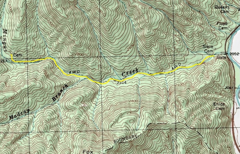
Day hiking trail maps for Great Smoky Mts.

No one ever should hit the trail without a topo map. Here are topo maps for three day hikes in Great Smoky Mountains National Park.

Trails are marked in yellow on the maps. Click each map or open it a new window for a larger, printable version.

National park road map (map courtesy of NPS):

Chimney Tops Trail near Gatlinburg, Tenn.:

Mingus Creek Trail segment near Blue Ridge Parkway:

Rainbow Falls Trail opening segment, Gatlinburg:

Rainbow Falls Trail middle segment:

Rainbow Falls Trail waterfalls segment:

Learn about other great national park day hiking trails in my Best Sights to See at America’s National Parks guidebook.