Showing posts with label Lake County. Show all posts

Tuesday, September 3, 2019

Vista offers 30-mile views of autumn colors

Autumn colors spread across the forest around Skibo Vista Overlook.
Skibo Vista Overlook map.
Day trippers can enjoy sweeping 30-mile views of autumn colors at Minnesota’s Skibo Vista Overlook.

Located on Iron Range, the overlook is an easy stroll, consisting of a mere 250 feet of sidewalk. It is located along the 78-mile Superior National Forest Scenic Byway, which connects the Iron Range to the North Shore.

To reach the overlook, from Hoyt Lakes take Lake County 15 (aka Skibo Outlook Road, Forest Route 110 and Forest Route 128) south. After passing Lake County 129, the lookout is on the left/east.

Located 20 stories above the terrain below, the overlook sits on the Laurentian Divide. One of the continent’s great watershed divides, water on the north side of the Laurentian makes its way toward Hudson Bay while that to the south heads either to the Gulf of Mexico or the Atlantic Ocean. The divide stretches from Triple Divide Peak in northwestern Montana, cuts through Minnesota’s Iron Range, and ends on the Labrador Peninsula at the 60th parallel.

Glacier-shaped terrain
Surrounding the overlook are the Toimi Drumlins. Formed during the last Ice Age, viewed from above the drumlin field looks somewhat like a basket of eggs. Drumlins are a series of elongated, teardropped-shaped hills. Around Skibo Vista, each drumlin ridge is about a mile long, a quarter-mile wide, and 30-50 feet high.

Exactly how the drumlins formed is debated among geologists, but all agree that they were shaped by the glacier’s direction – the ridge’s tapered end points the way the glacier was flowing. Here the drumlins run in a southwest-northeast direction.

Quaking aspen dominates the drumlins’ tops. Their flat leaves easily flutter in the wind, in autumn giving the appearance of moving yellow seas below the overlook. Surrounding them is evergreen balsam fir.

In the distance to the west and southwest are tamarack lowlands. Tamarack is among 20 species of trees in the world that are “deciduous conifers,” meaning they grow cones and sprout needles like conifers but each autumn their needles change colors and fall, just as deciduous trees lose their leaves. Each September, the tall tamaracks – they usually grow between 33-66 high with a trunk two feet in diameter – turn a brilliant gold.

Changes
Mixed amid the aspens and tamaracks are pockets of hardwood forests. Sugar maple, basswood, American elm, and oak populate these enclaves, offering hues of orange, red, yellow and brown.

On a clear fall day, it’s quite a view, with multiple Iron Range towns nestled amid the harvest colors. Soaring eagles and migrating hawks often can be spotted overhead.

Not surprisingly, an observation tower for the Superior National Forest used to stand at the overlook, as it’s a perfect spot to watch for forest fires. A concrete foundation is all that remains of the tower.

Collectively called the Laurentian Mixed Forest, the view didn’t look like this during Minnesota’s early days as a state. When this was Native American land Euro-American settlers arrived, this area was much more like the boreal forests to the north. Red and white pine dominated, with aspen, paper birch, spruce, and balsam fir finding niches. After the pine was cut, aspen and paper birch took over. More change likely is to come in the decades ahead, as global warming allows the the hardwood forest pockets to gain a foothold.


Monday, July 11, 2016

Great trails found in Split Rock state park stretch of Minnesota's beautiful North Shore

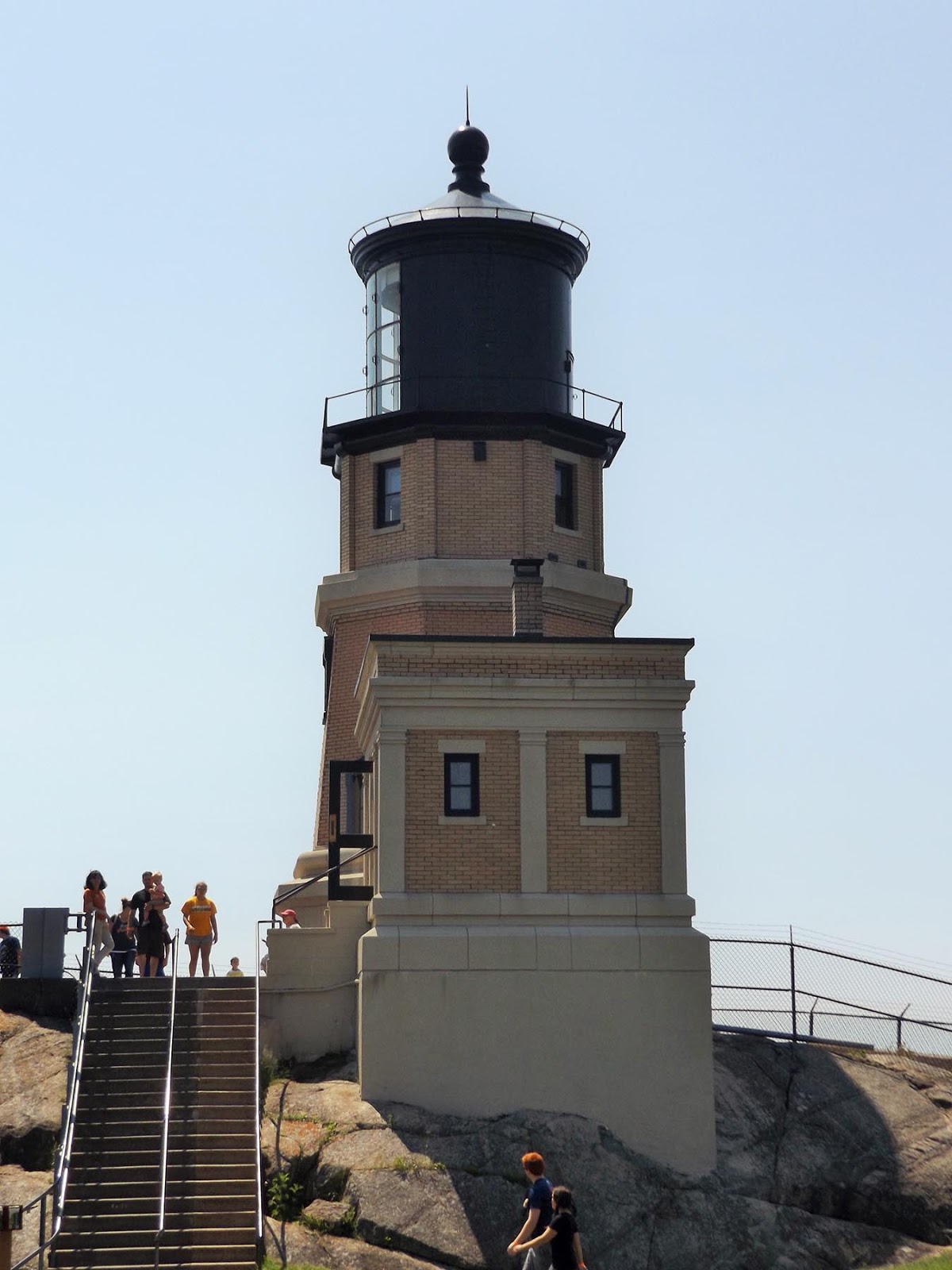
Split Rock Lighthouse, see from the Little Two
Harbors Trail.
With Split Rock Lighthouse State Park tucked between Lake Superior and the high bluffs overlooking the Great Lake, the majority of day hiking trails follow the narrow strip that Minn. Hwy. 61 slices through. The land jutting into the lake and the Superior Hiking Trail traversing the bluffs and valleys cutting into them offer plenty of diverse hiking opportunities, from beaches and vistas to small waterfalls and placid rivers. The best way to locate the trails is to think of how they can be reached from Hwy. 61 as either heading northeast from Gooseberry Falls State Park or southwest from Tettegouche State Park.

Three great hiking trails between Gooseberry Falls and Split Rock state parks include:
Gitchi-Gami State Trail – Twin Points segments
Iona’s Beach Trail
Superior Hiking Trail, Blueberry Hill Road to Split Rock River Valley segment

Three fascinating day hikes in Split Rock state park are:
Split Rock River Trail
Little Two Harbors Trail
Split Rock Lightstation Trail

Three solid hiking trails between Split and Tettegouche state parks include:
Superior Hiking Trail, Beaver Bay to Cove Point segment
Gitchi-Gami Trail, Split Rock to Silver Bay segments
Palisade Head Trail

Learn about nearby hiking trails in Day Hiking Trails of Split Rock Lighthouse State Park.


Monday, July 4, 2016

Photo album of Split Rock day hiking trails

Photo album of Split Rock Lighthouse State Park trails Located along Minnesota’s North Shore a little more than 45 miles northeast of Duluth, Split Rock state park is an outdoor recreational paradise, as well as a site of historical importance. Among Minnesota’s most visited state parks, it’s popular with hikers, campers and nature lovers of all stripes, garnering about 340,000 annual visitors.

Here are some photos of great day hiking trails you’ll find in Split Rock Lighthouse State Park:


Split Rock River Trail
A red rock gorge with waterfalls awaits day hikers on the Split Rock River Trail. The 4.4-miles round trip trail, due to the great scenery and ease of access, ranks also among the Superior Hiking Trail’s most popular segments.


Gitchi-Gami State Trail
Day hikers can get a good sense of what Split Rock Lighthouse State Park is all about via the Gitchi-Gami State Trail, the only route that runs from one end of the park to the other. Though primarily a bicycle trail, the paved Gitchi-Gami can be walked as well.


Little Two Harbors Trail
Great views of a famous lighthouse and of Lake Superior from a pebble beach await on the Little Two Harbors Trail. The 3.2-mile round trip trail ranks among the most popular at the state park.


Split Rock Lightstation Trail
Day hikers can explore one of the nation’s most famous lighthouses and enjoy impressive cliff top views of Lake Superior on the Split Rock Light Station Trail. The 0.8-mile trail is a collection of walking paths around the historic Split Rock lighthouse. Perched atop a 130-foot high solid rock cliff overlooking Lake Superior, Split Rock is among the most photographed lighthouses in the country.

Learn about nearby hiking trails in Day Hiking Trails of Split Rock Lighthouse State Park.


Monday, June 27, 2016

Great sets of day trails await at Split Rock Lighthouse park's southern, northern ends

Split Rock Lighthouse
Located along Minnesota’s North Shore a little more than 45 miles northeast of Duluth, Split Rock state park is an outdoor recreational paradise, as well as a site of historical importance. Among Minnesota’s most visited state parks, it’s popular with hikers, campers and nature lovers of all stripes, garnering about 340,000 annual visitors.

Several major highways offer access to Split Rock. Most converge in Duluth, and from there, it’s roughly 25 miles north via Minn. Hwy. 61 to Two Harbors and then another 20 miles north to the state park.

From the Minneapolis-St. Paul area, take Interstate 35 to Duluth. When I-35 ends, the road becomes Hwy. 61. If in northern Minnesota, take either U.S. Hwy. 2 or U.S. Hwy 53 to Duluth. If in northern or eastern Wisconsin, U.S. Hwys. 45 and 51 as well as Wis. Hwy. 13 all lead to Hwy. 2, which travels west to Duluth. From western Wisconsin, U.S. Hwy. 63 as well as Wis. Hwy. 35 both head north head to Hwy. 2. Hwy. 53 runs from Interstate 94 at Eau Claire into Duluth; it’s the only combination of four-lane highways connecting most of Wisconsin to Duluth.

A set of trails you'll encounter at the park's southern end include the Silver Rock River Trail, the Gitchi-Gami-State Trail, and the Corondum Mining Trail. The first heads to a red rock gorge, the second traverses the park north-south, and last passes historic ruins.

From Canada, in Thunder Bay take Hwy. 61 south to the United States border. The road becomes Minn. Hwy. 61 once in the States and leads directly to Split Rock. This arrives at a set of trails on the park's north end. The Split Rock Lightstation Trail is a set of walkways around the famous lighthouse while the Little Two Harbors Trail heads to a pebble beach on Lake Superior.

Learn about nearby hiking trails in Day Hiking Trails of Split Rock Lighthouse State Park.


Monday, June 20, 2016

Exploring Split Rock Lighthouse State Park

Split Rock Lighthouse on Minnesota's North Shore.
Imagine a place where you can hike the grounds of a historic lighthouse that for decades kept ships safe from jagged killer rocks; where trails offer fantastic vistas of the world’s largest freshwater lake and take you along quaint pebble and cobblestone beaches; where easy walks pass strange volcanic formations formed in the violent rending of a continent more than a billion years ago; where paths cross through the remnants of a pioneer-era logging camp and a turn-of-the century mining operation. The place is real: It’s called Split Rock Lighthouse State Park.

Located along Minnesota’s North Shore a little more than 45 miles northeast of Duluth, Split Rock state park is an outdoor recreational paradise, as well as a site of historical importance. Among Minnesota’s most visited state parks, it’s popular with hikers, campers and nature lovers of all stripes, garnering about 340,000 annual visitors.

Though incredibly diverse in its trail offerings, Split Rock Lighthouse State Park is not so large that they can’t all be hiked in a week. Many visitors to the North Shore usually tackle one or two of them a visit over several years. Whichever approach you use, each day hike is certain to lead to a wonderful experience and memory.

Among the best trails to hike at Split Rock are:
Split Rock Light Station Trail
Day Hill Trail
Little Two Harbors Trail
Split Rock River Trail
Corundum Mining Trail
Merrill Logging Trail

Learn about nearby hiking trails in Day Hiking Trails of Split Rock Lighthouse State Park.


Friday, June 3, 2016

Variety of great hikes surround Split Rock

Iona's Beach pink rocks.
While Minnesota’s Split Rock Lighthouse State Park offers plenty of scenic and fascinating day hikes, the area surrounding it also offers an ample number of excellent trails.

Those trails generally can be accessed via Minn. Hwy. 61 either southwest or northeast of the park.

Southwest of Split Rock
The section of Hwy. 61 southwest of Split Rock to Gooseberry Falls State Park is only a few miles long but boast some of the most visited and hiked trails in Minnesota. That’s for good reason – among the sights are five waterfalls within a mile of another (River View Trail), a beach of utterly pink rock (Iona’s Beach Trail), and a moon-like landscape of billion-year-old stone (Picnic Flow Trail).

Northeast of Split Rock
The section of Hwy. 61 northeast of Split Rock to Tettegouche State Park stretches a few more miles than that heading south to Gooseberry Falls and is no less spectacular. The sights include the highest waterfall entirely in Minnesota (High Falls Trail), a cliff dramatically rising 300 feet above Lake Superior (Palisade Head), and great vistas from the hills overlooking the lake (Superior Hiking Trail).

Learn about nearby hiking trails in Day Hiking Trails of Split Rock Lighthouse State Park.


Thursday, June 2, 2016

Hiking guide to Gooseberry Falls now out

My latest hiking guidebook, Day Hiking Trails of Gooseberry Falls State Park, was released Wednesday. Detailing more than 30 trails on Minnesota’s North Shore, the book focuses on those at Gooseberry Falls while including several south of the park to Two Harbors and those north to Split Rock Lighthouse State Park.

Minnesota’s second most visited state park, Gooseberry Falls is famous for its five waterfalls that tumble over billion-year-old rock, grand Lake Superior vistas, and historic CCC buildings constructed during the Great Depression. The famous Superior Hiking Trail and the Gitchi Gami State Bike Trail both cut through the park.

Part of the “Hittin’ the Trail” series, the title marks my 17th hiking guidebook. It is available for purchase online in paperback or Kindle ebook.

Learn about trail guidebooks available in the Hittin’ the Trail series.


Thursday, May 26, 2016

Several great trails await at Split Rock park

Historic light station buildings on the Split Rock Light Station Trail.

Routes head to rare rock, historic light station, lakeshore vistas


Though incredibly diverse in its trail offerings, Minnesota’s Split Rock Lighthouse State Park is not so large that they can’t all be hiked in a week. Many visitors to the North Shore usually tackle one or two of them each year over a decade. Whichever approach you use, each day hike is certain to lead to a wonderful experience and memory.

Among some of the great Split Rock trails to day hike (from southwest to northeast) are:

Split Rock River Trail
A red rock gorge with waterfalls awaits day hikers of this 4.4-miles round trip trail. Due to the great scenery and ease of access, it’s also among the Superior Hiking Trail’s most popular segments. To reach the trail, at mile marker 43.2 on Minn. Hwy. 61, turn into the parking lot for the Split River Rock Wayside on the road’s north side.

Corundum Mine Trail
Day hikers can explore the history of a wild Lake Superior shoreline on this 4.2-miles round trip. Besides being a back-to-nature hike, the trail passes ruins of old logging and mining operations. Park at the same DOT wayside as for the Split Rock River Trail.

Merrill Logging Trail
Hikers can travel into the highlands overlooking Lake Superior via a century-old railroad grade on this trail. Including the access from the Split Rock River wayside via the Gitchi-Gami Trail, the route runs 2.7-miles round trip. It crosses an area that many visiting the state rock bypass in favor of the historic lighthouse.

Little Two Harbors Trail
Great views of the park’s famous lighthouse and of Lake Superior from a pebble beach await on the this trail. The 3.2-mile round trip ranks among the park’s most popular. To reach the trailhead, use the entry road and parking lots for the light station visitor center; rather than go to the center, though, follow the trail heading southwest from the lot.

Split Rock Light Station Trail
Day hikers can explore one of the nation’s most famous lighthouses and enjoy impressive cliff top views of Lake Superior on this trail. The 0.8-mile walk heads through a collection of walking paths around the historic Split Rock lighthouse. Perched atop a 130-foot high solid rock cliff overlooking Lake Superior, Split Rock is among the most photographed lighthouses in the country. Use the parking area for Split Rock Light Station and History Center.

Learn about nearby hiking trails in Day Hiking Trails of Split Rock Lighthouse State Park.


Wednesday, May 18, 2016

Explore Split Rock’s history via day hikes

Aerial view of Split Rock Lighthouse, courtesy of Wikipedia.
Minnesota’s Split Rock Lighthouse State Park enjoys a rich history that ranges from shipping and mining to Native Americans and modern tourism. Several of the park’s day hiking trails explore this past.

Ojibwa Indians dominated the entire Minnesota North shore beginning in the 1700s. By the mid-1800s, the first white settlers in what is now the state park established a fishing village at Little Two Harbors. Cement foundations of the houses and fish processing buildings are all that remain. The Little Two Harbors Trail heads from the lighthouse to the village ruins.

From 1899-1906, a logging camp was set up at the mouth of the Split Rock River, down shore from Little Two Harbors. A rail line heading into the highlands also was constructed. It can be hiked via the Merrill Logging Trail. The logging camp ruins can be seen on the Corundum Mine Trail.

In 1901, the North Shore Abrasives Company set up shop at Corundum Point after a prospector misidentified the anorthosite there as corundum, which is used as an industrial abrasive. When the company realized it had the wrong rock, operations were abandoned. Cement footings of the company’s building and other relics from the mining operation still can be found at the park, also visible from the Corundum Mine Trail.

A horrible gale in November 1905 damaged 29 of U.S. Steel’s bulk ore carriers on Lake Superior. Two of them were wrecked on the rocky shoreline that now is the state park. The result was construction of Split Rock Lighthouse, which is the park’s main attraction. It became operational in 1910.

After Hwy. 61 was constructed in 1924, the lighthouse became an unintentional tourist attraction. Thousands of people began parking on the road and walking through the woods to the scenic point where the lighthouse stood.

A half century later, however, technology had made the old lighthouses obsolete. Many lighthouses across the country subsequently were automated while others closed. In 1969, Split Rock’s lighthouse was shut down.

Two years later, the state of Minnesota purchased the 25-acre lighthouse site. It was restored to its early 1920s appearance. Today, the lighthouse sits amid Minnesota’s fifth most-visited state park. The lighthouse and its grounds can be toured on the Split Rock Light Station Trail.

Learn about nearby hiking trails in Day Hiking Trails of Split Rock Lighthouse State Park.

Tuesday, May 10, 2016

Trails crisscross Split Rock landscape

Stony Point as seen from the cove on the Two Little Harbors Trail.
Several day hiking trails explore the interesting geography of Minnesota’s Split Rock Lighthouse State Park.

The park essentially consists of two landforms.

The first is the highlands that rise a few hundred feet above Lake Superior. This entire section is located west of Minn. Hwy. 61. The Split Rock River Loop runs alongside Split Rock River as the waterway cuts downward through the highlands toward Lake Superior. The Merrill Logging Trail follows a former rail line that winds into the highlands.

The rocky shoreline with several headlands – erosion-resistant rock that sticks out into the lake – forms the second geographical region. All of it is east of Hwy. 61. Among the headlands, from north to south, are Split Rock Point, Corundum Point (which includes Day Hill), Stony Point (where the lighthouse is located), and Gold Rock Point.

Stony Point, which rises about 150 feet straight out of the lake, offers the most dramatic of vistas at the park. The Split Rock Light Station Trail runs across the top of Stony Point while the Little Two Harbors Trail heads down that point to a rocky shoreline on a cove.

Learn about nearby hiking trails in Day Hiking Trails of Split Rock Lighthouse State Park.

Monday, May 2, 2016

Trails explore Split Rock State Park geology

Split Rock Lighthouse sits atop a massive 1,1-billion-year-old block of rock.
Split Rock’s great scenery would not exist if not for 1.1 billion-year-old lava flows that formed when North America began to separate into two, creating what today is called the Mid-Continent Rift. The rift extends all across the Great Lakes to as far south as Kansas.

In Minnesota, those lava flows along Lake Superior are known as the North Shore Volcanic Group. Occurring over millions of years, the flows can run up to 30,000 feet in the region.

Much of the state park sits atop a single, large block of anorthosite. A buoyant mineral, it floated atop the magma as the rift grew. The mineral is also quite resistant to erosion – so resistant that during the early 1900s the Minnesota Mining and Manufacturing Company (now known as 3M) mistakenly thought the rock there might by corundum, which is used in abrasives.

Fast forward to 10,000 A.D. After eons of being buried by sediment, the great glaciers of the last ice age had scraped off most of the terrain, leaving only the basalt and a thin layer of till over them. Cold Lake Superior is merely what remains of a melted glacier in a low spot of the 1.1 billion-year-old rift, and the rivers along the North Shore are carving through the remaining till and sediment and exposing the underlying basalt.

Some great trails to explore Split Rock’s geology include:
Corundum Mine Trail
Split Rock River Trail
Day Hill Trail
Palisade Head Trail

Learn about nearby hiking trails in Day Hiking Trails of Split Rock Lighthouse State Park.

Sunday, April 24, 2016

Trail crosses North Shore’s only black beach

Topo map for Onyx (Black) Beach in Silver Bay, Minn.
Hikers can walk the only black beach on Minnesota’s North Shore in Silver Bay.

The trail across secluded Onyx Beach runs 0.45 miles round trip. Though long off-limits to the general public (which didn’t keep locals away), the little-known beach opened to the public in 2015.

To reach the trailhead, head north from Split Rock Lighthouse State Park on Minn. Hwy. 61. In Silver Bay, turn right/east onto the gravel E. Lakeshore Drive. Go left/south onto Water Plant Road. Watch for a trail heading down to the beach on the road’s left/east side. You can park your vehicle off the side of the road.

The access trail through the birch trees to the beach is rough. There is no marked trail on the beach itself.

Though much of the billion-year-old basalt along the North Shore is black hued, the beach owes its coloring entirely to man. For a quarter century, taconite tailings – the remains of a low grade iron ore mined deep beneath the surface of the Iron Range more than an hour away – were dumped into Lake Superior. The practice stopped in 1980 after those concerned with water quality protested.

By the mid-1980s, the lake water grew clearer and fish returned to the area. But fine grains of the tailings washed onto the half-mile long crescent-shaped beach, transforming the stones’ appearance. Beneath the water, the settled tailings shine as if onyx, hence the name of the beach (It previously was called Black Beach). Onyx is a black volcanic glass, however, and there’s none in the water or on the beach.

Indeed, a quick look at the island just off the mainland shows its red hues beneath the trees. Contrasting the black beach with the red island, blue lake, and white birch makes for an exotic experience.

After taking in the sights, retrace your steps to where you parked.

Learn about trail guidebooks available in the Hittin’ the Trail series.


Saturday, April 16, 2016

Trail heads to rocky summit on North Shore

Humpback Trail, courtesy Minnesota DNR.
Map of Humpback Trail, courtesy Minnesota DNR.

Humpback Trail runs 4.6 miles
at Crosby Manitou State Park


Day hikers can enjoy grand views of the surrounding forestland atop an ancient, rocky knoll on the Humpback Trail along Minnesota’s North Shore.

The entire trail runs 4.6-miles round trip at George H. Crosby Manitou State Park, but a shorter 1.2-mile round trip segment of it is all that’s needed for the best vistas. Autumn is an excellent time to hike the trail as the leaves are lit in gold and red harvest colors.

To reach the trailhead, from Silver Bay take Minn. Hwy. 61 north. Turn left/northwest onto Minn. Hwy. 1. In Finland, turn right/northeast onto Minn. Hwy. 7/Cramer Road. In about eight miles, Hwy. 7 reaches the park entry road; turn right/southeast onto it. Follow the road to its end where it loops back on itself. Use the parking lot there.

The trail leaves from the lot’s west side into a hardwood forest of birch and maple. Be careful not to take the Superior Hiking Trail, whose trailhead is in the lot’s northeast corner.

For 0.6 miles, the rugged trail rambles to a summit at 1560-feet elevation. It’s one of several bedrock knobs – known as humpbacks – that can be found in the park.

The knobs, which do faintly look like whale’s back, are made up of diorite. The erosion-resistant rock formed when magma beneath the earth’s surface cooled and crystallized. Eons of rain, freezing and thawing, wind and glaciers have exposed these rocks.

The summit offers an impressive vista of the Finland State Forest to the west and is a great spots to watch a sunset. If doing that romantic hike, be sure to carry flashlights for the hike back as the dense tree cover will limit moonlight.

If you have some extra energy, the trail heads for another mile to the Manitou River. There, it splits in two. Going north takes you 0.4 miles (0.8-miles round trip) to another knob just below 1400 feet that offers a great view of the river. Heading south is a 0.3 miles (0.6-miles round trip) to the river’s shores.

The Manitou River runs 25 miles from Delay Lake, descending 1351 feet before spilling into Lake Superior. Brook and rainbow trout can be found in the river.

No matter at which point you stop the hike, after taking in the views, retrace your steps back to the parking lot.

Learn more about nearby day hiking trails in my Day Hiking Trails of Northeast Minnesota guidebook.


Friday, April 8, 2016

Palisade Head rises 300' above Great Lake

View of Palisade Head on Minnesota North Shore, courtesy of Wikipedia.
Topo map pf Palisade Head.
Hikers can walk atop an ancient 300-foot cliff overlooking Lake Superior at Minnesota’s Palisade Head.

The head offers about 4000 feet of frontage above the lake. It is located within Tettegouche State Park but is not contiguous with the main park area.

To reach the trailhead, from Split Rock Lighthouse State Park, travel north on Minn. Hwy. 61 through Silver Bay. Near milepost 57, turn right/east onto a steep, narrow road that climbs to Palisade Head’s top. A parking lot is close to the cliff edge next to a large radio tower.

There are no designated paths, but white spruce, aspen, mountain ash, paper birch, and oak trees grow sparsely atop the hard, erosion-resistant rock, so you can walk between among them. You’ll be rewarded with fantastic views of the world’s largest freshwater lake. Shovel Point, which is made of the same rock as the head, can be seen about two miles distant to the northeast. Split Rock Lighthouse is to the southwest. On the clearest days, Wisconsin’s Apostle Islands and the Bayfield Peninsula can be seen to south across the lake.

The rock beneath your feet is called rhyolite. The entire palisade head is the hardened remains of a massive lava flow from about 1.1 billion years ago; the flow stretches about three miles long and two miles wide. Not only is walking across such old rock a rarity but so are rhyolite lava flows in general – only three have been recorded worldwide since 1900.

The great vistas almost certainly will include a variety of raptors. Peregrine falcons nest on the head while bald eagles nest nearby. Each fall, thousands of hawks from a variety of species migrate along this shoreline.

As walking along the head, also keep an eye out for wild blueberry bushes. The berries usually come out in late July through mid-August.

Except at the parking lot, there are no railings, so watch for the edges that fall straight into the lake. This is not a great place to let young or careless children roam free.

Learn about trail guidebooks available in the Hittin’ the Trail series.


Thursday, March 31, 2016

Trail runs to sparkling lakes on North Shore

Map of Superior Hiking Trail, Twin lakes segment, courtesy shta.org.

Superior Hiking Trail goes 7-miles round trip to lakes in rocky bowls


Day hikers can visit twin lakes nestled in the North Shore highlands on Minnesota’s Superior Hiking Trail.

The 7-miles round trip section of the trail passes both scenic Bean and Bear lakes, which sit northwest of Silver Bay. As the lakes are right next to one another and close in size, they often are referred to as the “Twin Lakes.”

To reach the trailhead, from Split Rock Lighthouse State Park, drive north on Minn. Hwy. 61. In Silver Bay, turn left/north onto County Road 5/Outer Drive. The road eventually becomes County Road 11/Penn Boulevard. Drive into the highlands. Turn into the parking lot on the right/north. The trailhead is in the lot’s southeast corner.

Twin Lakes Trail junction
Initially, an ATV trail and the Superior Hiking Trail share the same route. They split in a hundred yards with the SHT going left/north. The trail heads uphill, crossing another ATV trail then passing through a sumac stand along the way.

Next it crosses a gravel road; look to the northwest for the water tanks that supply Silver Bay. The trail then enters a spruce forest, reaches a ridgeline, and junctions with another ATV trail.

At one mile, a series of outcrops on the ridge give excellent views to the west and the south, the latter of which includes Lake Superior and Silver Bay. In 1.3 miles from the trailhead, another great vista of an oak-maple-birch tree ridge comes up.

The SHT junctions with the Twin Lakes Trail at 1.8 miles. The Twin Lakes Trail begins in Silver Bay at the Bay Area Historical Society’s information center, taking the Silver Bay Spur of the Superior Hiking Trail to a loop running along the shores of Bean and Bear lakes. You’re now on that loop, too. Go left/northeast and continue to the lakes.

After crossing a footbridge over Penn Creek and a spur to the Penn Creek Campsite, the trail enters pretty Superior National Forest. On the south face of the highlands, you’ll find maples. Once passing outcrops, the woods turns to oak and sumac with blueberries and juneberries in the undergrowth. There’s also a wetlands with a small pond to the left/west.

Bean and Bear lakes
Next the trail heads atop high cliffs with the twin lakes to the northwest. You’ll first pass about 200 feet above sparkling Bean Lake. Thirty-two acres in size and the larger of the twins, deep Bean Lake is a popular spot to catch rainbow trout.

At 2.6 miles is the Bean Lake overlook. In addition to the lake, look northeast for Mount Trudee, whose flat top covered in red pines will be visible.

Upon coming to Bear Lake, you can scramble down to its blue shores via a 150-yard (one-way) spur trail to the Bear Lake Campsite. This places you at 3.5 miles from the trailhead.

As ascending to the lakeshore, you’ll be able to see Bean Lake in the distance. Any of the rocky outcrops over the lakes make for a great picnic spot.

After taking in the scenery, retrace yours steps back to the Penn Boulevard parking lot.

Note: The Twin Lakes Trail starting in Silver Bay, while scenic, runs about a half-mile longer than the route described here and involves more elevation gain, as it starts at the base of the highlands.

Learn about nearby hiking trails in Day Hiking Trails of Split Rock Lighthouse State Park.


Wednesday, March 23, 2016

Gitchi-Gami offers Beaver Bay segments

Map of Gitchi-Gami State Trail segments, Beaver Bay
and Silver Bay. Courtesy www.ggta.org/.
While always great for bicyclists, some segments of Minnesota’s Gitchi-Gami State Trail are not so wonderful for hikers. The trail north from Split Rock Lighthouse State Park to Silver Bay is one such stretch.

For most of that segment, the state trail hugs Minn. Hwy. 61 or takes a couple of brief diversions alongside local roads. This makes for a noisy walk with lots of wind from fast-moving vehicles as they pass.

Still, for those who want to walk a flat, paved trail that is just as pretty as what any anyone driving Hwy. 61 would see – and it is an extremely scenic drive of pines, forested uplands, and Lake Superior views – the Gitchi-Gami is a good option.

A couple of segments in particular stand out.

In Beaver Bay, start at the north end of the 14.1-mile trail that runs through Split Rock to Gooseberry Falls State Park. Begin in downtown Beaver Bay off of Hwy. 61 south/west of Slater Drive. Hike the trail as far south as you like; the creek south of Pine Bay Loop makes a good turnback point for a little more than 4-mile round trip.

From Silver Bay, the trail can be hiked south. From Rukavina Arena on Outer Drive, head 2.3 miles (4.6-miles round trip) south/west to West Road in Beaver Bay. Parking is available near the arena.

The Beaver Bay and Silver Bay segments do not connect.

In addition, the Silver Bay trailhead is as far north hikers can get to Tettagouche State Park. The next segment of the Gitchi-Gami State Trail begins at the Minnesota DOT wayside in Schroeder, north of Tettagouche.

Learn about nearby hiking trails in Day Hiking Trails of Split Rock Lighthouse State Park.


Tuesday, March 15, 2016

Hike heads along scenic MN’s Beaver River

Beaver River Falls. Courtesy briandjan607/flickr.
A scenic wilderness hike to the Beaver River awaits day hikers on Minnesota’s North Shore.

The Superior Hiking Trail segment runs 2-miles round trip.

To reach the trailhead, from Split Rock Lighthouse State Park, drive north on Minn. Hwy. 61 to Beaver Bay. One there, turn left/north on County Road 4/Lax Lake Road. A parking lot is on the road’s right/northeast side in 0.8 miles.

From the lot, head northeast on the trail. ATVs share the route for about 0.4 miles.

At that point, the trail crosses a metal bridge over the Beaver River then turns onto a footpath hugging the waterway. The Beaver River rises out of the highlands and runs 23.4 miles before spilling into Lake Superior.

Initially along the trail, the Beaver River is wide and gentle as it flows past fragrant cedar and white pine groves. Soon, though, the river turns into a raging cascade.

The trail then comes upon two small campsites. The North Beaver River Campsite is first, and a quarter mile later is the South Beaver River Campsite.

After the south campsite a mile into the hike, the trail turns away from the Beaver River and gains elevation through a forest of birch, cedar and spruce. Given the loss of the river view and the ascent, turn back at the south campsite.

Beaver River Falls
The Superior Hiking Trail unfortunately won’t get you to thundering Beaver River Falls. To see that, you’ll need to head south from the parking lot on County Road 4. Just before the Hwy. 61 intersection, turn left/northeast into the falls’ large parking lot.

From the lot, hike about 0.05 miles downhill to the falls. There, the river spills over ancient black rock that is around 1.09 billion years old. Several drops make up the falls, totaling about 55 feet in height.

Learn about nearby hiking trails in Day Hiking Trails of Split Rock Lighthouse State Park.


Friday, March 11, 2016

Ridge trail overlooks Lake Superior, river

Map of trail from Beaver Bay to eastern (E) and western (W) Cove Point
(solid yellow) and of Cove Point Spur Trail Loop (dotted yellow).
Map courtesy of  www.shta.org.
The second longest segment of Minnesota’s Superior Hiking Trail stretches between Split Rock Lighthouse State Park and Beaver Bay with 10.6 miles of uninterrupted trail. While that's a little long for a day hike, you can get a good taste of what awaits there via short segments from Beaver Bay to either eastern or western Cove Point.

The entire hike runs 6-miles round trip, though it can be shortened to half of that by stopping at a great vista of Lake Superior.

To reach the trailhead, from Split Rock Lighthouse State Park, travel north on Minn. Hwy. 61. Upon reaching the north side of Beaver Bay – the North Shore’s oldest Euro-American settlement – turn left/northwest onto County Road 4/Lax Lake Road. A parking is in 0.8 miles on the road's right/north side.

After parking, carefully cross the road and head straight into the woods on the narrow Superior Hiking Trail. You'll begin with a steady climb up a slab of moss-covered bedrock. When you begin to descend this hill, you're on the backside of the ancient volcanic slab. This up and down walk over a solid rock surface repeats itself four more times between Beaver Bay and Split Rock.

The trail sports a variety of trees, including balsam, birch and maple. Cedar groves dominate in lower areas.

At 1.3 miles is a spur trail to first of two vistas – eastern Cove Point. If looking for a short walk, head through the birch forest to this view of Lake Superior. It's in 0.2 miles. Turning back for the parking lot at the vista equals a 3-mile roundtrip hike.

Alternately, you can skip that spur trail and continue straight on the main trail to western Cove Point, which is 3 miles from the parking lot. The trail runs atop a cliff overlook the Beaver River to the north and offers some views of the railroad linking Iron Range taconite mines to a processing plant up the lake in Silver Bay.

The trail then turns south on the last leg to western Cove Point, running atop Fault Line Ridge. Red pines dominate the ridge and cliff overlooking the river. Turning back at western Cove Point is 6-miles round trip.

Another way to reach the points is via the Cove Point Spur Trail Loop. Start by parking at the Cove Point Lodge, cross Hwy. 61 and head uphill. You’ll head over a stream then pass a former mink farm and a communications tower. At 1.2 miles is the first junction. Going right/north leads you to a eastern Cove Point. Going left/west brings up to the main Superior Hiking Trail in 1.1 miles; go right/north on for 0.7 miles to western Cove Point. While part of the loop is wide, it’s an ascent the whole the way to the ridgelines where the two points sit.

Learn about nearby hiking trails in Day Hiking Trails of Split Rock Lighthouse State Park.


Monday, March 7, 2016

Secluded waterfalls awaits on North Shore

Map of West Split Rock River Falls Trail, courtesy Minnesota DNR.

Trail rambles
1.6-miles total
alongside river


Day hikers can enjoy a pleasant walk to a little-known waterfall on the Superior Hiking Trail in Minnesota’s Split Rock Lighthouse State Park.

With the North Shore well-known for its many waterfalls, few offer much solitude. The West Split Rock River Falls Trail, 1.6-mile round trip hike, offers the opportunity for just that. Spring is the best time to visit, as by August the waterfalls will be barely a trickle.

To reach the trailhead, from Two Harbors, drive north on Minn. Hwy. 61. At mile marker 43.2, turn into the parking lot for the DOT’s Split River Rock Wayside on the road’s north side.

The path – a leg of the Split Rock River Loop – heads up the west shore of Split Rock River through a birch grove. The trail is a gradual climb, offering nice views of the river valley below. Be aware that the clay banks on this side of the root beer-colored river at times are steep and after a rainfall can be slick; boardwalks, timbers and bridges make up part of the rugged trail’s surface.

At 0.5 miles from the trailhead, the spur reaches the junction with the actual Superior Hiking Trail; go right/north, remaining along the river. Watch for the blue blazes that mark the SHT.

A wooden bridge crosses the West Fork of the Split River, a small creek that drains into the main waterway, at about 0.8 miles from the trailhead. Large, mature cedars grow near the confluence, and a rock ledge allows a great place to rest and even enjoy a picnic as viewing West Split Rock River Falls, which tumbles 20 feet over gray rock.

Once taking in the falls, retrace your steps to the parking lot.

Learn about nearby hiking trails in Day Hiking Trails of Split Rock Lighthouse State Park.


Sunday, February 28, 2016

SHT walks ridgelines over Split Rock park

Superior Hiking Trail - DOT Wayside to Southeast Split Rock River
Campsite segment, courtesy Minnesota DNR.
Superior Hiking Trail - DOT Wayside to ATV Trail on
Chapins Ridge segment, courtesy shta.org.

Minnesota trail
offers views of
Lake Superior


Day hikers can enjoy great views of Lake Superior on two segments of the Superior Hiking Trail in Minnesota’s Split Rock Lighthouse State Park.

While the segments share the same access trails, upon reaching the SHT, hikers can go in one of two directions – left/southwest to the Southeast Split Rock River Campsite or right/northeast to an ATV trail on Chapins Ridge. The former is shorter while the latter offers better vistas of Lake Superior.

To reach the trailhead, from Two Harbors travel north on Minn. Hwy. 61. Park at the Split Rock River Wayside. Take the access trail around the lot and under the highway to the Gitchi-Gami Trail. Go left/northeast on the trail.

In 0.3 miles, look for the Merrill Grade Trail. It is to the left on the other side of Hwy. 61 and is marked with a yellow gate. Carefully cross the busy highway to the trail; you may need to walk a ways in the ditch or along the shoulder to reach the gate.

After walking 0.2 miles up a steep grade, you’ll reach the first junction with a connector to the SHT. Go left/northwest onto in. These by far are the most arduous portions of the hike. In 0.2 miles, you’ll reach the SHT. You’ll have to decide there which segment you want to take.

Left/southwest to Split Rock River campsite
This route heads to the Southeast Split Rock River Campsite for a 3.2-mile round trip from the DOT Wayside.

When the connector reaches the SHT, go left/southwest. For most of this segment, the trail follows the ridgeline at about 850 feet elevation. It’s about 0.9 miles from the connector to the campsite.

The campsite marks a good spot to turn back. Alternately, you can continue on; in 0.6 miles is the footbridge across the Split Rock River. This reaches the end of the Split Rock River Trail described in another entry.

Right/northeast to ATV Trail
Following the ridgeline, the trail offers excellent vistas of Lake Superior and the Split Rock Lighthouse below for a 5.6-mile round trip.

When the connector and the SHT meet, go right/northeast.

Along the way, the trail passes several rock outcroppings. Most of these mark the former shoreline of ancient Glacial Lake Duluth.

The trail soon begins a long but gradual descent to a wetlands surrounding Split Rock Creek. A footbridge heads over the stream, and then it’s uphill once more.

Next the SHT junctions with the Merrill Grade Trail at 0.8 miles from the connector. From there, the SHT leaves Split Rock State Park, as heading north along the century-old railroad line that was used to haul fallen logs out of the highlands to the lake.

Eventually the SHT splits from the old railroad grade and heads through a spruce forest. Rocky ridges with steep drops and lichen-covered boulders offer visual delights.

In 1.3 miles from the Merrill Grade Trail, the SHT intersects an ATV trail. This marks a good spot to turn back. If continuing on, however, the SHT reaches the Chapins Ridge Campsite in 0.4 miles.

Learn about nearby hiking trails in Day Hiking Trails of Split Rock Lighthouse State Park.