|
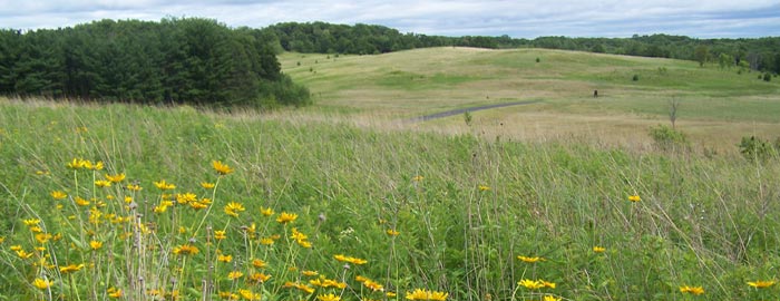
Chippewa Moraine, a terrain of knolls, mounds and kettle lakes, courtesy of
Wisconsin DNR. |
 |
| Map of Circle Trail, courtesy Wisconsin DNR. |
Wisconsin hike
visits landscape
shaped in ice age
Day hikers can wind their way through ancient lakes formed by melting glaciers on western Wisconsin’s Circle Trail.
The trail at the Chippewa Moraine State Recreation Area and Ice Age National Scientific Reserve forms a 4.5-mile loop. As the Recreation Area is part of the Ice Age National Scientific Reserve, Federal passes are honored.
To reach the trailhead, from U.S. Hwy. 53 in New Auburn, go east on County Road M. The rec area is in about 7 miles; watch for signs for the David R. Obey Ice Age Interpretive Center, which is on the left/north.
Melted glacers
The interpretive center is a good spot to start the hike. It offers displays explaining how the area was formed by glaciers as well as on cultural and natural history. Kids visiting the center can feed a bug to a fish, pet a turtle, dig for fossils, and even hold a snake.
From the interpretive center, head northwest on the Circle Trail. It’s a narrow path of packed dirt through forest with plenty of benches for resting along the way.
In short order, the path passes a pond. This part of the Circle Trail is a segment of the Ice Age National Scenic Trail. Payne Lake appears next on the left.
The many ponds and lakes the trail weaves past were created rather recently on geological timescales. About 14,000 years ago, glaciers covered this area to roughly a mile south of the interpretive center. As the glacier melted, sand, gravel and other rock were left amid massive chunks of ice; when new, temporary glaciers moved to cover the melt area, they pushed the debris together into hill-shaped piles and natural dams. The result was a 10-mile wide moraine and a series of irregularly shaped lakes and ponds amid plains and mounds.
Next, the trail heads between North Shattuck Lake (on the left/south) and North of North Shattuck Lake (on the right/north). These and the other waterbodies on the moraine consist of melted glacial water trapped amid the debris.
Bird migration
The Ice Age Trail separates as it heads west into the North of North Shattuck Lake State Natural Area. The state natural area and this section of the recreational area are popular among birds during the spring migration. Among those that can be spotted here are American redstarts, eastern wood-pewees, scarlet tanagers, woodpeckers (both hairy and red-headed), and yellow-throated vireos.
Horseshoe Lake next appears on the right/west. This puts you on the loop’s western side, where you’ll head between two ponds.
While spring and summer make for spectacular birdwatching across the moraine, early autumn also is a great time to visit as lily pads bloom on the ponds and bullfrogs come out and croak in full force. White-tailed deer fawns also are venturing out and can be more easily spotted grazing with their mothers.
Next, the trail crosses County Road M, placing you 1.4 miles from the trailhead. For those needing to walk a shorter distance, this marks a good place to turn back for a 2.8-mile round trip hike.
If continuing on, Jeanstow Lake next appears to the left/east. The trail then curves and begins the loop’s southern side.
Largest lake
After passing three ponds, the trail reaches the southeastern shores of South Shattuck Lake on the left/north. At 63 acres, South Shattuck is the largest of the lakes along the Circle Trail. It reaches a depth of 39 feet, and largemouth bass are common in it.
Once beyond South Shattuck Lake, the trail passes another pond on the left then crosses one. As the trail begins the western side of its loop, it rejoins the Ice Age Trail; at that junction, continue north.
The trail passes yet another pond on the right/east then crosses County Road M a second time. The junction is 3.92 miles from the trailhead. Upon doing so, the trail begins the loop’s north side.
The final legs consist of passing a pond on the right/northeast, then heading between two ponds. From there, the trail curves south with a new pond on right/west. After that, you’ll arrive back at the interpretive center and your parking lot.
Good news for dog owners: Fido and Queenie are allowed off leash on the trail but not in the yards at the interpretive center or in the picnic areas.
Learn more about Chippewa Valley day hiking trails in my
Day Hiking Trails of the Chippewa Valley guidebook.