 |
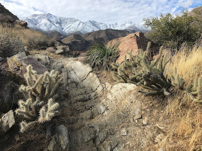
| Beautiful views of the Desert Divide’s snowcapped mountains await during winter. |
Day hikers can explore the ruins of a World War II tungsten mine in the foothills overlooking Palm Springs.
The 5.1-mile round trip Maynard Mine Trail sits on the historic Agua Caliente Band of Cahuilla Indians tribal grounds. It sports a 2001-foot elevation gain, so your quads are sure to get a good workout.
To reach the trailhead, from Calif. Hwy. 111 go south onto South Palm Canyon Drive. In two miles, you’ll reach the Indian Canyons tollgate; there is a fee per adult and a lower rate per child. Shortly after the toll, the road splits; turn right and heads to a gravel parking area. The trailhead is on the palm grove’s south side and marked with a sign.
Winter and spring mark the best times to hike the trail, and not just because of the cooler temperatures. Great views of snowcapped mountains, especially on the Desert Divide, highlight any December through February hike. Wildflowers usually are in full bloom during early April.
The narrow trail sometimes is rocky with plenty of switchbacks.
Catclaw acacia
Watch for catclaw acacia, whose thorned branches easily can cut your skin. It’s sometimes called the wait-for-me bush as passersby who rub against the shrubs often need to stop and remove thorns from their clothing.
In arroyos, catclaw acacia can grow quite large – up to 49 feet high with a trunk nearly a foot around – but on these dry foothills, they tend to be quite stout.
Thanks to the catclaw, you might spot gambrel quail, which feed on the bush’s seeds, or even mule deer, who enjoy its fruit. Rabbits and lizards also abound on the trail, even if there’s no catclaw nearby.
During World War II, Palm Springs resident Jim Maynard – who founded the area’s first search-and-rescue group that evolved into the Palm Springs Mounted Police Search and Rescue team – mined tungsten near the trail’s end. Renowned for its hardness and high melting point, tungsten was in demand for the U.S. war effort.
After digging rock with small quantities of the rare tungsten in it, Maynard would haul it down the trail in a wheelbarrow. A plaque honoring Maynard sits next to a collapsed mine shaft along the trail.
Mine entrance
A sign marks where the trail ends, but you can continue beyond that and descend to the entrance of one of Maynard’s other tungsten mines. You also can go into the fairly shallow mine, but always do so cautiously.
Small pieces of abandoned equipment sit near the mine entrance. Among them is an old gasoline powered engine.
There’s no shortage of great views on the return hike. San Jacinto Peak looms above, canyons boasting palm trees and in spring running water sit below the ridgeline, and Palm Springs spreads out in the flat valley beyond.
The trail is fully exposed to the sun, so be sure to don sunscreen, sunglasses and sunhat and to bring plenty of water. Avoid this trail during summer. Dogs are not allowed.
 |
| Maynard Mine Trail topo map. Click for larger version. |
Learn more about national park day hiking trails in my Best Sights to See at America’s National Parks series.
