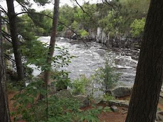
Day hikers can spot a number neat geological features on the Lost Pothole Trail at Minnesota Interstate State Park.
Among the features are glacial potholes, a river gorge of billion-year-old rock, and the Squeeze.
To reach the park, take U.S. Hwy. 8 into downtown Taylors Falls, Minn. At the Bench Street intersection, turn southeast toward the river into the park. The road enters the parking lot. Pick up the trailhead on the lot’s west side.
The trail is more a series of paths through ancient billion-year-old volcanic basalt beneath red pines (below).
The highly resitant basalt formed when this part of North America was a rift valley as the continent temporarily began to split (below).
The volcanic rock was exposed about 10,000 years ago as flood waters from melting glaciers rushed through the St. Croix River Valley (below).
Today, the St. Croix River is much lower than during the Ice Age and flows between cliffs of volcanic rock (below).
Potholes were formed about 10,000 years ago when swirling glacial meltwater sweeping down the river drilled holes into the ancient basalt bedrock (below).
Among the most famous of the park’s potholes is the Lily Pond Pothole (below).
Also on the trail is the Squeeze, an exceedingly tight, L-shaped break between two ultra large chunks of basalt (below).
Here's a full description of the trail and others nearby at the state park.
Learn about trail guidebooks available in the Hittin’ the Trail series.


