 |
| Some 500 years ago, Cahuilla Indians constructed fish traps on what used to be the shores of Ancient Lake Cahuilla. |
 |
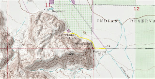
| Fish Traps Trail topo map. Click map for larger version. |
Day hikers can explore an ancient fishing site on an extinct lake south of Indio, Calif.
The 1.4-miles round trip Fish Traps Trail rambles past petroglyphs, pottery shards, bedrock mortars, and other artifacts at the Fish Traps Archeological Site. It sits in the Santa Rosa and San Jacinto Mountains National Monument.
To reach the site, from Interstate 10
in Indio take Jackson Street south. After passing 64th Avenue, the road curves east and becomes Avenue
66. The trailhead is at the point of the curve where Jackson Street becomes Avenue 66. Park on the right/south side of the road.
Walk west on the rocks alongside the orchard fence. Upon reaching the fence's end and the foothill's base, go right/north. The terrain will be full of scree, so be careful with your steps.
Ancient Lake Cahuilla
About 500 years ago, this was a shoreline for Ancient Lake Cahuilla. The freshwater lake covered the southern half the Coachella Valley and all of what is now the Salton Sea. Any place in the valley lower than 40 feet above sea level was under water.
The first set of petroglyphs appears in about 200 feet. Etched into the tufa rock - which is calcium carbonate formed by precipitation from warm water - is a spiral shape, a lizard, etch marks, and other forms that look like either birds or palm trees depending on your perspective.
These markings were made by the ancestors of today's Cahuilla Indians. Lake Cahuilla sat at the southern end of their range, which covered about half of Riverside County and stretched across the Mojave Desert north into San Bernardino County.
Continuing along the foothill's base, in about 350 feet is a bedrock mortar and pestle in a small boulder. The mortar is the bowl while the pestle is the rock that fits into a hand next to it. This was used to crush and grind ingredients into powder.
Fish trap technology
About 50 feet beyond that is a fish trap. Rocks were piled in a circle so that when fish swam into them they could be more easily captured.
In other cases, stones on the lake bottom were removed to form pits. This can be spotted in about 1000 feet and then again in 1200 feet. Archeologists believe this site is one of the few places in the world where stone pits were built to trap fish.
With Lake Cahuilla 20 times larger than the present day Salton Sea, there was plenty of freshwater fish to go around. The stone fish traps were so effective that the lake supported at least 20,000 people and perhaps up to 100,000.
A small rocky trail heads up the scree to what once was an ancient campsite. As you ascend, watch for the change in the rock color forming a horizontal line across the scree; this marks the ancient lake's water level.
Pottery sherds, broken animal bones likely used as tools, and the shells of creatures that once lived in the lake also can be found along the way and in the scree. At about 0.7 miles from the trailhead, the artifacts no long appear, so that makes a good turnaround point.
Evaporated lake
When the Colorado River's changed course, Lake Cahuilla was left isolated and as with the Salton Sea today, evaporated. The lake dried up within 70-80 years, and the Fish Traps site was abandoned.
As the tufa is fragile, be careful where you step, and do not touch any of the petroglyphs. The tufa easily can break off, damaging the site or cutting you.
Do not take anything from the site or move about objects. Scratching your own initials into the tufa is considered vandalism so please refrain from doing so.
As the entire site is exposed to the sun, always don sunscreen, sunglasses and sunhat. Good hiking boots are recommended, as you'll cross or walk around scree.
