Here are some great wildflower trails to hike in southern Minnesota.
Amador Prairie Loops
Wild River State Park
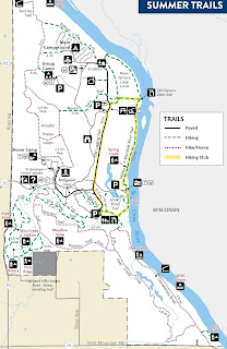
Minnesota’s Northwoods is far more diverse than fragrant pine trees and picturesque lakes. At Wild River State Park, hikers can enjoy some of that variety by taking the shorter of the Amador Prairie Loops through a restored prairie with plenty of wildflowers. In mid-September on the 2.1-mile trail, asters and goldenrods usually peak, a pretty sight against the tall grasses’ reds. From Amelund, take Minn. Hwy. 12 (aka Park Road) east into the park. Past the service road, turn at the first left to the trail center. Trail map:
Lilydale Park Trail
Lilydale Regional Park
Hikers can see wildflowers of a forest floodplain right in the middle of the state’s largest metro area at Lilydale Regional Park. The 1.6-mile round trip Lilydale Park Trail runs through the 380-acre public area in Saint Paul. Wild ginger, Canadian honewort , pointed-leaf tick-trefoil, and spotted touch-me-not flower are just some of the flowers that can be seen. American lotus dot Pickerel Lake from July to September. From downtown St. Paul take Interstate 35E south. Upon crossing the Mississippi River, exit onto Minn. Hwy. 13/Sibley Memorial Highway. Go left/northeast. Turn right/south onto County Road 45/Lilydale Road. After going under the railroad overpass, look for an entry road on the left/northwest that heads to a parking lot. At the lot’s north side, take the trail northeast. Trail map:
Lower and Upper Cliffline Trails
Blue Mounds State Park
Hikers can experience a bit of the American Southwest at Minnesota’s Blue Mounds State Park. The 4.1-mile Mound Trail loops past prickly pear cactus and across rock formations that look like they would be more at home in Arizona than in Bullwinkle the Moose’s home state. From Luverne take U.S. Hwy. 75 north. Turn right/east onto County Road 20. Park in the lot where the road ends. The trail begins at the lot’s northeast corner. Trail map:
Nature Trail
Eloise Butler Wildflower Garden and Bird Sanctuary
Day hikers can explore the United States’ oldest public wildflower garden near Minneapolis. A 0.72-mile round trip trail runs through a woodland, wetland and prairie at Eloise Butler Wildflower Garden and Bird Sanctuary in Theodore Wirth Park. Among the highlights in April and May are large-flowered trillium, bloodroot, wild ginger, bluebell and trout lily in the woodlands. From the junction of Interstate 35 and Minn. Hwy. 100, take the latter north. Exit onto Glenwood Avenue/County Road 40 and go east. Next, turn right/south onto Theodore Wirth Parkway then left/east onto Butler Garden. A parking lot is on the left across from the entrance. Trail map:
River Terrace Prairie Trail
River Terrace Prairie State Natural Area
Day hikers can explore wildflowers of a gravel prairie at River Terrace Prairie State Natural Area. The 1.54-mile round trip River Terrace Prairie Trail runs along the edges of the state natural area and includes a segment of the Cannon Valley Trail. The natural area is known for its spectacular displays of pasqueflower in April. From Cannon Falls, take Minn. Hwy. 19 east. Turn left/north onto Sunset Trail. After the road and Cannon River make a 90 degree turn east, watch for a dirt jeep trail heading right. Park on the road shoulder near it. Trail map:
South and North Overlooks Trail
Williams Nature Center
Native wildflowers can be enjoyed at Williams Nature Center outside of Mankato. The 1.8-mile round trip South and North Overlooks Trail heads through the 65-acre county park. Three stacked loops wind across the park’s woodlands. Among the flowers you’re likely to see are showy orchid, purple coneflower, and the cup plant. From Mankato take U.S. Hwy. 169 west. Turn right/northwest onto Minn. Hwy. 68. The park entry is on the right/north and ends at a parking lot. Trail map:
Wildflower Trail
Carley State Park
Hikers can revel in the thousands of bluebells and false rue anemone that cover an oxbow in the North Branch of the Whitewater River every May at Carley State Park. The 2.42-miles looping Wildflower Trail follows the river branch through a white pine-lined sunken bowl in the middle of farmland. It’s best done in late April through early May and will be busy when the park holds its annual Bluebell Festival each May. From Plainview, take County Road 4 south. The park entrance road is on the right/west. Once in the park, take the first left/west; this is a loop offering access to the park’s group camps. The parking lot is on the south side of the loop. From the lot, follow the road north then go left/west onto the loop. Trail map:


