 |
| Wildwood Trail west of Woodville, Wis. |
 |
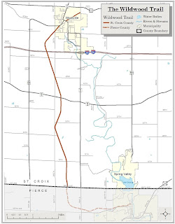
| Wildwood Trail map |
The seven-mile hiking, biking and snowmobiling trail runs between the communities of Woodville and Spring Valley in eastern St. Croix County. Among the most accessible and pleasurable parts of the trail is a 2.3-miles round-trip from western Woodville that heads past farm fields.
To reach the trailhead, from downtown Woodville take County Road BB west. Park on the street near the post office then walk along the road about 600 feet west. The trailhead is on County BB’s left/south side just past the Solum Drive intersection.
A former railroad right-of-way, St. Paul, Minneapolis and Omaha Railway Company trains used the route until the mid-20th century. In 1970, St. Croix County purchased most of the railbed.
The trail segment at Woodville heads into the dairy country for which this part of Wisconsin is so well known. While the path is lined with tall trees and a thick understory, you’ll still catch good views of hay and corn fields on either side of the trail.
In about 0.1 miles, the trail crosses 250th Street. Shortly after that, a bridge heads over an intermittent stream that flows off the higher elevations to the northwest.
At 0.75 miles into the hike, the trail gradually curves to the east. Where it reaches the middle of that curve and heads directly southeast marks a good spot to turn back. Any farther south brings you close to Interstate 94 and its river of vehicular noise.
Another option for hiking the trail is starting just north of the 250th Avenue and 42nd Street intersection, where there’s a gravel parking lot. Going northwest heads past another intermittent stream while the southeast route runs through a thick woods.
As a former rail grade, the trail is wide and often open, so be sure to don sunscreen or a brimmed hat. Motorized vehicle traffic – except snowmobiles in winter – are prohibited on the trail.
Learn more about nearby day hiking trails in my Day Hiking Trails of St. Croix County guidebook.
