The park preserves more than 1,200 square miles of the Chihuahuan Desert along the international border with Mexico, marked by the Rio Grande. The easy 1.4-mile long trail takes you right up to the river border through Boquillas Canyon, one of park’s three largest canyons.
To reach the trail, from U.S. Hwy. 385, take Park Route 12 to Rio Grande Village then turn onto Boquillas Canyon Road. The parking area and trailhead is at the road’s end.
The Boquillas Canyon Trail heads over a low limestone hill, descends to the Rio Grande’s banks, then skirts the river shoreline:

Map of the trail:

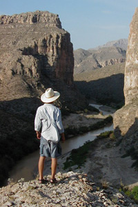
Before arriving at the trail, considering pulling off into the overlook for a view of the canyon (photo courtesy of Big Bend NPS):
Sign at trailhead (showing there's plenty of bird life in the canyon):

Spring flowers bloom in this 3D photo of the trail leading into the canyon (photo courtesy USGS):

Gravel bar along the Rio Grande in a 3D photo of the trail inside the canyon (photo courtesy USGS):

Boca, or a weathered cave, in the limestone cliff, in a 3D photo of the trail inside the canyon (photo courtesy USGS):

Here's a full description of the trail.
Learn about other great national park day hiking trails in my Best Sights to See at America’s National Parks guidebook.
